
The Gearagh facts for kids
Quick facts for kids The Gearagh |
|
|---|---|

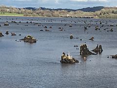
Ancient oak stumps near the first bridge at the Sleaveen side of the Port road
|
|
| Location | County Cork, Ireland |
| Designated: | 30 May 1990 |
| Reference #: | 472 |

The Gearagh (pronounced "Gyar-ah") is a very special nature reserve in County Cork, Ireland. Its Irish name, An Gaorthadh, means "the wooded river-valley" or "the river-bed." It's a forest that was flooded a long time ago, about two kilometers southwest of Macroom.
This amazing place is where the River Lee flows down from the mountains and spreads out into a wide, flat area. The Gearagh stretches for about five kilometers.
Before it was flooded, The Gearagh was full of very old oak trees. It was the last large oak forest of its kind in Western Europe!
In 1954, the area was flooded on purpose. This happened to build two power stations, Carrigadrohid and Inniscarra. These stations use water to make electricity for the city of Cork. Because of this project, hundreds of old trees were cut down, and many people had to move their homes. Today, you can still see the stumps of these ancient trees sticking out of the water. It makes the area look quite mysterious!
Now, The Gearagh is a wide but shallow lake with many small islands. These islands are separated by winding river streams. It's still a place of incredible natural beauty. It has a rich variety of plants, birds, and fish. You can find creatures like freshwater pearl mussels, Atlantic salmon, whooper swans, kingfishers, and otters here.
The Gearagh is so important that it's protected by international agreements. It's a wetland of international importance under the Ramsar Convention. It's also an EU Special Area of Conservation, covering 558 hectares. Part of it is even a nature reserve under the Irish Wildlife Act, and the reservoir is a safe place for wild birds.
The Gearagh's Past
The Gearagh has been a wooded area for a very long time. Experts believe trees have grown here since the end of the last Ice Age, around 8,000 BC. It's located right where the River Lee leaves the hills and spreads out onto flat, fertile ground.
Until the 1950s, this area was a huge forest. It was filled with many oak and ash trees. But in 1954, things changed when the Lee Valley hydro-electric power plant was built. This project meant many trees had to be cut down, and the area was flooded. Many of these trees were hundreds of years old. People who lived there also had to move. About sixty percent of the original oak forest was lost.
Local stories say that mischievous spirits called the Meascan Maraiocht used to live in the area. They would try to confuse visitors and lead them astray!
Amazing Wildlife and Conservation Efforts

The Gearagh is incredibly important because of its rare and diverse wildlife. It's the only large natural forest of its kind left in Western Europe that grows on river floodplains.
You can find many rare plants here, including marsh marigold, meadowsweet, and nightshade. There are also 62 different kinds of moss and liverwort. While oak and ash trees used to be everywhere, now you'll see more willow and alder trees on the higher islands.
The Gearagh is a home for many different birds and wildfowl. It attracts birds that travel here in both summer and winter. Some examples include mallards, wigeon, Greylag geese, herons, and coots. It's also home to Atlantic salmon and the very rare freshwater pearl mussel. Because of its importance, the area is protected by the international Ramsar Convention.

Many people have worked hard to protect The Gearagh. One of them is environmental biologist Kevin Corcoran. He said that before the dam was built, this was "the last pure stand of ancient riverine forest that had survived intact since the last ice age." He also mentioned that it was one of only four such systems on the entire planet!
Corcoran described The Gearagh as "immense" in importance. He explained how it was "hard to imagine what the area looked like before being flooded – a vast inland delta of inter-connecting, many branched streams that encircled a maze of small and inaccessible islands, covered in oak forest." He added that its swampy ground and tricky streams protected it from people.
Filmmaker Declan O’Mahony believes that if the water level was lowered permanently, The Gearagh could grow back. He thinks it has the potential to become a world heritage site, like Newgrange or the Giant’s Causeway.
In 1987, The Gearagh was officially declared a nature reserve. It is protected by the Wildlife Act, but it is owned by the ESB.
Gallery
-
Submerged oak tree stumps, high water
-
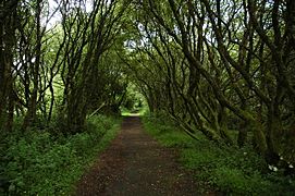
The main pathway, which is part of the old Port road, crosses The Gearagh with a series of bridges.
-
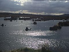
Inlets and islands within The Gearagh
-
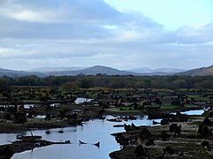
The Gearagh at a low water level


