Doda district facts for kids
Quick facts for kids
Doda district
|
|
|---|---|
|
District of Jammu and Kashmir administered by India
|
|

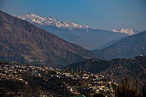
View of Doda city
|
|

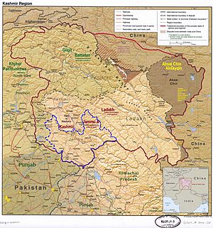
Doda district is in the eastern part of the Jammu division (shown with neon blue boundary) of Indian-administered Jammu and Kashmir (shaded in tan in the disputed Kashmir region
|
|
| Administering country | India |
| Union Territory | Jammu and Kashmir |
| Division | Jammu |
| Region | Chenab Valley |
| Headquarters | Doda |
| Area | |
| • Total | 2,625 km2 (1,014 sq mi) |
| • Urban | 19.75 km2 (7.63 sq mi) |
| • Rural | 2,605.25 km2 (1,005.89 sq mi) |
| Population
(2011)
|
|
| • Total | 409,936 |
| • Density | 156.166/km2 (404.47/sq mi) |
| • Urban | 32,689 |
| • Rural | 377,247 |
| Demographics | |
| • Literacy | 64.68% |
| • Sex ratio | 919 |
| Time zone | UTC+05:30 (IST) |
| Vehicle registration | JK-06 |
| Major highways | NH 244 |
Doda district is an administrative area located in the Jammu division of Jammu and Kashmir, which is a territory administered by India. It is part of the Kashmir region, which has been a subject of dispute.
Contents
Administration and Geography
Doda district is divided into 18 smaller areas called tehsils. These include Thathri, Bhaderwah, Doda, Mohalla, Bhagwa, Assar, Bhalla, Gundna, Marmat, Kahara, Gandoh (Bhalessa), Bhella, Bharat Bagla, Chiralla, Chilly Pingal, Phagsoo and Kastigarh. The district also has 406 villages.
Climate of Doda District
The weather in Doda district changes a lot because of its different altitudes. Generally, it has a mild to warm climate. The area is mostly dry, with little rainfall. Temperatures vary from place to place. Lower areas like Ramban and Doda tehsils are warmer. Higher regions, such as Dessa Valley and Warwan, are covered in snow for about five to six months each year.
Summers are usually dry. In winter, all regions experience snowfall in higher areas and rain in lower ones. The monsoon season, with heavy rainfall, occurs from July to September. The district gets about 926 mm of rain and 135 mm of snow annually.
History of Doda District
The population of Doda district is quite mixed. In the past, many Sarazi people lived here before others from Kashmir and nearby areas settled. Kashmiri people began moving here in the 17th and 18th centuries. Some historians say people moved to Doda, Ramban, and Kishtwar to escape difficult conditions elsewhere.
Doda district includes areas that were once part of the old kingdoms of Kishtwar and Bhadarwah. These areas later became part of a larger district called 'Udhampur' in the princely state of Jammu and Kashmir.
How Doda Got Its Name
According to local records, the district's main town, Doda, was named after a utensil maker from Multan. An old ruler of Kishtwar convinced him to settle in the area and start a factory. Over time, the name "Deeda" changed to "Doda."
Early Rulers and the Doda Fort
The early history of Doda is not well-known, as there are few written records about the rulers of Kishtwar. Historical reports suggest that various groups ruled the area over time. These included Ranas, Rajas, and independent chiefs like the Jaral Ramas and Katoch Rajas. In 1822 AD, Maharaja Gulab Singh took control of Doda, and it became the winter capital of the Kishtwar state.
The Fort of Doda was very important in the district's history. It was one of about seventy forts in the Jammu province. The fort was used as an office and to store weapons and food. It also protected against attacks from the Bhaderwah Rajas. The fort was built with unbaked bricks, with thick, tall walls and round towers at the corners. The fort was taken down in 1952, and today, a school stands on its site.
Traveler's Tales
In 1829, an English traveler named G.T. Vigne visited Doda. He wrote about his journey through a deep, rocky valley that met the Chenab River. He described crossing the river on a risky bridge in the Himalayas. Vigne mentioned a strong rope bridge in Doda, where a wooden platform moved back and forth on ropes. He also saw another type of bridge made of small ropes and bark, which people walked across while holding onto hanging ropes for support.
Changes Over Time
The area of Bhaderwah has a long history, going back to the 10th century. In 1846, Doda and Kishtwar became part of the new state of Jammu and Kashmir after an agreement called the Amritsar pact. Bhaderwah was once a small kingdom with 15 administrative units. It was ruled by different kings until it was taken by the Kishtwar Raja. Later, it became part of Chamba and then was transferred to Jammu in 1846.
In 1948, the old Udhampur district was split into the current Udhampur district and the 'Doda' district. The Doda district then included Ramban, Bhadarwah, Thathri, and Kishtwar tehsils.
Later, in 2006, Ramban became its own district, and the hilly eastern part of Doda was separated to form the Kishtwar district. The remaining areas now make up the Doda tehsil and the original Bhadarwah, which is now divided into three tehsils.
Recent Events
In the 1990s, the region faced security challenges, and some groups caused problems. To help with safety, the government formed Village Defense Committees (VDCs) in many villages. However, there were also reports of some VDC members causing issues. In June 2023, Doda district was shaken by an earthquake of 5.4 magnitude.
People of Doda District (Demographics)
| Historical population | ||
|---|---|---|
| Year | Pop. | ±% |
| 1901 | 102,011 | — |
| 1911 | 112,009 | +9.8% |
| 1921 | 117,759 | +5.1% |
| 1931 | 127,477 | +8.3% |
| 1941 | 140,446 | +10.2% |
| 1951 | 147,489 | +5.0% |
| 1961 | 154,532 | +4.8% |
| 1971 | 170,787 | +10.5% |
| 1981 | 224,197 | +31.3% |
| 1991 | 290,727 | +29.7% |
| 2001 | 372,613 | +28.2% |
| 2011 | 476,835 | +28.0% |
| † 1951 and 1991 populations are estimated Source: Census of India |
||
| Religion in Doda district (2011) | ||||
|---|---|---|---|---|
| Religion | Percent | |||
| Islam | 53.82% | |||
| Hinduism | 45.77% | |||
| Other or not stated | 0.41% | |||
According to the 2011 census, Doda district had a population of 409,936 people. This number is similar to the population of the country of Malta. Doda ranks 556th in population among the 640 districts in India. The district has about 79 people living per square kilometer. Between 2001 and 2011, the population grew by about 27.89%.
Doda has a sex ratio of 922 females for every 1000 males. The literacy rate (the percentage of people who can read and write) is about 65.97%.
Religions in Doda
The district has a majority of Muslims, making up 53.82% of the population. Hindus make up 45.77%, and a small number of Christians, Sikhs, Buddhists, and Jains live there too. The people of Doda live together peacefully, even though they follow different religions. Most Muslims in the region are ethnic Kashmiris and share similar culture and language with people from Kashmir.
| Doda district: religion, gender ratio, and % urban of population, according to the 2011 Census. | |||||||||
|---|---|---|---|---|---|---|---|---|---|
| Hindu | Muslim | Christian | Sikh | Buddhist | Jain | Other | Not stated | Total | |
| Total | 187,621 | 220,614 | 472 | 422 | 21 | 22 | 42 | 722 | 409,936 |
| 45.77% | 53.82% | 0.12% | 0.10% | 0.01% | 0.01% | 0.01% | 0.18% | 100.00% | |
| Male | 98,252 | 114,372 | 324 | 286 | 9 | 11 | 24 | 363 | 213,641 |
| Female | 89,369 | 106,242 | 148 | 136 | 12 | 11 | 18 | 359 | 196,295 |
| Gender ratio (% female) | 47.6% | 48.2% | 31.4% | 32.2% | 57.1% | 50.0% | 42.9% | 49.7% | 47.9% |
| Sex ratio (no. of females per 1,000 males) |
910 | 929 | – | – | – | – | – | 989 | 919 |
| Urban | 9,786 | 22,668 | 40 | 153 | 0 | 14 | 0 | 28 | 32,689 |
| Rural | 177,835 | 197,946 | 432 | 269 | 21 | 8 | 42 | 694 | 377,247 |
| % Urban | 5.2% | 10.3% | 8.5% | 36.3% | 0.0% | 63.6% | 0.0% | 3.9% | 8.0% |
| Sex Ratio in Doda District in 2011 Census. (no. females per 1,000 males) |
||||
|---|---|---|---|---|
| Religion (and population) | Sex Ratio | |||
| Muslim (pop 220,614) | 929 | |||
| Hindu (pop 187,621) | 910 | |||
| Other (pop 1,701) | 673 | |||
| Total (pop 409,936) | 919 | |||
Languages Spoken
Many people in Doda district speak Kashmiri as their main language, making up about 40% of the population. Other common languages are Pahadi languages, especially Bhadarwahi and Siraji. People also speak Gojri and Dogri. Most people in the area know several of these languages, which helps different communities communicate easily.
Politics
Doda district has three areas for elections: Bhaderwah, Doda, and Doda West.
See also
 In Spanish: Distrito de Doda para niños
 | Janet Taylor Pickett |
 | Synthia Saint James |
 | Howardena Pindell |
 | Faith Ringgold |


