
Double Peak (Washington) facts for kids
Quick facts for kids Double Peak |
|
|---|---|

Double Peak seen from Highway 123
|
|
| Highest point | |
| Elevation | 6,199 ft (1,889 m) |
| Prominence | 759 ft (231 m) |
| Geography | |

Double Peak
Location in Washington (state)

Double Peak
Location in the United States
|
|
| Location | Mount Rainier National Park, Pierce County, Washington, U.S. |
| Parent range | Cascades |
| Topo map | USGS Chinook Pass |
| Climbing | |
| Easiest route | Scrambling |
Double Peak is a cool mountain that gets its name because it has two main tops, or "summits." It stands tall at about 6,199 feet (1,889 meters) high! You can find it inside Mount Rainier National Park in Washington state, in a place called Pierce County.
This peak is part of the amazing Cascade Range, a long chain of mountains. Double Peak is located near other interesting spots like Shriner Peak to its southeast, Governors Ridge to its north, and the Cowlitz Chimneys to its west.
Weather Around Double Peak
Double Peak is in a part of North America that has a "marine west coast" climate. This means it gets a lot of weather from the Pacific Ocean.

Most of the weather systems, like big clouds and storms, start over the Pacific Ocean. They then travel northeast towards the Cascade Mountains. When these weather systems hit the tall mountains, they are forced to go higher. This makes them drop their moisture as rain or snow.
Because of this, the western side of the Cascade Mountains gets a lot of rain and snow. This is especially true in winter, when there's often heavy snowfall. In winter, the weather is usually cloudy. But in summer, the weather is often sunny with clear skies. This is because of high-pressure systems over the Pacific Ocean. The water that melts from Double Peak flows into streams that eventually join the Cowlitz River.
Images for kids
-
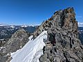
Peak of Double Peak
-
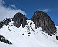
Double Peak (left) and Double Peak-Northeast Summit (right) as viewed from the southeast
-
North aspect, from Tamanos Mountain
-
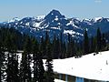
Double Peak seen from Tipsoo Lake
-
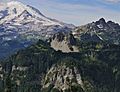
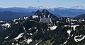
Mt. Rainier, Double Peak (centered), and the Cowlitz Chimneys (right) seen from Shriner Peak.


