
Shriner Peak facts for kids
Quick facts for kids Shriner Peak |
|
|---|---|

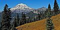
Shriner Peak seen from Highway 410
|
|
| Highest point | |
| Elevation | 5,834 ft (1,778 m) |
| Prominence | 754 ft (230 m) |
| Isolation | 2.44 mi (3.93 km) |
| Parent peak | Point 6057 |
| Geography | |

Shriner Peak
Location in Washington (state)

Shriner Peak
Location in the United States
|
|
| Location | Mount Rainier National Park, Pierce County, Washington, U.S. |
| Parent range | Cascades |
| Topo map | USGS Chinook Pass |
| Climbing | |
| Easiest route | Hiking trail |
Shriner Peak is a mountain in Mount Rainier National Park in Washington state. It stands 5,834 feet (1,778 meters) tall. This peak is part of the Cascade Range, a large mountain chain.
Shriner Peak is located in Pierce County. It sits south of Cayuse Pass and southeast of Double Peak. A four-mile trail leads from Highway 123 right to the top. At the summit, you'll find the Shriner Peak Fire Lookout. Rain and snow that fall on Shriner Peak flow into streams that eventually join the Cowlitz River.
Weather at Shriner Peak
Shriner Peak is in a "marine west coast" climate zone. This means it gets a lot of moisture from the nearby Pacific Ocean. Most weather systems start over the Pacific. They then travel northeast towards the Cascade Mountains.
When these weather systems hit the tall Cascade Mountains, they are forced to rise. As the air goes higher, it cools down. This cooling causes the moisture in the air to turn into rain or snow. This process is called "orographic lift." Because of this, the western side of the Cascades gets a lot of rain and snow.
Winters at Shriner Peak are usually cloudy and snowy. However, during the summer, high-pressure systems over the Pacific Ocean often bring clear skies. The snow here tends to be wet and heavy. This can sometimes lead to a high risk of avalanches.
Hiking to the Top
The trail to Shriner Peak is a popular hike. It starts from Highway 123 and is about four miles long. The path takes you through beautiful forests and offers amazing views.
When you reach the summit, you'll find the Shriner Peak Fire Lookout. This lookout was built to help spot forest fires. From the top, you can see incredible views of Mount Rainier and the surrounding area. It's a great spot for taking photos and enjoying nature.
Images for kids
-
Mt. Rainier, Double Peak, and Cowlitz Chimneys from Shriner

More Information
- National Park Service web site: Mount Rainier National Park
- Weather: Shriner Peak
