
Drumanagh facts for kids

Drumanagh (in Irish, Droim Meánach) is a headland or piece of land sticking out into the sea. It's located near the village of Loughshinny in north-east Dublin, Ireland. This special place has an old Martello tower from the early 1800s. It also has a very large Iron Age fort, which is about 200,000 square meters in size. What's really interesting is that people have found Roman objects there!
Some experts who study old things (called archaeologists) think Drumanagh might have been a base for Roman soldiers. Others believe it was a Roman trading post, a place where people regularly met to trade, or even an Irish settlement that traded with Roman Britain.
In 2017, Fingal County Council bought the site. They want to protect it from damage and make it part of coastal walking paths. People hope this will lead to proper archaeological digs to answer the many questions about Drumanagh.
What Drumanagh Looks Like

Drumanagh is a small peninsula, which means it's almost surrounded by water. It's about 40 acres in size. To protect the land, there are three long, parallel earth banks with ditches in front of them. These run for about 350 meters across the neck of the headland. With steep cliffs on the other sides, this made it a very strong place to defend.
These earthworks might be from the Bronze Age or the Iron Age. They are similar to other ancient forts found in Ireland. The headland is roughly rectangular, getting narrower towards the sea. The Martello Tower is located near the very tip of the headland.
The Irish Sea surrounds Drumanagh on three sides. The sea has caused a lot of erosion, which means the land has worn away over time. This might have made the headland smaller and could have destroyed signs of old Roman buildings.
Drumanagh is a "Recorded Monument," which means it's protected by law. Its importance was first known in the 1950s when Roman pottery pieces (called Samian ware) were found. Even though it's important, there haven't been many official archaeological digs. However, many objects have been found by people using metal detectors without permission. Some Roman coins and ornaments found this way are now kept in the National Museum of Ireland.
More than 40 metal blocks (called ingots) of copper and brass have been discovered here. There were also copper mines nearby in Loughshinny. This suggests that Drumanagh might have been a place where people worked with metals during the Iron Age.
Drumanagh's History

Some historians, like Barry Raftery and Gabriel Cooney, think that the Roman general Gnaeus Julius Agricola might have used Drumanagh. They suggest he could have used it as a base for an invasion of Ireland in 82 AD. The Roman historian Tacitus wrote that Agricola met an Irish prince who was in exile. Agricola thought about using him as an excuse to conquer Ireland.
Tacitus also wrote that Agricola "crossed in the first ship" and defeated people the Romans had never known before. Tacitus didn't say exactly which body of water Agricola crossed. Many scholars believe it was in Britain, but the rest of that chapter is all about Ireland.
Agricola made the coast facing Ireland stronger. Tacitus remembered that Agricola's father-in-law often said Ireland could be conquered with just one Roman legion (a large army unit) and some helper soldiers (called auxiliaries). This conquest never happened. But some historians believe that Agricola's crossing was indeed a military trip to Ireland.
Vittorio De Martino believes that Roman Britain and Ireland were always in contact. Professor Michael Herity from UCD thinks that the many Roman objects found at Drumanagh suggest it was a busy Irish trading center (an emporium). This center traded a lot with the Roman world.
Richard Warner suggests that Drumanagh might have been a landing spot for Irish and British adventurers. These adventurers, with Roman help, might have created new kingdoms for exiled Irish noblemen. He connects this idea to the legend of Túathal Techtmar. This legend says Túathal was exiled to Britain in the 1st or 2nd century. He then returned with an army to become king.
Roman brooches and decorative metal items have been found in burials on Lambay Island, which is very close to Drumanagh. These items are similar to those found in Roman Britain from the late first century. Other Roman objects, like jewelry and coins, have also been found in Ireland at places like Tara and Clogher. These discoveries support the idea that Romans might have had some presence or influence in Ireland.
Images for kids
-
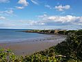
A view of Drumanagh from Loughshinny.

