Dulas Bay facts for kids
Dulas Bay (called Bae Dulas in Welsh) is a lovely small bay on the northeast coast of Anglesey, an island in north Wales. It sits between the communities of Llaneilian and Moelfre. This beautiful bay has three main beaches.
What is Dulas Bay Like?
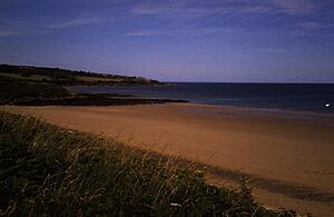
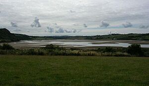
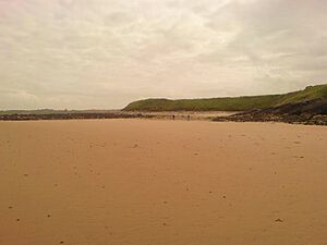
The beach on the northwest side is called Traeth Dulas, which means Dulas Beach. It's a mix of sand, shingle, and mud, and it's also where a river meets the sea (this is called an estuary). South of Traeth Dulas, you'll find a tiny beach named Traeth Bach (Small Beach). Next to that is the sandy Traeth Yr Ora, which means Beach of The Fortified Landing Place.
The Afon Goch (Red River) flows into the sea through Traeth Dulas. When the tide is high, Traeth Bach and Traeth Yr Ora are separated by a rocky area called Craig y Sais (The Saxon Rock). But when the tide is low, you can walk across the sand between all three beaches. You can even walk to the beaches of Lligwy Bay further south! Traeth Dulas is most affected by the tide. The parts of the estuary furthest inland become salt marshes, which are muddy areas covered by salty water at high tide.
About a mile and a half offshore, there's a small island called Ynys Dulas. It's about 620 meters long and 205 meters wide. This island is famous for the seals that live there, which is why locals sometimes call it Seal Island! It's too small for people to live on. However, in 1821, a round building with a cone-shaped roof was built there by James Hughes. This building was used to store food and give shelter to sailors who were shipwrecked.
There are two even smaller islands nearby. One is Garreg Allan (The Outer Stone), which you can't see from the shore because it's behind Ynys Dulas. The other is Ynys y Carcharorion (Prisoners' Island), which is closer to Traeth Dulas. Sometimes, you might see large oil tankers far out in the Irish Sea. They wait there for the right tide to enter the River Mersey and unload their cargo.
Exploring Dulas Bay's Past
The depth of the sea in Dulas Bay is quite interesting. For about a mile out from the shore, the water isn't deeper than 20 meters. The steepest drop in the seabed is found off Traeth yr Ora. On the other hand, there's a raised shelf of seabed about 1.5 kilometers long that stretches out past Garreg Allan, and none of it is deeper than 5 meters. After this shelf, the water suddenly gets much deeper (over 20 meters). This suggests that Ynys Dulas might have once been part of a headland (a piece of land sticking out into the sea) that later sank, or perhaps a tombolo (a sandbar connecting an island to the mainland).
On the north side of Traeth Dulas, you'll find a unique house called Porto Bello. It's built in a style that reminds people of the Mediterranean. On top of the cliffs just south of Traeth yr Ora, looking out over the Irish Sea, there's a concrete observation post left over from World War II.
A little north of the bay is the village of Llysdulas. This is where the old manor house, Llys Dulas (meaning Dulas Manor), used to be. The families who owned the bay lived here. Long ago, this land belonged to a tribe called Llwyd. Later, it was owned by the Neave and Hughes families. Sadly, when Lord Boston owned it, the large house was no longer used and doesn't exist today. You can still find some ruins of the old chapel.
Local stories say that Traeth yr Ora and Porto Bello were named after a group of men who were shipwrecked in the area around 1750. People thought they were from Spain or Portugal. However, the way the names are spelled makes some people think they might have actually been Italian. Some families in the area today still say they are related to these shipwrecked men!
One of the oldest stories about the bay dates back to 1134. It's said that Owain Gwynedd, who became king of Gwynedd in 1137, defeated a combined army of Irish, Manx, and Norse people near Llangwyllog in the middle of Anglesey. The Welsh fleet then attacked their enemies' ships and supposedly captured every single one of them in and around Dulas Bay.
Where is Dulas Bay?
Dulas Bay is part of the Anglesey Coastal Path, a walking route that goes all around the island. Most of the Anglesey coast, including Dulas Bay, has been named an Area of Outstanding Natural Beauty by the UK government. This means it's a special place with beautiful landscapes that are protected.
The rocks in the area are mostly a type called Devonian Old Red Sandstone. However, on the north side of Traeth Dulas, you'll find layers of limestone mixed with shale and gritstone. The soil here has unusual amounts of zinc and copper. This is because the Afon Goch river brings water from the nearby Parys Mountain mines. But don't worry, the levels are not high enough to be harmful to people or animals.
Just two and a half miles from the bay is Mynydd Bodafon. This is the highest point on the Anglesey mainland, reaching 178 meters above sea level.
You can reach Dulas Bay by turning right off the A5025 at Brynrefail. Even though the three beaches are in the parish of Moelfre, the island of Ynys Dulas is managed by the Llaneilian parish council. Other villages close by include Moelfre, Benllech, and Dulas. There are also several good campsites just a few minutes' walk from the beaches.
 | William L. Dawson |
 | W. E. B. Du Bois |
 | Harry Belafonte |


