Duncan, Nebraska facts for kids
Quick facts for kids
Duncan, Nebraska
|
|
|---|---|
|
Village
|
|

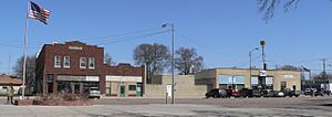
Downtown Duncan: 8th Street west of Main Street, April 2010
|
|

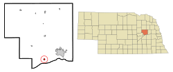
Location of Duncan, Nebraska
|
|
| Country | United States |
| State | Nebraska |
| County | Platte |
| Township | Butler |
| Area | |
| • Total | 0.47 sq mi (1.21 km2) |
| • Land | 0.47 sq mi (1.21 km2) |
| • Water | 0.00 sq mi (0.00 km2) |
| Elevation | 1,496 ft (456 m) |
| Population
(2020)
|
|
| • Total | 392 |
| • Density | 837.61/sq mi (323.56/km2) |
| Time zone | UTC-6 (Central (CST)) |
| • Summer (DST) | UTC-5 (CDT) |
| ZIP code |
68634
|
| Area code(s) | 402 |
| FIPS code | 31-13890 |
| GNIS feature ID | 2398753 |
Duncan is a small village located in Platte County, Nebraska, in the United States. In 2020, about 392 people lived there. It's a quiet place with a rich history, especially linked to the early railroads and immigrant communities.
Contents
History of Duncan
Duncan's story began in 1866 when the first transcontinental railroad line reached this area. Some of the very first people to settle here were immigrants from Poland and Switzerland.
In June 1869, a post office called Cherry Hill was set up in the area. Later, in October 1871, officials from the Union Pacific Railroad planned out the townsite of Jackson. Jackson was chosen in 1879 as an important stop for a railroad branch line.
The settlement's name changed to Duncan in 1880. This was because there was another town named Jackson nearby. The new name honored General Wood B. Duncan, who was a well-known person who used to live in the area.
In 1881, a Baptist church was started in Duncan. The next year, Polish Roman Catholics built St. Stanislaus Church. In 1883, St. Paul's Methodist Episcopal Church was also established. The Village of Duncan officially became an incorporated village in 1913.
Where is Duncan?
Duncan is located in Nebraska, between two rivers: the Loup River and the Platte River. It sits right on U.S. Route 30. It is about 8 miles (13 km) west of the city of Columbus.
The United States Census Bureau says that Duncan covers a total area of about 0.42 square miles (1.09 square kilometers). All of this area is land.
People of Duncan
| Historical population | |||
|---|---|---|---|
| Census | Pop. | %± | |
| 1920 | 182 | — | |
| 1930 | 241 | 32.4% | |
| 1940 | 241 | 0.0% | |
| 1950 | 228 | −5.4% | |
| 1960 | 294 | 28.9% | |
| 1970 | 298 | 1.4% | |
| 1980 | 410 | 37.6% | |
| 1990 | 387 | −5.6% | |
| 2000 | 359 | −7.2% | |
| 2010 | 351 | −2.2% | |
| 2020 | 392 | 11.7% | |
| U.S. Decennial Census | |||
According to the 2010 census, there were 351 people living in Duncan. There were 137 households and 99 families. The village had about 836 people per square mile (323 per square kilometer).
Many households in Duncan were married couples living together. About 31% of households had children under 18 years old. The average age of people in the village was about 39 years old.
What is Duncan's Economy Like?
Duncan's economy is mainly based on farming. People also work in cattle feeding and raising hogs. There are also jobs in manufacturing and retailing (selling goods).
One of the most famous things made in Duncan is Dorothy Lynch salad dressing. In 1964, a company bought the recipe and rights to this dressing. They built a factory in Columbus, Nebraska, and later a bigger, modern plant in Duncan. This plant is now the largest employer in the town.
Culture and Landmarks
Historic Landmarks
You can still see parts of the old Lincoln Highway route in Duncan. This historic road used to go across the country. A special concrete marker shows the start of a 2.4-mile (3.9 km) section of the road. This part hasn't changed much since the 1920s. This section of road, including the marker and some old hackberry trees, is listed in the National Register of Historic Places.
Churches in Duncan
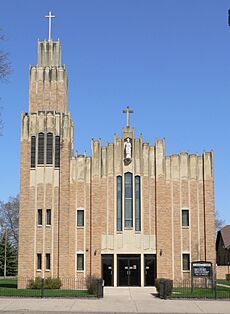
The only church still active in Duncan is St. Stanislaus Catholic Church. The current church building was built in 1939. The name of the church's patron saint is written on the cornerstone in Polish.
Over the years, the church has added new things for its community. A parish center was built in 1979. A group for senior citizens, called the Golden Age Club, started in 1980.
The church also has a youth group for high school students. This group has about 25 members. Once a year, they turn Pulaski Hall into a "Haunted Hall" for Halloween. This is one of their fun ways to raise money.
Fun Festivals
The Duncan Ribfest is a popular two-day summer festival. It usually happens on the last weekend of June. In 2008, about 5,000 people came to the event. Ribfest is the biggest summer event in downtown Duncan.
The festival has live music, including polka, classic rock, and country. Members of the Duncan Fire Department volunteer their time each year. They raise money to help buy new equipment through this event. Duncan Wrestling members also help sponsor the festival.
Transportation in Duncan
Transportation has always been very important to Duncan's history. This is because the village is on a natural route across Nebraska. This route follows the Platte and Loup river valleys.
The village is located on the main line of the Union Pacific Railroad. About 60 freight trains pass through Duncan every day.
In 1913, the famous cross-country Lincoln Highway was built. This highway ran next to the Union Pacific tracks through Duncan. The people of Duncan were very excited about it. The highway went through the center of Duncan until 1928. Then, it was moved to the south side of the tracks. This new route is now used by U.S. Highway 30.
Famous Person from Duncan
- Cory Schlesinger (born 1972) - He is a former NFL fullback and played college football for the Nebraska Cornhuskers.
See also
 In Spanish: Duncan (Nebraska) para niños
 | Selma Burke |
 | Pauline Powell Burns |
 | Frederick J. Brown |
 | Robert Blackburn |


