Dundas, Minnesota facts for kids
Quick facts for kids
Dundas
|
|
|---|---|

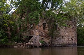
The historic Archibald Mill on the Cannon River in Dundas, June 2008.
|
|
| Motto(s):
"Heaven in MN"
|
|

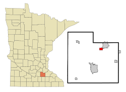
Location of Dundas, Minnesota
|
|
| Country | United States |
| State | Minnesota |
| County | Rice |
| Platted | 1857 |
| Government | |
| • Type | Mayor-council |
| Area | |
| • Total | 1.85 sq mi (4.78 km2) |
| • Land | 1.85 sq mi (4.78 km2) |
| • Water | 0.00 sq mi (0.00 km2) |
| Elevation | 925 ft (282 m) |
| Population
(2020)
|
|
| • Total | 1,712 |
| • Estimate
(2022)
|
1,744 |
| • Density | 926.91/sq mi (357.83/km2) |
| Time zone | UTC−6 (Central (CST)) |
| • Summer (DST) | UTC−5 (CDT) |
| ZIP Code |
55019
|
| Area code(s) | 507 |
| FIPS code | 27-17126 |
| GNIS feature ID | 2394572 |
| Sales tax | 7.375% |
Dundas (/ˈdʌndəs/ DUN-dəss) is a small city in Rice County, Minnesota, United States. In 2020, about 1,712 people lived there. It is located right next to the city of Northfield.
Contents
History of Dundas
Dundas was officially planned out in 1857. This was done by the Archibald brothers, John Sidney and Edward T., and their cousin George Archibald. They built mills on both sides of the Cannon River. The brothers named the city after their home, Dundas County, Ontario, in Canada.
The Archibald Mill
The old Archibald Mill, which was a flour mill, can still be seen today. Its ruins are on the west side of the Cannon River. Milling was very important for Dundas's success in the 1800s. At one point, the mills in Dundas were thought to be among the best in the world.
Dundas's Changing Downtown
The city's first main business area was on Second Street. By 1866, it had two general stores, a library, a hotel, and other shops. But things changed when the Minnesota Central Railway built its station. This new station was on the west side of the river. Because of this, a new area called Railway Street grew up in 1865.
Today, the only building left from the original business district is the Ault Store. It was built in 1866 and started as a general store. The town's first library was on its second floor. This building also housed the Dundas News newspaper for a few years.
The Archibald Mill, the Ault Store, and the Edward T. Archibald House are important historical places. They are listed on the National Register of Historic Places.
Dundas Today
Today, Dundas is mostly a "bedroom community." This means many people who live there travel to work in nearby Northfield or the larger Minneapolis-St. Paul area. Dundas has some businesses that might not be found in Northfield. For example, it has an off-sale liquor store and two bars.
You might hear jokes about "Dundas Technical University" (Dundas Tech). But this university only exists on T-shirts and in jokes!
Dundas also has the only public feed mill in about 40 miles. It is run by Interstate Mills where the first grain elevator used to be. In 1999, there was talk of a Target store being built in Dundas instead of Northfield. This helped Northfield change its rules about what kinds of businesses could be built there. A Union Pacific freight railroad line also goes through Dundas.
Geography of Dundas
Dundas covers an area of about 1.92 square miles (4.97 square kilometers). All of this area is land. The Cannon River flows right through the middle of the city.
Dundas is located at 44.429 degrees North latitude and 93.204 degrees West longitude. Its elevation is 932 feet (284 meters) above sea level.
The main roads in Dundas are Minnesota State Highway 3 and Rice County Road 1. Interstate 35 is also close by.
People of Dundas
| Historical population | |||
|---|---|---|---|
| Census | Pop. | %± | |
| 1880 | 589 | — | |
| 1890 | 554 | −5.9% | |
| 1900 | 493 | −11.0% | |
| 1910 | 357 | −27.6% | |
| 1920 | 373 | 4.5% | |
| 1930 | 377 | 1.1% | |
| 1940 | 456 | 21.0% | |
| 1950 | 469 | 2.9% | |
| 1960 | 488 | 4.1% | |
| 1970 | 460 | −5.7% | |
| 1980 | 422 | −8.3% | |
| 1990 | 473 | 12.1% | |
| 2000 | 547 | 15.6% | |
| 2010 | 1,367 | 149.9% | |
| 2020 | 1,712 | 25.2% | |
| 2022 (est.) | 1,744 | 27.6% | |
| U.S. Decennial Census 2020 Census |
|||
Dundas Population in 2010
In 2010, there were 1,367 people living in Dundas. There were 514 households and 376 families. The city had about 712 people per square mile (275 people per square kilometer). Most people (93.9%) were White. Other groups included African American, Native American, and Asian people. About 4.6% of the population was Hispanic or Latino.
About 38.9% of households had children under 18 living with them. Most households (62.1%) were married couples. The average household had 2.66 people. The average family had 3.08 people.
The average age in Dundas was 33.6 years old. About 27.7% of residents were under 18. About 34.5% were between 25 and 44 years old. The population was almost evenly split between males (50.6%) and females (49.4%).
Images for kids
See also
 In Spanish: Dundas (Minnesota) para niños
 | Selma Burke |
 | Pauline Powell Burns |
 | Frederick J. Brown |
 | Robert Blackburn |


