
Därstetten facts for kids
Quick facts for kids
Därstetten
|
||
|---|---|---|

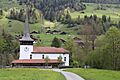
The Moos hamlet in Därstetten.
|
||
|
||

Därstetten
Location in Switzerland

Därstetten
Location in Canton of Bern
|
||
| Country | Switzerland | |
| Canton | Bern | |
| District | Frutigen-Niedersimmental | |
| Area | ||
| • Total | 32.84 km2 (12.68 sq mi) | |
| Elevation | 757 m (2,484 ft) | |
| Population
(Dec 2020 )
|
||
| • Total | 862 | |
| • Density | 26.248/km2 (67.98/sq mi) | |
| Postal code |
3763
|
|
| Surrounded by | Blumenstein, Diemtigen, Erlenbach im Simmental, Oberstocken, Oberwil im Simmental, Pohlern, Rüeggisberg, Rüschegg | |

Därstetten is a small town, also called a municipality, located in the Frutigen-Niedersimmental area of the canton of Bern in Switzerland. It's a peaceful place known for its beautiful natural surroundings.
Contents
History of Därstetten
Därstetten was first mentioned in old writings in 1228. Back then, it was called Tarenchat. A nearby village, Weissenburg, was first noted around 1270.
Long ago, a very old tool from the Neolithic period was found here. This shows people lived in the area even thousands of years ago! During the Middle Ages, the land belonged to a noble family called the Freiherr von Weissenburg. Around the late 1100s, they gave some land by the Simmen river to a group of monks called the Augustinians. A monastery was built there, and it was mentioned in 1228.
Weissenburg Castle was likely built in the mid-1200s. In 1368, another noble family, the Freiherr von Brandis, took over the Weissenburg lands. The monastery grew bigger as nobles gave more land and the monks bought estates. The monastery church became a special burial place for the Freiherr family.
In 1439, the city of Bern gained control of the Weissenburg lands, including the monastery and the village. Later, in 1528, Bern changed its religion to Protestantism. The monastery was closed, and its church became the main church for the local area.
For a long time, the farming communities mostly grew their own food. But starting in the 1500s, they began raising animals to sell to other places. In 1902, a railroad line connected Därstetten to the rest of Switzerland. This helped the villages grow, and the train stations became important centers. Today, Därstetten's economy relies on raising cattle, making cheese, forestry, small businesses, and welcoming tourists.
Geography and Landscape
Därstetten covers an area of about 32.8 square kilometers (about 12.7 square miles). A large part of this land, about 46.2%, is used for farming. Forests cover about 39.9% of the area.
About 2.7% of the municipality has buildings or roads. Rivers and lakes make up about 1.1% of the land. The remaining 10.1% is land that cannot be used for farming or building, like rocky areas.
The town is located in a valley and on hills near the Stockhorn and Turnen mountains. The landscape includes flat valley areas, thick forests, and high alpine pastures. It also includes farming communities called Weissenburg, Reichenbach, and Wiler.
In 2010, Därstetten became part of a new administrative area called Frutigen-Niedersimmental.
Coat of Arms
The coat of arms for Därstetten shows a red background. On it, there is a silver castle with battlements. There is also a silver double rose with green leaves and a yellow center.
People of Därstetten
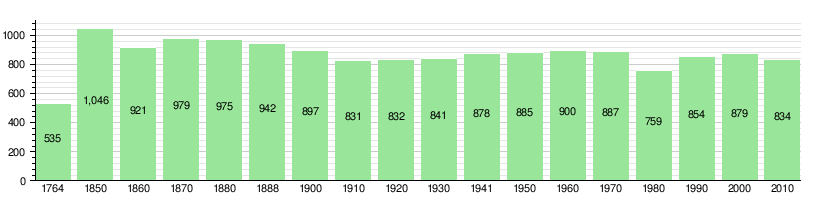
Därstetten has a population of about 822 people (as of December 2011). A small number of people, about 2.8%, are foreign nationals. Over the last ten years, the population has slightly decreased.
Most people in Därstetten, about 96.9%, speak German as their main language. A small number speak French (0.9%) or Albanian (0.7%).
In 2008, the population was almost equally split between males (50.6%) and females (49.4%). Most people living in Därstetten were born either in the town itself or in the same canton.
Young people, aged 0–19, make up about 20.8% of the population. Adults aged 20–64 make up 60.3%, and seniors over 64 make up 18.9%.
Many people in Därstetten are married. There are also single people, widows, and divorced individuals.
The population of Därstetten has changed over time, as shown in the chart below:
Important Heritage Sites
Därstetten has several buildings and areas that are considered important heritage sites. These include three old farmhouses: Nidflue 309, Argel at Zur Obern 161, and the Knuttihaus im Moos at Moos 47.
The small communities of Nidflue and Wiler, the Därstetten Church, and the area around Weissenburg are also part of the Inventory of Swiss Heritage Sites. This means they are protected because of their historical or cultural value.
Economy and Jobs
In 2011, Därstetten had a very low unemployment rate, meaning almost everyone who wanted a job had one. In 2008, there were 358 people working in the municipality.
Jobs in Därstetten are divided into three main types:
- Primary sector: This includes jobs like farming and forestry. About 155 people worked in this area.
- Secondary sector: This involves making things, like in factories or construction. About 78 people worked here.
- Tertiary sector: These are service jobs, like working in shops, hotels, or healthcare. About 125 people worked in this sector.
Many people who live in Därstetten also work there. However, more people leave Därstetten to work in other towns than people who come into Därstetten for work. Most workers use a private car to get to their jobs.
Religion
According to a census in 2000, most people in Därstetten, about 85%, belonged to the Swiss Reformed Church. About 5.3% were Roman Catholic.
There were also smaller numbers of people who belonged to other Christian churches, Islam, or Hinduism. Some people did not belong to any church or preferred not to say.
Transportation
Därstetten is connected by the Spiez–Zweisimmen railway line. This means you can travel by train to and from Därstetten. The town has two train stations: Därstetten station and Weissenburg railway station station.
Education
In Därstetten, about 53.4% of adults have finished high school (non-mandatory upper secondary education). About 8.9% have gone on to higher education, like university.
The school system in the Canton of Bern starts with one year of optional Kindergarten. After that, students go to six years of Primary school. Then, they attend three years of lower Secondary school, where they are grouped by their abilities. After lower Secondary, students can continue their education or start an apprenticeship (learning a trade on the job).
During the 2011-2012 school year, there were 93 students attending schools in Därstetten. This included one kindergarten class, three primary classes, and one lower secondary class. Most students who live in Därstetten also go to school there.
See also
 In Spanish: Därstetten para niños
Images for kids
-
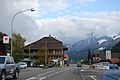
Därstetten municipality and surrounding mountains
-
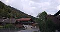
Houses in Därstetten
-
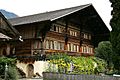
Knuttihaus im Moos
-
Reformed church Därstetten


