
Pohlern facts for kids
Quick facts for kids
Pohlern
|
||
|---|---|---|

The Farm House in Rohrmoos, a Swiss Heritage Site
|
||
|
||

Pohlern
Location in Switzerland

Pohlern
Location in Canton of Bern
|
||
| Country | Switzerland | |
| Canton | Bern | |
| District | Thun | |
| Area | ||
| • Total | 9.87 km2 (3.81 sq mi) | |
| Elevation | 710 m (2,330 ft) | |
| Population
(Dec 2020 )
|
||
| • Total | 232 | |
| • Density | 23.51/km2 (60.88/sq mi) | |
| Postal code |
3638
|
|
| Surrounded by | Därstetten, Oberstocken, Höfen, Übeschi, and Blumenstein. | |

Pohlern is a small town, also called a municipality, in Switzerland. It is located in the canton of Bern, within the Thun area.
Contents
History of Pohlern
Pohlern was first mentioned in old records in the year 1389. Back then, it was called in der Polleren.
For a long time, Pohlern was mostly a forest with very few people living there. This was during the Late Middle Ages. It was part of a larger area ruled by a lord, called a Herrschaft, named Strättligen. In the 1300s, people slowly started to settle in Pohlern. This happened under the rule of the Freiherr (a type of noble lord) von Burgistein.
By 1417, a group of monks called the Barfüsser (who were Franciscan monks) from a monastery in Bern owned some land and rights in Pohlern. Later, in 1459, Pohlern was joined with a nearby town called Uebeschi to form a new Herrschaft of Pohlern.
In 1499 and again in 1516, a powerful family from Bern called the May family bought parts of the village. In 1528, Bern changed its main religion to Protestantism. Because of this, all monasteries, including the Barfüsser one, were closed down. Bern then took control of Pohlern and ended its Herrschaft status. Pohlern became part of the Amsoldingen court, which was in the Thun District. It stayed this way until 2009. Today, most people in Pohlern either work in farming or travel to jobs outside the town.
For most of its history, Pohlern was part of the church area of Thierachern. In 1922, it was moved to the church area of Blumenstein, which is closer. Pohlern also shares a school building with Blumenstein.
Geography of Pohlern
Pohlern covers an area of about 10.67 square kilometers (4.12 square miles). A large part of this land is used for farming, about 37.4%. Forests cover an even bigger part, about 45.3%. The town itself, with buildings and roads, takes up about 1.9% of the land. Rivers and lakes make up 1.5%, and about 14.4% of the land cannot be used for farming or building.
The town is located on the northern side of the Stockhorn mountains, at the lower end of the Stockental valley. Like most of the Bern canton, people in Pohlern speak German.
On December 31, 2009, the old administrative area of Thun was closed. The very next day, January 1, 2010, Pohlern became part of the new Verwaltungskreis Thun.
Pohlern's Coat of Arms
A coat of arms is a special design that represents a town or family. Pohlern's coat of arms shows a green fir tree with a red trunk and roots. It stands on three black hills. The background color is silver.
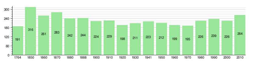
People and Population
Pohlern has a population of 232 people. As of 2012, about 5.3% of the people living in Pohlern are not Swiss citizens. Between 2010 and 2012, the population slightly decreased.
Most people in Pohlern speak German as their main language. As of 2000, 100% of the population spoke German.
In 2008, about 54.3% of the population was male and 45.7% was female. Most of the people living in Pohlern were born in Switzerland. About 31.4% were born in Pohlern itself.
As of 2012, children and teenagers (ages 0-19) make up 24.0% of the population. Adults (ages 20-64) make up 58.9%, and seniors (over 64 years old) make up 17.1%.
The chart below shows how Pohlern's population has changed over many years:
Economy and Jobs
In 2011, Pohlern had a very low unemployment rate of 0.24%. This means almost everyone who wanted a job had one.
There are different types of jobs in Pohlern:
- Primary sector: This includes jobs like farming. In 2011, 31 people worked in this area.
- Secondary sector: This includes jobs like manufacturing (making things) and construction (building things). In 2011, 11 people worked here.
- Tertiary sector: This includes jobs in services, like hotels, restaurants, education, and healthcare. In 2011, 26 people worked in this sector.
Many people who live in Pohlern travel to other towns for work. In 2000, 99 people commuted out of Pohlern for their jobs, while only 13 came into Pohlern to work. Most people (61.3%) use a private car to get to work.
Pohlern has some of the lowest local and canton (state) tax rates in Bern. For example, in 2012, a married person with two children earning 150,000 CHF paid about 12.2% in taxes. An unmarried person paid about 18.2%. These rates are lower than the average for the whole canton.
Important Heritage Sites

Pohlern has two special buildings that are listed as Swiss heritage sites of national significance. This means they are very important historical places. They are:
- The farm house in Rohrmoos at Rohrmooshof 3.
- The farm house Mättli at Mettli 23.
Religion in Pohlern
Based on the 2000 census, most people in Pohlern belong to the Swiss Reformed Church, about 87.2%. A smaller number, 1.3%, are Roman Catholic. Some people belong to other Christian churches. About 4.42% of the population said they did not belong to any church, meaning they might be agnostic (unsure about God) or atheist (do not believe in God).
Education System
In Pohlern, about 53.5% of the people have finished non-mandatory upper secondary education. This is like high school. About 11.6% have gone on to higher education, like a university or a specialized college.
The school system in the Canton of Bern works like this:
- One year of non-required Kindergarten.
- Six years of Primary school.
- Three years of required lower Secondary school. In this stage, students are grouped based on their abilities.
- After lower Secondary, students can choose to continue their schooling or start an apprenticeship (learning a trade on the job).
During the 2012–13 school year, 24 students attended classes in Pohlern. There were 54 students in German language kindergarten classes. The primary school had 24 students in German language classes. Some students also attend private or special schools.
In 2000, 15 students lived and went to school in Pohlern. One student came from another town to study in Pohlern. Also, 12 students from Pohlern went to schools outside the municipality.
See also
 In Spanish: Pohlern para niños
