
Early Indian treaty territories in Montana facts for kids
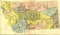
Native American tribes living in what is now Montana signed many treaties with the United States in the 1800s. These agreements often set up the land areas for each tribe. Over time, more and more of this Native American land became U.S. territory as new treaties were signed. You can see these changes on maps.

Understanding Early Treaties in Montana
Treaties are like big agreements between different groups. In the 1800s, the U.S. government made many treaties with Native American tribes. These treaties often decided who owned which land.
Assiniboine Lands and Treaties
The Assiniboine tribe had a large territory defined by the Treaty of Fort Laramie (1851). This land later became U.S. territory in 1875. The Assiniboine had tried to give up this land in an earlier treaty in 1866, but that treaty was never officially approved.
Flathead, Kootenay, and Pend d'Oreille Territories
The "Flathead, Kootenay and Upper Pend d'Oreille" tribes used a specific area. The Kootenai and Upper Pend d'Oreille (also known as Kalispel) lived north of Flathead Lake. The Flathead (Salish) camped in the valley south of the lake. A smaller area, called the "Jocko Reserve," was created for them by the Hellgate treaty in 1855.
Blackfeet Nation Lands and Agreements
The Blackfeet Indians and their allies, the Gros Ventre tribe, hunted and lived in a large area. The Treaty of Fort Laramie (1851) described a big part of this land as Blackfoot territory. This was a bit unusual because the Blackfeet didn't actually attend the treaty meetings.
Later, in 1855, some of this land became shared hunting grounds for 99 years. The Blackfeet agreed to let the Flathead, Upper Pend d'Oreille, Kootenay, and Nez Perce tribes, as well as white settlers, use these areas. They also allowed the Assiniboine to hunt on a part of their eastern land.
Over time, more of the Blackfeet's original treaty land was given up. Today, several reservations are located within this former Blackfeet territory. These include the Blackfeet Reservation, the Rocky Boy Indian Reservation, the Fort Belknap Indian Reservation, and the Fort Peck Indian Reservation.
Crow Nation Territory Changes
The Crow Indian territory in Montana was set by the Treaty of Fort Laramie (1851). Later, a smaller area became the Crow Indian Reservation in 1868.
Lands of the Arikara, Hidatsa, and Mandan Tribes
The western part of the land belonging to the Arikara, Hidatsa, and Mandan tribes was also defined by the Treaty of Fort Laramie (1851). The United States gained control of these lands through special orders in 1870 and 1880.
Lakota Territory in Montana
The bottom right of the map shows the edges of a larger Lakota territory. This land was mainly in what is now North and South Dakota and Wyoming, as described in the Treaty of Fort Laramie (1851).
The Northern Cheyennes and Their Arrival
The Northern Cheyennes are not mentioned in these early treaties because they arrived in Montana later. Along with the Northern Arapahos and the Lakotas, they moved into Montana during the Sioux Wars in the mid-1860s and 1870s. Today, the western part of the Northern Cheyenne Indian Reservation is next to the Crow reservation.
Chippewas and Crees in Montana
The Chippewas and the Crees are other Native American groups who did not have a long history in Montana. The Rocky Boy Indian Reservation is located in the middle of what was once a larger Blackfeet treaty area.
Images for kids
-
Map with Indian territories in Montana

