East Fishkill, New York facts for kids
Quick facts for kids
East Fishkill, New York
|
||
|---|---|---|

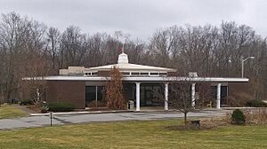
Town hall, on NY Route 376 south of Hopewell Junction
|
||
|
||

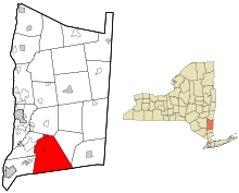
Location of East Fishkill, New York
|
||
| Country | United States | |
| State | New York | |
| County | Dutchess | |
| Established | 1849 | |
| Government | ||
| • Type | Town Council | |
| Area | ||
| • Total | 57.39 sq mi (148.63 km2) | |
| • Land | 56.50 sq mi (146.35 km2) | |
| • Water | 0.88 sq mi (2.29 km2) | |
| Elevation | 289 ft (88 m) | |
| Population
(2010)
|
||
| • Total | 29,029 | |
| • Density | 521.01/sq mi (201.16/km2) | |
| Time zone | UTC-5 (Eastern (EST)) | |
| • Summer (DST) | UTC-4 (EDT) | |
| ZIP Codes |
12533, 12590, 12582 (There is no ZIP for East Fishkill. USPS addressing is split between Hopewell Junction, Stormville and Wappingers Falls)
|
|
| Area code(s) | 845 | |
| FIPS code | 36-027-21996 | |
| GNIS feature ID | 0978917 | |
East Fishkill is a town located in Dutchess County, New York, in the United States. It sits on the southern border of the county. In 2020, about 29,707 people lived there. Before 1849, East Fishkill was just the eastern part of another town called Fishkill.
A big research center called Hudson Valley Research Park is in the town. This place used to be known as IBM East Fishkill. It was a major site for IBM, where they made microchips. It also had an advanced factory that helped create the "Cell" processor. Now, a company called Onsemi owns the factory.
Contents
History of East Fishkill

Long ago, a Native American group called the Wiccopee lived in this area. They were part of the larger Wappinger tribe. One of the first European settlers arrived around 1759.
A famous person named Platt Rogers Spencer was born here in 1800. He created a popular handwriting style used in businesses during the 1800s.
The town of East Fishkill was officially created in 1849. It was formed from the eastern part of the original town of Fishkill. The name "Fishkill" comes from the Dutch words Vis Kille, which means "Fish Creek."
Geography and Location
East Fishkill covers about 148.6 square kilometers (57.4 square miles). Most of this area is land, with a small part being water.
The town shares its borders with several other towns:
- To the west: Fishkill and Wappinger
- To the north: LaGrange
- To the east: Beekman and Pawling
- To the south: Philipstown and Kent, which are in Putnam County
Important roads and trails pass through East Fishkill. These include Interstate 84, the Appalachian Trail, and the Taconic State Parkway.
East Fishkill's Climate
East Fishkill has a climate with warm summers and cold winters. This type of climate is called a "hot-summer humid continental climate." The hottest temperature ever recorded here was 101°F (38°C) on August 9, 2001. The coldest temperature was -22°F (-30°C) on January 27, 1994.
| Climate data for Stormville, New York, 1991–2020 normals, extremes 1990–2007 | |||||||||||||
|---|---|---|---|---|---|---|---|---|---|---|---|---|---|
| Month | Jan | Feb | Mar | Apr | May | Jun | Jul | Aug | Sep | Oct | Nov | Dec | Year |
| Record high °F (°C) | 67 (19) |
68 (20) |
90 (32) |
95 (35) |
96 (36) |
93 (34) |
100 (38) |
101 (38) |
92 (33) |
85 (29) |
77 (25) |
71 (22) |
101 (38) |
| Mean daily maximum °F (°C) | 35.4 (1.9) |
38.9 (3.8) |
48.6 (9.2) |
61.4 (16.3) |
71.7 (22.1) |
77.1 (25.1) |
83.1 (28.4) |
81.8 (27.7) |
74.3 (23.5) |
62.8 (17.1) |
50.4 (10.2) |
39.3 (4.1) |
60.4 (15.8) |
| Daily mean °F (°C) | 26.2 (−3.2) |
29.0 (−1.7) |
37.6 (3.1) |
49.5 (9.7) |
60.1 (15.6) |
67.4 (19.7) |
73.0 (22.8) |
71.9 (22.2) |
64.4 (18.0) |
53.0 (11.7) |
41.3 (5.2) |
31.5 (−0.3) |
50.4 (10.2) |
| Mean daily minimum °F (°C) | 17.0 (−8.3) |
19.1 (−7.2) |
26.6 (−3.0) |
37.5 (3.1) |
48.5 (9.2) |
57.7 (14.3) |
63.0 (17.2) |
62.0 (16.7) |
54.5 (12.5) |
43.2 (6.2) |
32.3 (0.2) |
23.6 (−4.7) |
40.4 (4.7) |
| Record low °F (°C) | −22 (−30) |
−11 (−24) |
−2 (−19) |
15 (−9) |
31 (−1) |
40 (4) |
47 (8) |
46 (8) |
32 (0) |
26 (−3) |
11 (−12) |
−1 (−18) |
−22 (−30) |
| Average precipitation inches (mm) | 3.72 (94) |
3.42 (87) |
3.95 (100) |
3.82 (97) |
3.62 (92) |
4.48 (114) |
4.36 (111) |
3.75 (95) |
5.07 (129) |
4.71 (120) |
3.90 (99) |
4.14 (105) |
48.94 (1,243) |
| Average snowfall inches (cm) | 14.3 (36) |
12.9 (33) |
14.3 (36) |
3.1 (7.9) |
0.0 (0.0) |
0.0 (0.0) |
0.0 (0.0) |
0.0 (0.0) |
0.0 (0.0) |
0.0 (0.0) |
2.1 (5.3) |
11.2 (28) |
57.9 (146.2) |
| Average precipitation days (≥ 0.01 in) | 13.0 | 9.9 | 12.7 | 12.5 | 12.5 | 11.4 | 10.6 | 10.3 | 10.1 | 9.2 | 10.6 | 11.1 | 133.9 |
| Average snowy days (≥ 0.1 in) | 8.7 | 5.9 | 5.6 | 1.3 | 0.0 | 0.0 | 0.0 | 0.0 | 0.0 | 0.1 | 1.4 | 5.2 | 28.2 |
| Source 1: NOAA | |||||||||||||
| Source 2: XMACIS2 | |||||||||||||
People of East Fishkill
| Historical population | |||
|---|---|---|---|
| Census | Pop. | %± | |
| 1850 | 2,610 | — | |
| 1860 | 2,544 | −2.5% | |
| 1870 | 2,305 | −9.4% | |
| 1880 | 2,574 | 11.7% | |
| 1890 | 2,175 | −15.5% | |
| 1900 | 1,970 | −9.4% | |
| 1910 | 2,226 | 13.0% | |
| 1920 | 1,944 | −12.7% | |
| 1930 | 1,845 | −5.1% | |
| 1940 | 2,024 | 9.7% | |
| 1950 | 2,565 | 26.7% | |
| 1960 | 4,778 | 86.3% | |
| 1970 | 11,092 | 132.1% | |
| 1980 | 18,091 | 63.1% | |
| 1990 | 22,101 | 22.2% | |
| 2000 | 25,589 | 15.8% | |
| 2010 | 29,029 | 13.4% | |
| 2020 | 29,707 | 2.3% | |
| U.S. Decennial Census | |||
In 2000, there were about 25,589 people living in East Fishkill. There were 8,233 households, with 7,006 of them being families. The population density was about 449.7 people per square mile.
Most of the people in East Fishkill were White (92.54%). There were also African American (2.29%), Native American (0.15%), and Asian (2.8%) residents. About 4.04% of the population was Hispanic or Latino.
Many households (45.8%) had children under 18 living with them. Most households (75.7%) were married couples. The average household had 3.10 people, and the average family had 3.38 people.
The population included:
- 29.7% under 18 years old
- 6.4% from 18 to 24 years old
- 30.4% from 25 to 44 years old
- 25.5% from 45 to 64 years old
- 8.0% who were 65 years or older
The average age in the town was 37 years. The average income for a household was $116,059, and for a family, it was $129,660. A small number of families (1.5%) and people (2.8%) lived below the poverty line.
Communities and Hamlets
East Fishkill has several smaller communities and hamlets within its borders:
- Fishkill Plains – A small community in the northwest part of the town.
- Gayhead – Located just outside of Hopewell Junction.
- Hillside Lake – Found northeast of Fishkill Plains.
- Hopewell Junction – A hamlet also in the northwestern part of the town.
- Hortontown – A community in the eastern section of town.
- Leetown – An area on top of Stormville Mountain, named after early settlers.
- Lomala – A hamlet south of Hopewell Junction.
- Pecksville – A community in the southeastern corner of the town.
- Shenandoah – Also known as Shenandoah Corners, this hamlet is in the southern part of the town. It's near Interstate 84, the Taconic State Parkway, and the Appalachian Trail.
- Stormville – A hamlet in the eastern part of the town. It was named after early settlers, brothers Jacob and Rupert Storm.
- Wiccopee – This hamlet is near the western town line. It used to be called Johnsville from about 1800 to 1904. The area of Fishkill Hook is part of Wiccopee.
See also
 In Spanish: East Fishkill para niños
 | John T. Biggers |
 | Thomas Blackshear |
 | Mark Bradford |
 | Beverly Buchanan |


