East Fork Millicoma River facts for kids
Quick facts for kids East Fork Millicoma River |
|
|---|---|

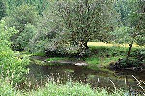
Downstream of Nesika County Park
|
|
|
Location of the mouth of the East Fork Millicoma River in Oregon
|
|
| Country | United States |
| State | Oregon |
| County | Coos |
| Physical characteristics | |
| Main source | eastern Coos County near Douglas County line, Southern Oregon Coast Range 1,921 ft (586 m) 43°24′50″N 123°46′04″W / 43.41389°N 123.76778°W |
| River mouth | Millicoma River Allegany 20 ft (6.1 m) 43°25′27″N 124°01′49″W / 43.42417°N 124.03028°W |
| Length | 24 mi (39 km) |
The East Fork Millicoma River is a river in Oregon, a state in the United States. It flows for about 24 miles (39 km) through Coos County. This river is an important part of a larger river system that eventually reaches the Pacific Ocean.
The East Fork Millicoma River starts in the eastern part of Coos County. It begins in the Southern Oregon Coast Range mountains, near a place called Ivers Peak. From there, it flows generally west.
Where Does the River Go?
The East Fork Millicoma River joins another river, the West Fork Millicoma River, near the town of Allegany. When these two rivers meet, they form the main Millicoma River.
The Millicoma River's Journey
The Millicoma River is about 9 miles (14 km) long. It then flows into the South Fork Coos River. Together, they create the Coos River. The Coos River is about 5 miles (8 km) long and empties into the eastern end of Coos Bay. Coos Bay is a large natural harbor that connects to the Pacific Ocean. So, the water from the East Fork Millicoma River travels a long way to reach the ocean!
What Creeks Join the River?
As the East Fork Millicoma River flows, many smaller streams and creeks join it. These are called tributaries.
- About 18 miles (29 km) from where it ends, Beulah Creek flows into the river from the right side.
- Further downstream, Little Matson Creek also joins from the right.
- A little later, Fox Creek enters from the left side.
- Glenn Creek joins the river from the right about 7 miles (11 km) from its end.
Golden and Silver Falls
One of the most interesting parts of the river's journey involves Glenn Creek. Glenn Creek and one of its smaller streams, Silver Creek, create two beautiful waterfalls. These are called Golden Falls and Silver Falls. You can see them in the Golden and Silver Falls State Natural Area.
Other Important Creeks
- Rodine Creek flows into the river from the left side.
- Hodges Creek also enters from the left, just past Nesika County Park.
- Closer to Allegany, Marlow Creek and then Nowlit Creek join the river from the right side.
East Fork Millicoma Road runs alongside the river for much of its path. This road makes it easy to see the river as it flows.
Wildlife and Recreation
The East Fork Millicoma River is home to different types of fish.
- Coastal cutthroat trout: These fish live in the river all year round.
- Winter steelhead: These are a type of rainbow trout that swim up the river from the ocean during the winter months to lay their eggs.
Fishing at Nesika County Park
If you like fishing, Nesika County Park is a great spot. It's about 2.5 miles (4 km) east of Allegany, right on East Fork Millicoma Road. The park offers easy access to the riverbanks, which is perfect for catching steelhead.
 | Percy Lavon Julian |
 | Katherine Johnson |
 | George Washington Carver |
 | Annie Easley |


