East Lake Abert Archeological District facts for kids
Quick facts for kids |
|
|
East Lake Abert Archeological District
|
|

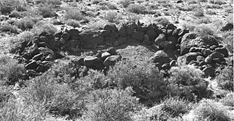
Prehistoric stone house ring
|
|
| Location | Lake County, Oregon, U.S. Address restricted |
|---|---|
| Built | Over the past 11,000 years |
| Architectural style | Prehistoric house pits and rock art |
| NRHP reference No. | 78002295 |
| Added to NRHP | 29 November 1978 |
The East Lake Abert Archeological District is a special place in Lake County, Oregon, United States. It's famous for many ancient camp sites and amazing rock carvings called petroglyphs. This area is found along the eastern shore of Lake Abert. It's managed by the Bureau of Land Management and the Oregon Department of Transportation.
The district has old stone house pits and prehistoric rock art. These were made by ancient Native Americans. They lived here for about 11,000 years! Because of its unique history and cultural importance, the East Lake Abert Archeological District was added to the National Register of Historic Places in 1978. This means it's a very important historical site.
Ancient Times at Lake Abert
After the last Ice Age ended, a lot of melted ice filled up basins in what is now south-central Oregon. This created huge lakes called pluvial lakes. These lakes covered much of Oregon's high desert area, including the land around Lake Abert.
During this time, large animals like mammoths, bison, horses, camels, and mountain sheep lived here. These many animals attracted ancient hunters to the area.
About 7,500 years ago, the weather changed. The big pluvial lakes started to shrink. As the lakes got smaller, animals like mammoths, horses, and camels disappeared. But the area around Lake Abert still had lots of small mammals and many kinds of waterfowl. So, ancient people kept living around Lake Abert.
We don't know much about these early people. But we know they camped, built villages, and carved petroglyphs on rocks along the east shore of Lake Abert. They lived here for about 11,000 years! Over this long time, more people lived here than almost anywhere else in the northern Great Basin region.
Discovering the Past
Experts have studied the eastern shore of Lake Abert twice. The first study happened between 1932 and 1935 by Luther Cressman. Later, in 1975 and 1976, David L. Cole and Richard M. Pettigrew from the University of Oregon did another study. They did this before a highway project to move a part of U.S. Route 395. This highway runs along the eastern shore of Lake Abert.
These studies found many important things. They found house pits, tools, petroglyphs, and pictographs. In 1985, a team from the University of Oregon wrote a full report about all the known ancient sites around Lake Abert.
The sites at Lake Abert show that people lived here for at least 11,000 years. Archeologists have divided this long history into different time periods. The oldest is the Initial Archaic period, from 11,000 to 7,000 years ago. During this time, people used special spear points called Great Basin stemmed projectile points. Later periods also have different types of tools and points that help experts understand when people lived there.
Because the ancient house pits and rock art along Lake Abert are so valuable and are on government land, they are protected. This area is called an "Area of Critical Environmental Concern." This helps make sure these important cultural treasures are kept safe.
The East Lake Abert Archeological District was added to the National Register of Historic Places on November 29, 1978. The Bureau of Land Management has mapped and photographed the sites. This helps them keep track of how the sites change over time. Volunteers from the Archaeological Society of Central Oregon also help watch over the site.
Ancient Homes
The first studies found 32 ancient sites along a 12-mile (19 km) stretch of Lake Abert's eastern shore. These sites include 21 village areas with at least 371 house pits. Fifty-one of these are round house pits made with stone walls. Five other sites had old tools and trash, but no house pits. The last six sites were groups of petroglyphs. By 1990, experts had found 280 more sites!
Today, over 580 house pits and 70 rock rings have been found at Lake Abert. Many of these sites also have old fire pits, grinding stones for food, and broken stone tools. There are not many house pits from the very oldest periods. Most of the villages were built during the Middle Archaic period, meaning they are from the last 4,000 years.
Rock Art
The East Lake Abert Archeological District has six main groups of rock art. There are also many single petroglyphs and pictographs spread throughout the area. All of this rock art is found on loose boulders that have rolled down from Abert Rim. During the two main studies, many petroglyphs and 92 pictographs were recorded. Some designs even mix both petroglyph and pictograph styles.
The rock art shows both animals and geometric shapes. Some animal figures include snakes, lizards, and horned toads. Some snakes clearly look like rattlesnakes because you can see their rattles in the design. The geometric designs include circles, loops, wavy lines, and other more complex patterns.
Where is it?
The East Lake Abert Archeological District is in Lake County, Oregon. The district covers about 300 acres (120 ha) of land. This land belongs to the Bureau of Land Management and the Oregon Department of Transportation. It stretches along a 12-mile (19 km) section of U.S. Route 395. This part of the highway is between the small town of Valley Falls and the north end of Lake Abert.
Some of the house pits and petroglyphs are close to the highway. However, there are no signs or markers to point out the historic district. This helps keep these fragile ancient sites safe from harm.

