Eastampton Township, New Jersey facts for kids
Quick facts for kids
Eastampton Township, New Jersey
|
||
|---|---|---|
|
Township
|
||
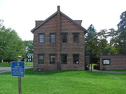
Old schoolhouse within the Smithville Historic District in Eastampton Township
|
||
|
||
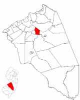
Location of Eastampton Township in Burlington County highlighted in red (right). Inset map: Location of Burlington County in New Jersey highlighted in red (left).
|
||
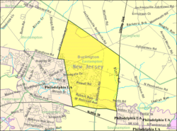
Census Bureau map of Eastampton Township, New Jersey
|
||
| Country | ||
| State | ||
| County | ||
| Incorporated | March 9, 1880 | |
| Government | ||
| • Type | Faulkner Act (council–manager) | |
| • Body | Township Council | |
| Area | ||
| • Total | 5.82 sq mi (15.06 km2) | |
| • Land | 5.73 sq mi (14.84 km2) | |
| • Water | 0.09 sq mi (0.22 km2) 1.48% | |
| Area rank | 261st of 565 in state 26th of 40 in county |
|
| Elevation | 46 ft (14 m) | |
| Population
(2020)
|
||
| • Total | 6,191 | |
| • Estimate
(2023)
|
6,438 | |
| • Rank | 340th of 565 in state 27th of 40 in county |
|
| • Density | 1,080.5/sq mi (417.2/km2) | |
| • Density rank | 373rd of 565 in state 23rd of 40 in county |
|
| Time zone | UTC−05:00 (Eastern (EST)) | |
| • Summer (DST) | UTC−04:00 (Eastern (EDT)) | |
| ZIP Code |
08060 – Mount Holly
|
|
| Area code(s) | 609 | |
| FIPS code | 3400518790 | |
| GNIS feature ID | 0882105 | |
Eastampton Township is a community located in Burlington County, in the U.S. state of New Jersey. It's part of the larger Philadelphia area, which includes cities like Reading and Camden. In 2020, about 6,191 people lived in Eastampton. This was a small increase from the 2010 population.
Contents
History of Eastampton
Eastampton Township officially became a township on February 11, 1880. It was formed from parts of a nearby town called Westampton. A couple of years later, in 1882, some land from Lumberton Township and Southampton Township was added to Eastampton.
One interesting historical spot in Eastampton is Smithville. This was once an industrial community built by Hezekiah Bradley Smith. He owned a machine company that made the "American Star Bicycle." Today, Smithville is a county park where you can explore its history.
Geography and Location
Eastampton Township covers about 5.82 square miles (15.06 square kilometers) of land and water. Most of this area, about 5.73 square miles (14.84 square kilometers), is land.
Eastampton shares its borders with several other towns in Burlington County. These include Lumberton Township, Mount Holly Township, Pemberton Township, Southampton Township, Springfield Township, and Westampton Township.
Besides Smithville, another named area within the township is Turpentine.
Population and People
| Historical population | |||
|---|---|---|---|
| Census | Pop. | %± | |
| 1880 | 566 | — | |
| 1890 | 654 | 15.5% | |
| 1900 | 584 | −10.7% | |
| 1910 | 508 | −13.0% | |
| 1920 | 539 | 6.1% | |
| 1930 | 503 | −6.7% | |
| 1940 | 498 | −1.0% | |
| 1950 | 692 | 39.0% | |
| 1960 | 1,402 | 102.6% | |
| 1970 | 2,284 | 62.9% | |
| 1980 | 3,814 | 67.0% | |
| 1990 | 4,962 | 30.1% | |
| 2000 | 6,202 | 25.0% | |
| 2010 | 6,069 | −2.1% | |
| 2020 | 6,191 | 2.0% | |
| 2023 (est.) | 6,438 | 6.1% | |
| Population sources: 1880–2000 1880–1920 1880–1890 1890–1910 1850–1930 1940–2000 2000 2010 2020 |
|||
In 2010, Eastampton Township had 6,069 people living there. The population was made up of people from many different backgrounds. About 73% were White, 17% were Black or African American, and about 4.5% were Asian. Around 8% of the population identified as Hispanic or Latino.
The average age of people in Eastampton in 2010 was 38 years old. About 24.5% of the population was under 18 years old.
Education in Eastampton
Students in Eastampton Township attend public schools based on their grade level.
Elementary and Middle School
For students from kindergarten through eighth grade, they go to the Eastampton Township School District. There is one school in the district, the Eastampton Community School. In the 2022-23 school year, about 584 students were enrolled there.
High School
Students in ninth through twelfth grade attend Rancocas Valley Regional High School. This high school serves students from five different communities, including Eastampton Township. The school is located in Mount Holly. In the 2022-23 school year, about 1,981 students attended this high school.
Vocational and Technical Schools
Students from Eastampton Township can also choose to attend the Burlington County Institute of Technology. This is a special public school district for the entire county. It offers vocational and technical education for high school students and adults. It has campuses in Medford and Westampton Township.
Transportation
Eastampton Township has about 30.46 miles of roads. Most of these roads are maintained by the township itself.
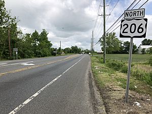
The main highway that goes through Eastampton is U.S. Route 206. It runs north and south along the border with Pemberton Township. Another important road is County Route 537, which crosses the township from east to west.
Notable People from Eastampton
Eastampton Township has been home to some interesting people:
- Charles R. Chickering (1891–1970): He was a freelance artist who designed many U.S. postage stamps. He created 77 different stamp designs!
- Hezekiah Bradley Smith (1816–1887): He was an inventor and a politician. He is known for creating the industrial community of Smithville in Eastampton, where his machine company made bicycles. He also served in the U.S. House of Representatives.
See also
 In Spanish: Municipio de Eastampton para niños


