
Eastern Heights, Queensland facts for kids
Quick facts for kids Eastern HeightsIpswich, Queensland |
|||||||||||||||
|---|---|---|---|---|---|---|---|---|---|---|---|---|---|---|---|

Jim Donald Park, 2023
|
|||||||||||||||

Eastern Heights
Location in Queensland
|
|||||||||||||||
| Population | 3,631 (2021 census) | ||||||||||||||
| • Density | 2,140/km2 (5,500/sq mi) | ||||||||||||||
| Postcode(s) | 4305 | ||||||||||||||
| Area | 1.7 km2 (0.7 sq mi) | ||||||||||||||
| Time zone | AEST (UTC+10:00) | ||||||||||||||
| Location |
|
||||||||||||||
| LGA(s) | City of Ipswich | ||||||||||||||
| State electorate(s) | Ipswich | ||||||||||||||
| Federal Division(s) | Blair | ||||||||||||||
|
|||||||||||||||
<mapframe latitude="-27.6268" longitude="152.7736" zoom="14" width="300" height="250" align="right">
{ "type": "FeatureCollection", "features": [ { "type": "Feature", "id": 910, "geometry": { "type": "Polygon", "coordinates": [ [ [ 152.775029622, -27.63317816 ], [ 152.775050774, -27.633053564 ], [ 152.775327891, -27.631420262 ], [ 152.775382884, -27.631096058 ], [ 152.77586922, -27.628228925 ], [ 152.77590166, -27.628037706 ], [ 152.776033707, -27.628055535 ], [ 152.77699858, -27.628185794 ], [ 152.777325213, -27.628230214 ], [ 152.777926773, -27.62831077 ], [ 152.778168187, -27.628343545 ], [ 152.779891372, -27.628577545 ], [ 152.780217752, -27.628620856 ], [ 152.780700423, -27.628686525 ], [ 152.780919045, -27.628716245 ], [ 152.781692803, -27.62882147 ], [ 152.781929575, -27.628853709 ], [ 152.782600641, -27.628944948 ], [ 152.782819271, -27.628974676 ], [ 152.784130193, -27.629153155 ], [ 152.784362346, -27.62918511 ], [ 152.784863107, -27.629252076 ], [ 152.784878038, -27.629163526 ], [ 152.784937307, -27.628819548 ], [ 152.784769095, -27.628796719 ], [ 152.784600809, -27.628773898 ], [ 152.784432612, -27.628751069 ], [ 152.784264326, -27.628728241 ], [ 152.784498088, -27.627371833 ], [ 152.784560047, -27.627012521 ], [ 152.784617104, -27.626936749 ], [ 152.784595996, -27.626803502 ], [ 152.784631409, -27.626597628 ], [ 152.784659192, -27.62643607 ], [ 152.784686975, -27.626274519 ], [ 152.784714773, -27.62611296 ], [ 152.784742549, -27.625951402 ], [ 152.78477034, -27.625789851 ], [ 152.784798123, -27.6256283 ], [ 152.784825906, -27.625466749 ], [ 152.784853689, -27.625305191 ], [ 152.784878351, -27.625281014 ], [ 152.784862958, -27.625251338 ], [ 152.784890741, -27.625089787 ], [ 152.784918524, -27.624928229 ], [ 152.784946144, -27.624767646 ], [ 152.784690216, -27.624732859 ], [ 152.784466244, -27.624702349 ], [ 152.784335032, -27.624684468 ], [ 152.784064814, -27.624647595 ], [ 152.782925203, -27.624492191 ], [ 152.78267552, -27.624458067 ], [ 152.781128839, -27.624246515 ], [ 152.778883874, -27.623939827 ], [ 152.778783433, -27.623925976 ], [ 152.778844513, -27.623573549 ], [ 152.778877951, -27.62338081 ], [ 152.77898246, -27.622774191 ], [ 152.779017039, -27.622573137 ], [ 152.779063389, -27.622304343 ], [ 152.779082231, -27.622195035 ], [ 152.779121824, -27.621965438 ], [ 152.779155448, -27.621765688 ], [ 152.779258259, -27.62116915 ], [ 152.779295407, -27.620953262 ], [ 152.779384218, -27.620437622 ], [ 152.779414266, -27.620251313 ], [ 152.779271603, -27.62023177 ], [ 152.778289557, -27.62009716 ], [ 152.778076865, -27.620067969 ], [ 152.777085729, -27.619932264 ], [ 152.776859306, -27.619901188 ], [ 152.77589222, -27.619768262 ], [ 152.775673233, -27.619740203 ], [ 152.774981797, -27.619645089 ], [ 152.774711281, -27.61960686 ], [ 152.774441496, -27.619571127 ], [ 152.774050608, -27.619517133 ], [ 152.773832336, -27.619486116 ], [ 152.772848874, -27.619348861 ], [ 152.772615984, -27.619315349 ], [ 152.771819815, -27.619202688 ], [ 152.771608181, -27.61917264 ], [ 152.770600483, -27.619029656 ], [ 152.7704992, -27.619015291 ], [ 152.770483471, -27.619105272 ], [ 152.770198405, -27.620736323 ], [ 152.770048782, -27.621071823 ], [ 152.769949794, -27.621236913 ], [ 152.769678906, -27.621688746 ], [ 152.769655511, -27.622125156 ], [ 152.76978372, -27.622543722 ], [ 152.769821666, -27.622888386 ], [ 152.769634172, -27.623967983 ], [ 152.769596756, -27.624183305 ], [ 152.769477151, -27.624871783 ], [ 152.769446447, -27.625050962 ], [ 152.76910615, -27.627017453 ], [ 152.769066393, -27.62724743 ], [ 152.768907957, -27.62816418 ], [ 152.768882953, -27.628306843 ], [ 152.768772706, -27.628346182 ], [ 152.768005513, -27.628242642 ], [ 152.767722733, -27.628204428 ], [ 152.764719255, -27.627798304 ], [ 152.764618598, -27.627784617 ], [ 152.764581397, -27.628003933 ], [ 152.764466204, -27.62867751 ], [ 152.76442872, -27.62889757 ], [ 152.764304161, -27.629628673 ], [ 152.764275074, -27.629799463 ], [ 152.764150493, -27.630531043 ], [ 152.764126755, -27.63067019 ], [ 152.763978235, -27.63154088 ], [ 152.763957076, -27.63166301 ], [ 152.764106281, -27.631697141 ], [ 152.764640301, -27.631769575 ], [ 152.764882103, -27.631802417 ], [ 152.765421107, -27.631875604 ], [ 152.765675686, -27.631910138 ], [ 152.766049609, -27.631960779 ], [ 152.766283482, -27.631992191 ], [ 152.767050587, -27.632096112 ], [ 152.767276444, -27.632126719 ], [ 152.768025056, -27.632228129 ], [ 152.768372387, -27.632274352 ], [ 152.77027607, -27.63253288 ], [ 152.770550624, -27.632570013 ], [ 152.771174766, -27.632654801 ], [ 152.771517493, -27.632701375 ], [ 152.77213157, -27.632784814 ], [ 152.772368431, -27.632817 ], [ 152.773947038, -27.633031391 ], [ 152.774309911, -27.633080602 ], [ 152.774876274, -27.633157372 ], [ 152.775029622, -27.63317816 ] ] ] }, "properties": { "OBJECTID": 910, "ADMINTYPENAME": "LOCALITY", "ADMINAREANAME": "EASTERN HEIGHTS, IPSWICH CITY", "LOC_CODE": "3131", "LOCALITY": "Eastern Heights", "LGA": "Ipswich City", "CA_AREA_SQKM": 1.696198, "SHAPE_Length": 0.067348017094799, "SHAPE_Area": 0.00015508545852331 } } ] } </mapframe> Eastern Heights is a suburb located in Ipswich, Queensland, Australia. It is part of the City of Ipswich. In 2021, about 3,631 people lived here.
Contents
Where is Eastern Heights?
Eastern Heights is located southeast of the main Ipswich CBD. It is about 42.6 kilometers (26.5 miles) southwest of the Brisbane CBD.
The suburb is bordered on its western side by two large parks: Queens Park and Limestone Park.
A Look Back: History of Eastern Heights
The name "Eastern Heights" comes from a high area of land on the eastern side of the Ipswich CBD.
Early Schools
To help the growing community, the Newtown State School opened in 1882. Over time, parts of the old school buildings were moved and reused in other places. This was a common practice for buildings in the Ipswich area back then.
Churches in the Community
- The Catholic Church of Our Lady of the Miraculous Medal opened in 1962. It was dedicated by Bishop Patrick O'Donnell. You can find it at 33A Robertson Road (27°37′41″S 152°46′28″E / 27.6281°S 152.7744°E).
- St Peter's Anglican Church was opened in 1977. It was located at 28 Lloyd George Street (27°37′43″S 152°46′26″E / 27.6286°S 152.7738°E). This church closed around 2009.
Who Lives Here? Population Details
In 2016, Eastern Heights had a population of 3,709 people. By 2021, the population was 3,631 people.
Special Places: Heritage Listings
Eastern Heights has some buildings that are considered important because of their history or architecture. These are called heritage-listed sites.
- 2A Robertson Road: Fairy Knoll
- 59 Whitehill Road: Garowie
Getting Around: Transport
Eastern Heights has a regular bus service, making it easy for residents to travel around.
Learning and Education
There are no schools directly within Eastern Heights. However, students can attend nearby schools in neighboring suburbs.
- Primary Schools:
- Ipswich Central State School in Ipswich CBD (to the north-west)
- Silkstone State School in Silkstone (to the north-east)
- Raceview State School in Raceview (to the south)
- Secondary Schools:
- Bremer State High School in Ipswich CBD (to the south-west)
Fun and Facilities: Amenities
Eastern Heights has several places for recreation and community activities:
- Jim Donald Memorial Park (a popular spot for soccer)
- Hancock Park
- A Scout Hall
Images for kids
-
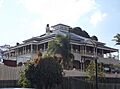
Fairy Knoll residence, 2015
-
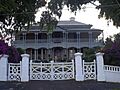
Garowie, 2015


