Edwards Run facts for kids
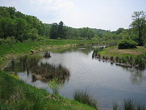
Edwards Run is a small stream, about 7.9 miles (12.7 kilometers) long, located in Hampshire County, West Virginia. It's like a smaller river that flows into a bigger one, the Cacapon River. The Cacapon River then joins the Potomac River, and all that water eventually reaches the Chesapeake Bay. So, Edwards Run is part of a big family of connected waterways!
The stream is named after Joseph Edwards and his family, who owned a large farm that covered much of the stream's path a long time ago. Even George Washington, who later became the first President of the United States, helped map out their land in the 1740s! Many different kinds of water plants, like elodea, grow in Edwards Run.
Where Edwards Run Starts and Flows
Edwards Run begins its journey between two mountains: Cooper Mountain (which is 2,028 feet tall) and Schaffenaker Mountain (1,493 feet tall). This is southwest of a town called Capon Bridge.
The stream flows northeast, passing under U.S. Route 50. It continues to follow along the western side of Schaffenaker Mountain. A cool part of its journey is when it flows through the Edwards Run Wildlife Management Area. Here, a dam creates a 2-acre lake called Edwards Pond. After the pond, the stream goes under Cold Stream Road and finally flows into the Cacapon River, south of Cold Stream.
Fishing Fun at Edwards Pond
Edwards Pond is a great spot for fishing! You can catch different kinds of fish there, including bass, sunfish, bluegill, and channel catfish. If you love trout fishing, you're in luck! Edwards Run and Edwards Pond are stocked with trout from February through March and again in October. This means new trout are added to the water so there are plenty for everyone to try and catch.
 | James Van Der Zee |
 | Alma Thomas |
 | Ellis Wilson |
 | Margaret Taylor-Burroughs |


