
Eglwyseg facts for kids
The Eglwyseg valley is a beautiful area in Denbighshire, Wales. It's found to the northeast of Llangollen. This valley is part of the Llantysilio community. The name Eglwyseg also refers to a small group of homes spread out across the valley.
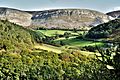
This area was once known as the old township of Eglwysegl. Today, it's famous for its amazing rock formations and historic landscape. It looks much like it did a long time ago.
Contents
Exploring the Eglwyseg Landscape

The most famous part of Eglwyseg is its huge limestone cliff, called the Eglwyseg Rocks (Welsh: Creigiau Eglwyseg). This cliff runs north to south for about 4.5 miles (7.2 kilometers). It's a very impressive sight!
The highest point in the area is at 513 meters (1,683 feet) on Mynydd Eglwyseg (Eglwyseg Mountain). Different parts of the cliff have special names. These include Craig y Forwyn, which means the Maiden's Rock. There's also Craig Arthur (Arthur's Rock), Tair Naid y Gath (the Three Leaps of the Cat), and Craig y Cythraul (Devil's Rock).
The Afon Eglwyseg (Eglwyseg River) flows through the valley. Many smaller streams join it, like the Nant Elli and Nant Craig y Moch.
The very top of the valley is called World's End. It's a popular place for people who enjoy walking, cycling, and sightseeing. The lower part of the valley meets the Vale of Llangollen. The Eglwyseg River then flows into the River Dee near a place called Pentrefelin.
A Look Back in Time: Eglwyseg's History

The entire Eglwyseg valley is a special place. It's been named a Site of Special Scientific Interest. This means it's important for its plants, animals, and geology. It's also a Landscape of Special Historic Interest, showing its rich past.
High up on the moors, you can find several Bronze Age burial mounds. These are ancient graves from thousands of years ago. People have been farming here since the Bronze Age. They used the higher fields for grazing animals in summer. The valleys were used for winter grazing and growing crops. You can still see old farming terraces called lynchets.
In the past, people dug for limestone in the cliffs. There were also several old lead mines. Today, the land is used for different things. Some areas are covered in heather moorland, managed for birds like the Black Grouse. Other parts are used for sheep grazing or have oak woodlands. Some conifer plantations were planted in the second half of the 1900s. Around the year 2000, insects damaged the moorland. It was sprayed to get rid of them, which worked well.
What's in a Name?
The old name for the area was Eglwysegl. Some historians thought it might be named after Eliseg, an old king of Powys. However, it's more likely the name Eglwysegl comes from the Latin word ecclesicula. This means "a small church or chapel."
Long ago, people in this remote valley owned their own farms. They were called yeomanry. A writer named Thomas Pennant described them around 1778. He said they were "independent" and "wealthy." This meant they owned their land and didn't work for big landowners.

An old church, perhaps the chapel mentioned in the name Eglwysegl, was shown on maps from the 1600s. But it was gone by 1808. A new church, St Mary's, opened in 1871. It was built on land given by Sir Watkin Williams-Wynn. This church held its last service in 1985 and is now a home. There was also another chapel built in 1856, but it closed in 1930 and is now in ruins.
Until the early 1900s, there were many places where roads crossed streams without bridges. These were called fords. The road from Esclusham Mountain still crosses the river at World's End this way. You can also find several stone bridges from the 1700s.
Legends and Stories of Eglwyseg

Eglwyseg is part of a famous legend about St. Collen. The story says he killed a giantess named Cares y Bwlch. She even called for help from another giant, Arthur, who lived in the Eglwyseg Rocks! This legend was told in many places, including Corwen.
The old manor house called Plas Uchaf yn Eglwyseg is said to be built where a hunting lodge once stood. This lodge belonged to Owain ap Cadwgan, a prince of Powys. A story says that in 1109, Owain brought Nest ferch Rhys and her children here after taking them from her husband.
There's also a local story that a Prince Llewelyn once hid in a cave in the rocks near Plas Uchaf. There were several Welsh princes named Llewelyn, so we don't know exactly which one. Later, Plas Uchaf was home to John Jones Maesygarnedd. He was an important figure during a big war in England and played a role in the trial of King Charles I.
Eglwyseg Today: Adventure and Nature

The Offa's Dyke Path, a long-distance walking trail, goes through the Eglwyseg area. It's also a very popular spot for rock climbers. There are about 800 climbing routes here, both sport climbing (with fixed ropes) and traditional climbing (where climbers place their own gear).
You can also enjoy the 'Panorama Walk' here. It starts near Blackwood Road, which you can reach from the main A539 road. After a short drive or walk, you'll find a small parking area. From there, a path leads to a stone memorial for a local Welsh poet, I. D. Hooson.
The 'Walk' then joins the Offa's Dyke Path. From here, you get amazing views of the Dee Valley, Castell Dinas Brân (a famous castle), and the mountains beyond. You can also see Trevor Rocks, which is part of the Eglwyseg Escarpment. The Panorama Walk officially ends where it meets Dinbren Road, which leads to Llangollen town center. The Offa's Dyke Path continues on to World’s End.
Eglwyseg is home to some very rare plants. One is the Whitebeam Sorbus anglica. Another is the Welsh Hawkweed (Heiracium cambricum), which has only been found in three places. The rare Limestone Oak Fern (Gymnocarpium robertianum) and Rigid Buckler-Fern (Dryopteris submontana) also grow here.
Images for kids
-
Eglwyseg valley
.jpg)
