El Granada, California facts for kids
Quick facts for kids
El Granada
|
|
|---|---|

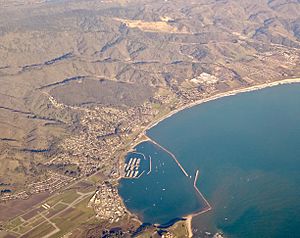
Aerial photograph of El Granada
|
|

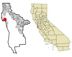
Location in San Mateo County and the state of California
|
|
| Country | United States |
| State | California |
| County | San Mateo |
| Area | |
| • Total | 4.822 sq mi (12.489 km2) |
| • Land | 4.822 sq mi (12.489 km2) |
| • Water | 0 sq mi (0 km2) 0% |
| Elevation | 39 ft (12 m) |
| Population
(2020)
|
|
| • Total | 5,481 |
| • Density | 1,136.67/sq mi (438.87/km2) |
| Time zone | UTC-8 (PST) |
| • Summer (DST) | UTC-7 (PDT) |
| ZIP code |
94018
|
| Area code(s) | 650 |
| FIPS code | 06-21936 |
| GNIS feature ID | 1659720 |
El Granada is a small village located right on the coast in northern San Mateo County, California. It's known as a census-designated place (CDP), which means it's a community that looks like a town but isn't officially a city. In 2020, about 5,481 people lived there. The village got its name from the city of Granada in Spain.
Contents
Where is El Granada Located?
El Granada is found at 37°30′14″N 122°28′24″W / 37.50389°N 122.47333°W. It's on the Pacific coast side of San Mateo County. This area is less crowded than other parts of the county. The village is about 25 miles (40 km) south of San Francisco. It's also about 45 miles (72 km) north of Santa Cruz.
Neighboring Towns
To the north of El Granada, you'll find the towns of Montara and Moss Beach. To the south, the town of Half Moon Bay is nearby.
How Big is El Granada?
According to the United States Census Bureau, El Granada covers a total area of about 4.8 square miles (12.5 square kilometers). All of this area is land.
Who Lives in El Granada?
| Historical population | |||
|---|---|---|---|
| Census | Pop. | %± | |
| 2010 | 5,467 | — | |
| 2020 | 5,481 | 0.3% | |
| U.S. Decennial Census | |||
El Granada is home to a diverse group of people. In 2010, the population was 5,467. By 2020, it had grown slightly to 5,481 residents.
Population Details from 2010
In 2010, most people in El Granada were White (84.3%). About 14.9% of the population identified as Hispanic or Latino. The average age of people living in El Granada was about 44.5 years old. About 21.9% of the population was under 18 years old. Most people (75.9%) owned their homes, while others rented.
History of El Granada
El Granada has a very unique street design. It has a pattern of circles within circles. This special layout was created by a famous architect and city planner named Daniel Burnham.
Daniel Burnham's Vision
Daniel Burnham was a very important designer. He helped plan the 1893 Columbian Exposition in Chicago. He also designed the famous 1902 Flatiron Building in New York City. Burnham designed El Granada for the Ocean Shore Railroad. The railroad wanted El Granada to be a fun seaside resort. Visitors would travel there by train from San Francisco.
Name and Changes
The town was first called "Granada," just like the city in Spain. But in 1909, the Post Office made a mistake and recorded the name as "El Granada." That's how it got its current name! Over time, the railroad faced money problems. Also, more people started using cars to travel. Because of this, the plan for El Granada as a big resort changed. It became the quiet residential community it is today.
Getting Around El Granada
There are a few ways to travel to and from El Granada.
Road Access
The main road to El Granada is State Route 1. This highway is also known as the Cabrillo Highway. You can use it to drive north or south along the coast.
Public Transportation
SamTrans route 117 offers bus service in El Granada. This bus route connects Linda Mar in Pacifica to Half Moon Bay.
See also
 In Spanish: El Granada para niños
 | Roy Wilkins |
 | John Lewis |
 | Linda Carol Brown |


