
Montara, California facts for kids
Quick facts for kids
Montara
|
|
|---|---|

Montara State Beach in Montara
|
|

Location in San Mateo County and the state of California
|
|

Montara, California
Location in the United States
|
|
| Country | United States |
| State | California |
| County | San Mateo |
| Area | |
| • Total | 3.878 sq mi (10.045 km2) |
| • Land | 3.878 sq mi (10.045 km2) |
| • Water | 0 sq mi (0 km2) 0% |
| Elevation | 98 ft (30 m) |
| Population
(2020)
|
|
| • Total | 2,833 |
| • Density | 730.53/sq mi (282.03/km2) |
| Time zone | UTC-8 (PST) |
| • Summer (DST) | UTC-7 (PDT) |
| ZIP code |
94037
|
| Area code(s) | 650 |
| FIPS code | 06-48760 |
| GNIS feature ID | 0277558 |
Montara is a small town located in San Mateo County, California, in the United States. It's a special kind of community called a "census-designated place" (CDP). In 2020, about 2,833 people lived here. Montara is close to other towns like Moss Beach and Princeton-by-the-Sea.
Contents
The Name of Montara: Where Did It Come From?
The name "Montara" has an interesting history. Back in 1867, the area was first called "Montoro" by a group of mapmakers. But by 1869, the United States Coast Survey started using the name "Montara."
People think the name "Montara" might be a misspelled Spanish word. It could come from words like montuoso (meaning "mountainous"), montaraz (meaning "the wild"), or montaña (meaning "mountain").
Another idea is that it comes from the Spanish verb montar, which means "to ride." So, "Montará" means "will ride." This might have referred to people riding horses or wagons through the land. It's possible that people who didn't speak Spanish well might have confused it with "montaña" (mountain).
There's also a theory that "Montara" comes from "Montosa," a Spanish word. "Cañada Montosa" (valley of brush) was a name on an old map from 1838. However, it's not clear if this old map is connected to the town of Montara.
Geography and Natural Environment
Montara is located about 20 miles (32 km) south of San Francisco. It's also about 50 miles (80 km) north of Santa Cruz, California. To the north, you'll find Pacifica. To the south are Moss Beach, El Granada, and Half Moon Bay.
The town covers an area of about 3.9 square miles (10.1 km2), and all of it is land.
Rare Plants and Local Mountains
A very rare plant called Hickman's potentilla grows in the northern part of Montara. You can find it on the hills above Martini Creek.
Nearby is Montara Mountain, which is part of the Santa Cruz Mountains. This mountain rises to about 1,898 feet (578 meters) above the ocean. You can reach the top by a gravel road. Sometimes, a little snow falls on the highest parts of the mountain.
Beaches and Ocean Life
Montara is surrounded by open natural areas, including Rancho Corral de Tierra. A popular spot for fun is Montara State Beach. This beach is almost 1 mile (1.6 km) long. The sand drops steeply into the ocean, which makes it unsafe for swimming. However, it's a favorite place for experienced surfers. During winter storms, waves can reach 10 to 15 feet (3 to 4.5 meters) high.
Off the coast of Montara, you'll find the Montara State Marine Reserve & Pillar Point State Marine Conservation Area. These are like underwater parks. They help protect ocean animals and their homes in the sea.
Climate and Weather in Montara


Montara has very mild weather all year round. Most of the rain falls from November to April, usually more than 27 inches (68 cm) in total. Because it's so close to the Pacific Ocean, Montara often has thick fog and low clouds. These can sometimes cause a light drizzle. Even in the mostly dry summer months, you might see a few light showers.
In January, the coldest month, daytime temperatures are usually between 50° and 60°F (10° and 15°C). Overnight, it cools down to the forties (4° to 10°C). It almost never freezes, especially near the ocean.
September is the warmest month. Daytime temperatures are usually in the upper sixties (15° to 21°C), and lows are around 50°F (10°C). Temperatures rarely go above 90°F (32°C). Even on warm days, the temperature always cools down to around 50°F (13°C) at night.
Montara's Population and People
Montara is home to a diverse group of people. Here's a look at the population based on past surveys.
Population in 2010
In 2010, the population of Montara was 2,909 people. Most of the people (85.6%) were White. About 4.9% were Asian, and 0.7% were Native American. About 11.1% of the population identified as Hispanic or Latino.
There were 1,109 households in Montara. Many of these (31.7%) had children under 18 living there. Most households (60.1%) were married couples. The average household had about 2.62 people. The average family had about 3.02 people.
The age of the people in Montara varied. About 21.2% were under 18 years old. About 39.4% were between 45 and 64 years old. The average age was 46.0 years.
Most homes (81.0%) were owned by the people living in them. About 19.0% of homes were rented.
Population in 2000
In 2000, Montara had 2,950 people living there. The population density was about 751 people per square mile (290 per km2). There were 1,010 households.
About 40.9% of households had children under 18. The average household size was 2.80 people, and the average family size was 3.10 people.
The median income for a household in Montara was $95,326. This means half of the households earned more than this, and half earned less. For families, the median income was $100,881. Only a small number of families (0.5%) and people (2.4%) lived below the poverty line.
History of Montara
.jpg)
Montara has a rich history, starting with a lighthouse and early settlers.
Early Days and the Lighthouse
A lighthouse was built at Point Montara in 1875. It was first a fog signal station. This was important because several ships had crashed in the area in the late 1860s. The lighthouse tower itself was brought from Massachusetts in 1925. It still helps guide ships today. The lighthouse grounds also have an international hostel where travelers can stay.
Farmers were the first people to settle in the Montara area in the late 1800s. A flower farm, which is still in business, started in 1900.
Railroads and Roads
In 1905, Montara became a stop on the new Ocean Shore Railroad. The railroad built a hotel next to the train station. The trains brought weekend visitors to the area. However, the town grew very slowly at first. The railroad stopped running in 1920. But the hotel is still there today, though it has been changed a lot. The old train station building is also still standing.
California's second paved highway, called Pedro Mountain Road, was finished in 1914. This road connected Montara to San Francisco. In 1937, State Route 1 replaced this highway. It followed the old railroad path through a dangerous area called Devil's Slide. A new tunnel opened in 2013 to replace this risky route. The old route often closed because of landslides.
Schools and Growth
The Montara Grammar School opened in 1915. This old two-story building is now used as a community center. Today, children in Montara go to the newer Farallone View Elementary School.
During World War II, the United States Navy had a training center at Point Montara. They trained people to use anti-aircraft guns there.
Montara really started to grow in the 1950s. More people moved there from San Francisco after the war. Even as Montara has grown, it has kept its quiet, rural feel. Many of Montara's streets were dirt or gravel until the early 1990s. Even after some streets were paved, the town still feels rustic.
Transportation in Montara
The main way to get to Montara is by State Route 1. This highway is also known as the Cabrillo Highway. It connects Montara from both the north and the south.
You can also use public transportation. The SamTrans route 117 bus serves Montara. It travels between Linda Mar in Pacifica and Half Moon Bay.
Images for kids
-
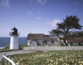
Point Montara Lighthouse, Montara, California. The old Keeper's residence now serves as an International Hostel.
See also
 In Spanish: Montara (California) para niños
