El Infiernito facts for kids

El Infiernito ("The Little Hell"); ancient astronomical site
|
|
| Location | Villa de Leyva, Boyacá |
|---|---|
| Region | Altiplano Cundiboyacense, |
| Coordinates | 5°38′50.63″N 73°33′31.41″W / 5.6473972°N 73.5587250°W |
| Type | Archaeoastronomical site |
| Part of | Pre-Muisca sites |
| History | |
| Material | Sandstone |
| Periods | pre-Herrera Period-Late Muisca |
| Cultures | Herrera-Muisca |
| Satellite of | Muisca Confederation |
| Site notes | |
| Archaeologists | Eliécer Silva Celis, Carl Henrik Langebaek et al. |
| Public access | Yes |
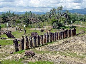
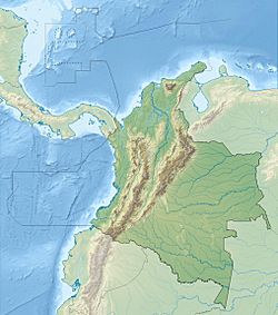
El Infiernito (which means "The Little Hell" in Spanish) is a very old place in Colombia. It's near Villa de Leyva in Boyacá. This site was built by ancient people before Christopher Columbus arrived. It has special stone structures and earth mounds. People believe it was a place for important religious ceremonies and for studying the stars. It was like an astronomical observatory for the Muisca people.
Contents
Why "The Little Hell"?
The Spanish explorers who came to Colombia called this place infiernito. They thought it was a "little hell" because they saw it as a place of non-Christian worship. They didn't understand the local religious practices.
The first time someone officially wrote about this site was in 1847. A Colombian army geographer named Joaquin Acosta described it. He found about 25 stone columns buried in the ground. Later, a famous explorer, Alexander von Humboldt, studied the site. He believed the stones were lined up to predict important events in the sky. These events included solstices (the longest and shortest days) and equinoxes (when day and night are equal).
What the Site Looks Like
The stones at El Infiernito are carved from pink sandstone. Many of them are shaped like columns with a ring carved into them. So far, archaeologists have found 109 large stones, called monoliths.
Fifty-four stones are in the north row, and 55 are in the south row. They are all lined up from east to west. This alignment seems to show how the Muisca calendar worked. The site is divided into two main parts: the north sacred field and the south sacred field.
How Old is El Infiernito?
Scientists have found many pieces of wood charcoal at the site. They use a method called radiocarbon dating to find out how old these pieces are. This helps them understand when people lived here.
They found three main layers of soil, each showing a different time period:
- The oldest layer, from about 2,880 years ago, had burned carved rocks and stone flakes. These were found near a large bonfire and a big stone in the south field.
- A middle layer, from about 2,490 years ago, had lots of animal remains, plant ashes, and special red clay.
- A newer layer, from about 2,180 years ago, mostly showed remains of maize (corn) offerings.
These layers show that people lived in the Altiplano Cundiboyacense area for a very long time.
Protecting the Site
The first official digs at El Infiernito happened in 1981. An anthropologist named Eliécer Silva Celis led these excavations. After his work, the site was declared an archaeological park.
Sadly, many of the ancient burial mounds at the site were damaged by grave robbery. This means people dug them up illegally to steal valuable items. Because of this, many human remains were scattered. Also, a very tall stone column, about 5 meters high, was missing. This column was important because it helped measure the sun's position during the equinoxes.
Later, an expert named Juan Morales studied the stone alignments more closely. He found that the main columns line up with the sunrise during the equinoxes. They point to the top of Morro Negro hill. He also found that the summer solstice sun rises above the sacred Lake Iguaque, which the Muisca believed was their birthplace.
Other Ancient Stone Sites
The Muisca people built other stone monuments too. You can find more of these ancient sites in places like Sutamarchán, Tunja, Ramiriquí, Tibaná, and Paz de Río.
See also
 In Spanish: Parque Arqueológico de Monquirá para niños
- Archaeoastronomy
- Muisca astronomy, calendar
- Lake Iguaque, Villa de Leyva, Carl Henrik Langebaek, Eliécer Silva Celis
 | Emma Amos |
 | Edward Mitchell Bannister |
 | Larry D. Alexander |
 | Ernie Barnes |


