Elba, New York facts for kids
Quick facts for kids
Elba, New York
|
|
|---|---|

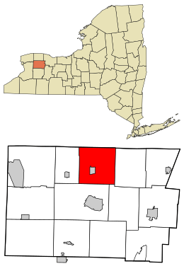
Location in Genesee County and the state of New York
|
|
| Country | United States |
| State | New York |
| County | Genesee |
| Government | |
| • Type | Town council |
| Area | |
| • Total | 35.69 sq mi (92.44 km2) |
| • Land | 35.65 sq mi (92.33 km2) |
| • Water | 0.04 sq mi (0.11 km2) |
| Population
(2010)
|
|
| • Total | 2,370 |
| • Estimate
(2016)
|
2,300 |
| • Density | 64.52/sq mi (24.91/km2) |
| Time zone | UTC-5 (Eastern (EST)) |
| • Summer (DST) | UTC-4 (EDT) |
| FIPS code | 36-037-23756 |
Elba is a town in Genesee County, New York, United States. It is located near the northern border of the county. In 2010, about 2,370 people lived there. The town is north of the city of Batavia. The village of Elba is found near the center of the town.
Contents
History of Elba
The first settlers arrived in the Elba area in 1803. The town of Elba was officially created in 1820. It was formed from a part of the town of Batavia. Later, in 1842, a section of Elba became the new town of Oakfield.
In 1884, the community of Elba became its own separate village. This meant it had its own local government.
Elba was also known for its three mines. These mines were first started in 1788.
Geography of Elba
Elba covers about 35.7 square miles (92.5 square kilometers) of land. There is no significant water area within the town.
The northern border of the town touches Orleans County. Specifically, it borders the town of Barre.
A part of the Alabama Swamp is located in the northwest corner of Elba. The Oak Orchard Creek flows through this swampy area.
Two main roads cross in the village of Elba. These are NYS 98 (running north-south) and NYS 262 (running east-west).
You might find the area around Ridge Road called "Bulgary Ridge" on maps. Older maps from 1897 called it "Vulgary."
Torrey Farms, one of the biggest farms in New York, is located right here in the town of Elba.
People of Elba
| Historical population | |||
|---|---|---|---|
| Census | Pop. | %± | |
| 1820 | 1,333 | — | |
| 1830 | 2,679 | 101.0% | |
| 1840 | 3,161 | 18.0% | |
| 1850 | 1,772 | −43.9% | |
| 1860 | 2,040 | 15.1% | |
| 1870 | 1,905 | −6.6% | |
| 1880 | 1,968 | 3.3% | |
| 1890 | 1,746 | −11.3% | |
| 1900 | 1,526 | −12.6% | |
| 1910 | 1,384 | −9.3% | |
| 1920 | 1,394 | 0.7% | |
| 1930 | 1,695 | 21.6% | |
| 1940 | 1,855 | 9.4% | |
| 1950 | 1,920 | 3.5% | |
| 1960 | 2,260 | 17.7% | |
| 1970 | 2,312 | 2.3% | |
| 1980 | 2,487 | 7.6% | |
| 1990 | 2,407 | −3.2% | |
| 2000 | 2,439 | 1.3% | |
| 2010 | 2,370 | −2.8% | |
| 2016 (est.) | 2,300 | −3.0% | |
| U.S. Decennial Census | |||
In 2010, the population of Elba was 2,370 people. This means there were about 64.5 people living per square mile.
Most of the people in Elba are White. There are also smaller groups of African American, Native American, and Asian residents. About 5.25% of the population is of Hispanic or Latino background.
The average household in Elba had about 2.82 people. The average family had about 3.18 people.
Communities and Locations in Elba
The town of Elba includes several smaller communities and places:
- East Elba – This is a small hamlet located on Norton Road. It is in the southeast part of the town.
- Elba – This is the main village within the town. It is located on Route NY-98.
- Davis Corners – This used to be a community in the southern part of the town.
- Daws (also called "Daws Corners") – This spot is south of Elba village. It is on Route NY-98, right at the southern border of the town.
- Five Corners – This is another hamlet. It is located south of East Elba, also near the town line.
- Langton Corners – This community is north of the village. You can find it on Oak Orchard Road.
See also
 In Spanish: Elba (Nueva York) para niños

