
Embrach facts for kids
Quick facts for kids
Embrach
|
||
|---|---|---|
 |
||
|
||

Embrach
Location in Switzerland

Embrach
Location in Canton of Zürich
|
||
| Country | Switzerland | |
| Canton | Zürich | |
| District | Bülach | |
| Area | ||
| • Total | 12.7 km2 (4.9 sq mi) | |
| Elevation | 428 m (1,404 ft) | |
| Highest elevation
(Tisch on top of Blauen)
|
609 m (1,998 ft) | |
| Lowest elevation
(Töss)
|
360 m (1,180 ft) | |
| Population
(Dec 2020 )
|
||
| • Total | 9,610 | |
| • Density | 757/km2 (1,960/sq mi) | |
| Postal code |
8424
|
|
| Surrounded by | Bülach, Dättlikon, Freienstein-Teufen, Lufingen, Oberembrach, Pfungen, Rorbas, Winkel | |

Embrach is a town in Switzerland. It is located in the canton of Zürich, within the Bülach district. Embrach is a municipality, which means it's like a local government area.
Contents
Embrach's Coat of Arms
Embrach has a special symbol called a coat of arms. It shows two silver keys crossed over each other on a red background.
These keys are a nod to Saint Peter. Long ago, until the mid-1500s, the town used seals with Saint Peter's image. When the Reformation happened, people changed to a more everyday symbol. But they kept the keys to remember their history.
Exploring Embrach's Geography

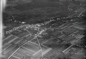
Embrach is in a valley called "Embrachertal." This valley is shaped like a wide "U" and is about 6 kilometers (3.7 miles) northeast of Zurich's international airport. The valley floor is a flat area, about 5 kilometers (3.1 miles) long and up to 1.5 kilometers (0.9 miles) wide.
Hills surround the valley. The Blauen hill is to the east, and Dättenberg is to the west. A stream called Wildbach flows north through the valley. It eventually joins the Töss river. This landscape was shaped by a huge glacier during the Ice Age.
Embrach covers about 12.72 square kilometers (4.9 square miles). Almost half of this area (45%) is covered by forests. About 35% is used for farming, and 18% is for buildings and roads. The area with buildings is growing steadily.
The village itself stretches about 3 kilometers (1.9 miles) along its main street. It's known as a "Street Village" because of this long shape. The best places to live are on the sunny slopes of Sonnenberg and Guldenberg to the east. People have grown grapes on these slopes for hundreds of years.
The highest point in Embrach is the "Tisch" (table) on top of the Blauen hill, at 609 meters (1,998 feet) above sea level. The lowest point is in the Töss river, at 360 meters (1,181 feet) above sea level. The center of the village, where the Reformed Church is, sits at 428 meters (1,404 feet) high.
Embrach's Population
Embrach has a population (as of 31 December 2020) of 9,610.
| Historical population | ||||||||||||||||||||||||||||||||||||||
|---|---|---|---|---|---|---|---|---|---|---|---|---|---|---|---|---|---|---|---|---|---|---|---|---|---|---|---|---|---|---|---|---|---|---|---|---|---|---|
|
|
|
||||||||||||||||||||||||||||||||||||
In 2007, about 21% of the people living in Embrach were from other countries. In 2000, about 43% of the people were Protestant, and 31% were Catholic. About 14% said they had no religion.
Embrach's Economy

Embrach has over 3,000 households. The town is quite busy, with about 675 people living in each square kilometer. More than half of the people in Embrach (56%) own a car.
The town offers about 3,500 jobs. Many of these jobs (75%) are in the service sector, like shops or offices. Nearly 25% are in manufacturing and industry, making things. A small number of jobs are in farming.
Many jobs are in trade and maintenance (over 25%), and transport (20%), especially at companies in Embraport. Health and social services, like the Psychiatric Center Hard, make up 18% of jobs. Manufacturing is 17%, and real estate, computer science, and education make up 11%.
A family home in a good spot might cost around 1 million Swiss Francs (CHF). Rent for a four-room apartment can be between 1,400 and 2,100 CHF per month. Embrach also has 58 hotel beds for visitors and 12 restaurants. There are four grocery stores in the village for daily needs.
Education in Embrach

The local school board, called the Schulpflege, makes sure that primary school education runs smoothly. They handle the big decisions for the schools. A separate school board manages the day-to-day tasks, like teaching, staff, and administration.
Embrach's school system includes kindergarten, primary school, and secondary school. About 1,600 students attend classes in different locations. The main school buildings are Schoolhouse Dorf, Hungerbühl, and Ebnet. There are also sports fields and gym halls.
For higher education, students can go to Gymnasiums in nearby Bülach, Winterthur, or Zürich. Universities in Winterthur and Zürich also offer advanced studies.
Embrach's Industrial Past

Textile Industry The first big factory in Embrach was the Zinggeler silk factory, which opened in 1871. This building was taken down in 1988 to make a parking lot. What's left is a nature reserve called "Chlostergumpen," which was once the factory's water supply.
Many spinners and weavers used to work in the valley. Today, the Spirella Company is one of the last companies from this tradition. They still make shower curtains for people all over the world. Most other textile companies closed after 1987.
Pottery Industry The "Ziegelhütte" brick factory was a pioneer in pottery. Its history goes back to the Middle Ages. Other companies like Ofenganz and Töferei Zangger Neri continued this tradition until about 1980. Now, they mostly sell pottery goods or have closed. Only the Landert pottery still makes items in Embrach.
Machine Industry Blacksmiths have been in Embrach since the Middle Ages, making tools for farmers. Over time, other companies started up. These included Meili weapons (until 1914), Bölsterli Setma Electric Motors, and Zwinggi, which made washing machines and milling machinery. Other companies made medical instruments and precision parts.
Communications The telegraph arrived in Embrach in 1872. Twenty-three years later, the first telephone was installed. Since 1992, three mobile phone networks have served the valley. People can also get broadband internet and digital television.
Natural Resources
Embrach has been a source of silica sand, which is used to make glass in Bülach. There was even a mine on a hillside east of the village. The ground in Embrach also has a lot of gravel.
Since the 800s, people have used hydropower from the Illinger mill. In the mid-1800s, many industries used water power from old reservoirs in the valley. Today, the Haumühle still uses a waterwheel. Since 2004, a small power plant on the Töss River has produced electricity for about 1,000 people.
Traffic and Transport in Embrach
Old Trade Routes
In the Middle Ages, a trade route passed through Embrach. It connected places like Stein am Rhein to Kloten, and then went on to Geneva. Goods like wine, iron, salt, and spices were carried along this route, which was mostly a dirt path for horses.
Modern Roads
In 1838, a bridge was built over the Töss river. This made it easier to travel, no matter the weather. It helped create new roads, like the one connecting Pfungen, Embrach, and Rorbas. A stone bridge over the river at Rorbas was built in 1840.
Building roads through difficult areas, like the "Kohlenschwärze" forest, was a challenge. But by 1850, the road there was finished. Roads connecting Embrach to Lufingen and Kloten (south) and Rorbas to Glattfelden (north) were also built. By 1858, a better road to Bülach was completed. These new roads were well-built and wide, lasting until the 1970s. Since 1905, Embrach's streets have had electric lights.
From Stagecoach to Modern Transport

From 1862, a mail and stagecoach service ran between Rorbas, Embrach, and Kloten for 20 years.
Then came the railway! Construction of the "Winterthur - Embrach - Bülach - Koblenz" railway line started in 1874. Many workers, mostly from Italy, helped build it. A railway bridge over the Wildbach was built in 1875. The Dättenberg tunnel was completed in 1875, and the whole line opened in 1876. This railway helped Embrach grow, especially towards the north. The SBB took over this line in 1902.
The first bus line started in 1932. Today, the ZVV line 520 connects Teufen, Freienstein, Rorbas, Embrach, and Zurich Airport. Since 1990, the Zürcher Verkehrsverbund (ZVV) has improved train and bus connections. Embrach now has half-hourly connections to Bülach (5 minutes), Kloten (10 minutes), Winterthur (20 minutes), and Zürich (35 minutes).
Future of Transport

A big challenge for Embrach is the amount of traffic. In 2007, up to 17,000 vehicles drove through the main road every workday.
Plans for bypass roads around Embrach have existed since the 1950s. A small part of a northern bypass was built in 1976, but a full bypass through the Dättenberg has not happened yet. There are plans for a highway connecting Bülach and Winterthur, which would be part of a larger bypass around Zurich. Other ideas include an east bypass or a tunnel. However, there isn't enough money for these big projects yet.
Embrach-Rorbas Railway Station
The Embrach-Rorbas railway station is served by the Zurich S-Bahn line S41. This train line connects Winterthur and Waldshut.
Embrach's History
Early Beginnings
The first signs of people living in the Embrach valley date back to the Bronze Age, around 800 BC. We know this from graves found in Oberembrach. There are also signs of Roman settlements in the wider area, though fewer directly in Embrach valley.
The name Embrach likely comes from an old language mix of Gallo-Roman. It might mean "fields of rain" or "fields of brickmakers." The second meaning fits well with the town's later history!
The Middle Ages

People from the Alamanni tribe were first mentioned around 750 AD. In 820, a record talks about the hamlet and mill of Illingen. This mill shows that farming was important in the Embrach Valley even then.
The first monastery in Embrach was built in the 800s. We know this from discoveries made during excavations in 1992. Embrach was first mentioned in writing in 1044. During the War of Sempach (1386) and the Old Zurich War (1444), soldiers from the Eidgenossen (Swiss Confederation) attacked and damaged the church and monastery.
After these wars, Embrach came under the control of the state of Zurich. A Latin school was documented at the Abbey in 1454. Around the year 1500, the population grew a lot. This led to high prices and poverty. To help, the town encouraged wine and wood production. Growing grapes employed more people than farming.
From Reformation to Community

Heinrich Brennwald was the last head of the Embrach Monastery. In 1524, the monastery was closed down because of the Zurich Reformation. Embrach then became a reformed (Protestant) town.
In 1547, the town's current coat of arms, with the two crossed keys, appeared for the first time. With the Reformation, more effort was put into educating children. Classes were held in the parish office and later in another building.
A very cold winter in 1571 caused prices for food and land to skyrocket. Zurich allowed the town to sell off parts of its property. About one-fifth of the people became very poor.
In 1715, a big hail storm destroyed the village. People from the region and Zurich donated a lot of money to help repair the damage, which took up to three years. In 1739, strong autumn storms flattened the forest, causing huge financial losses.
In 1778, an earthquake shook Embrach, and the church, built in 1446, collapsed. It had never been very stable. A new church was finished in 1780, just before major political changes. This church, designed by David Vogel, is still used today.
The Age of Enlightenment

In 1799, many Austrian and French soldiers were in the Embrach valley. The damage caused was estimated to be very high. In 1803, Napoleon helped create the Canton of Zurich. In 1809, Oberembrach became its own independent town. Because of this, Embrach was called Unterembrach (Lower Embrach) until 1931.
In 1831, a new, more liberal constitution was adopted for the canton. This led to a period of great growth and development. Modern roads and railways were built, communication services started, and new school houses and health services were established. The main administrative office for the area moved to Bülach in 1831.
In 1856, a robbery led to a murder in Embrach. The two people responsible were caught and executed in Zurich just 14 days later. Thousands of people watched this, which was one of the last civilian executions in the Canton of Zurich.
Embrach Today


For a long time, industries in the Embrach valley used local water power to create electricity. You can still see many small ponds that were used for this. In 1904, a power plant was built, and a year later, the streets got electric lights.
In 1934, a swimming pool called the Chlostergumpen was built. Big land improvements were made between 1963 and 1965.
Because of its good location near Winterthur, Bülach, Zurich, and especially Zurich Airport, Embrach grew very quickly between 1960 and 1965. Swissair built a whole neighborhood for its employees. New family homes were built on the Sonnenberg, and apartment buildings went up in "Im Feld."
Since 1965, there has been a shooting range for hunters near the Töss River. In 1972, an indoor and outdoor swimming pool, "Badi Talegg," was built. It was updated and expanded in 2004-2005.
A big change happened in 1972 when a large construction project started on the north side of Embrach. This was the duty-free Embraport site, which opened in 1973.
After many years of planning, the third Psychiatric Clinic of the Canton of Zurich opened in Embrach in 1974. A center for asylum seekers has also been in the area since 1989. The Psychiatric Center Hard (PZH) joined with another psychiatric group in 2010.
Since 1982, the towns in the Embrach Valley have operated a retirement home for up to 100 elderly people. In 1999, a huge storm called Hurricane Lothar damaged large areas of the local forests.
In 2004, the hydroelectric power station on the Töss River was modernized. It now produces enough electricity for about 1,000 people in the Canton of Zurich each year.
Culture and Leisure in Embrach
Artists from Embrach
.jpg)
Hedwig Neri (1914–1997) was an artist from Embrach. She painted with ceramics and faience, and also worked with glass, textiles, and oil paint. Her home, the old Amtshaus, was a cultural hub that attracted many artists.
Bella Neri (*1942) is Hedwig Neri's daughter. She became an actress, working in theater, film, and television. Bella Neri has performed with famous Swiss actors. She also creates productions for children.

Alain Garnier (1926–2005) was a French artist who lived in Embrach. He was a painter, ceramist, and metal sculptor. He even worked on stage designs for plays. Garnier moved to Switzerland in 1972 and to Embrach in 1980. He had workshops here. You can see his art in Embrach, like the fountain in front of the Post Office and an iron sculpture at the village schoolhouse.
Arthur Woods (*1948) is a Swiss-American artist who lived in Embrach for many years. He created "Space Art" projects. His sculpture, "The Cosmic Dancer," even visited the Russian Mir space station in 1993! Arthur's large oil paintings often show scenes from around Embrach.
David Thayer is a Swiss-American artist who has lived in Embrach since 2007. He has released two albums with his band "Little Tornadoes." He has also made many films, including documentaries.
Places to See

- Töss River Canyon: Near "Bindensteg," the Töss canyon is a protected area. It's a beautiful place to visit.
- Haumühle: This historic sawmill and flour mill is powered by large water wheels. The area around the mill is a nature reserve with rare plants and birds, like the Kingfisher. A creek flows through a small gorge here, creating a waterfall before joining the Töss river.
- Forenirchel Viewpoint: From the top of Forenirchel, you can see the Embrachertal valley and even the Alps. There are walking paths from nearby castles and towns.
Fun Activities
- Badi Talegg: This swimming pool complex has an indoor pool, a whirlpool, an outdoor pool surrounded by trees, and a Finnish sauna. It's a great place to relax and swim.
- Walking on the Blauen: You can enjoy a forest trail on the Blauen hill. It's easy to reach from the "Warpel" parking area.
- Wildbach Creek Walk: Take a walk from Oberembrach to Rorbas, following the creek through the town. There are grilling spots at the Haumühle, with wood ready to use.
- Dättenberg Walk: Hike on the Dättenberg from Augwil to Tössegg. There are several places to grill along the way.
Images for kids
-
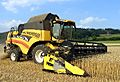
Harvester on Embrach cornfields
-
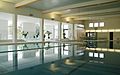
Swimming pool "Badi Talegg"
-
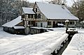
The ancient saw and flour mill "Haumühle"
-
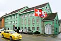
The green town hall
-
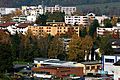
Residential area "Im Feld"
-
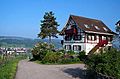
Winery "Guldenberg"


