
Ermatingen facts for kids
Quick facts for kids
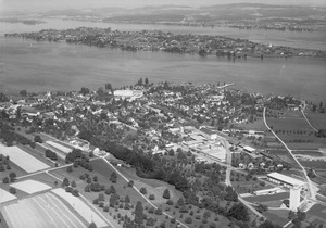
Ermatingen
|
||
|---|---|---|

Ermatingen village
|
||
|
||

Ermatingen
Location in Switzerland

Ermatingen
Location in Canton of Thurgau
|
||
| Country | Switzerland | |
| Canton | Thurgau | |
| District | Kreuzlingen | |
| Area | ||
| • Total | 10.46 km2 (4.04 sq mi) | |
| Elevation | 400 m (1,300 ft) | |
| Population
(Dec 2020 )
|
||
| • Total | 3,640 | |
| • Density | 348.0/km2 (901.3/sq mi) | |
| Postal code |
8272
|
|
| Surrounded by | Constance (Konstanz) (DE-BW), Gottlieben, Raperswilen, Reichenau (DE-BW), Salenstein, Tägerwilen, Wäldi | |

Ermatingen is a lovely town in Switzerland. It's located in the Thurgau canton, which is like a state, and is part of the Kreuzlingen district.
Contents
History of Ermatingen
Ancient Times
People have lived in the Ermatingen area for a very long time! In 1861, scientists found old settlements from the Stone Age along the shoreline. These settlements were studied more closely between 1981 and 1983. They found items from different ancient cultures like the Pfyn culture, Horgen culture, and Corded Ware culture, which existed between 4000 and 2500 BC. That's over 6,000 years ago!
Later, an old graveyard belonging to the Alamanni people was found outside the early medieval village. The Alamanni were a group of Germanic tribes.
From Village to Town
The village of Ermatingen was first mentioned in writing in the year 724. Back then, it was called Erfmotingas. It belonged to the Reichenau monastery, which was a type of religious community. The abbot, who was the head of the monastery, acted as the landlord and judge for the village. He also chose the priest.
The monastery had a special officer called a Meier who managed the local court. Sometimes, the right to be the Meier was given as security for a loan. For example, in 1446, it was given to the Lords of Klingenberg.
In 1499, during the Swabian War, Ermatingen was unfortunately destroyed. But the town rebuilt itself! By the 16th century, Ermatingen was growing into a proper town. It had its own council, a court, and special rights. In 1660, Ermatingen was even given the right to hold a market, which was a big deal for trade and business.
After 1540, the local court rights were held by the Bishop of Constance until 1798.
Religious Changes
The local church parish in Ermatingen used to cover a large area, including Mannenbach and Triboltingen. The church itself was built in 1359. In 1528, Ermatingen decided to join the Protestant Reformation. This meant that even though the town was mostly Protestant, the Catholic Abbey (and later the Catholic Bishop of Constance) still had the right to choose the town's priest. This unusual situation lasted until 1804, when Ermatingen finally gained the right to choose its own priest.
The town church became a shared church in 1546. This means it was used by both Catholic and Protestant communities.

Modern Development
In 1756, the community gained more control over its own affairs. By the late 1700s, Ermatingen had rights over local customs and navigation on the lake.
In the 19th century, the main ways people made a living were fishing, growing grains and fruit, and making wine (viticulture). Things changed a lot with better transport! The Seestrasse (Lake Road) was improved in 1823, steamships started running on the lake in 1825, and a railway arrived in 1875. These improvements brought more people and trade to Ermatingen.
After 1870, tourism became a very important industry. People started visiting Ermatingen for holidays. Later, factories for mechanical embroidery and tin cans opened. Today, agriculture is less important. Ermatingen is now known as a training site, with places like the UBS Training Center at Schloss Wolfsberg (opened in 1975) and the Entrepreneurs' Forum Lilienberg (since 1989). Many jobs in Ermatingen are now in the services sector, like tourism and education.
Geography of Ermatingen
Ermatingen is located in the Kreuzlingen district. It sits right on the Untersee part of Lake Constance. This lake is very beautiful, and Ermatingen is directly across from Reichenau Island in Germany. The municipality includes the villages of Ermatingen and Triboltingen.
Land Use
Ermatingen covers an area of about 10.4 square kilometers.
- About 41.4% of the land is used for farming.
- About 42.0% is covered by forests.
- About 13.4% has buildings or roads.
- A small part (0.1%) is rivers or lakes.
- About 3.0% is unproductive land, like rocky areas.
Over the last two decades, the amount of land with buildings has grown, while agricultural land has decreased.

People of Ermatingen (Demographics)
Ermatingen has a population of around 2,700 people. As of 2013, about 28% of the people living here are from other countries. The population has been growing steadily.
Languages and Age Groups
Most people in Ermatingen speak German (about 92%). The next most common languages are Italian and Albanian.
When it comes to age groups:
- Children and teenagers (0–19 years old) make up about 18% of the population.
- Adults (20–64 years old) are the largest group, at about 62%.
- Seniors (over 64 years old) make up about 20%.
Population Over Time
Here's how Ermatingen's population has changed over the years:
| year | population |
|---|---|
| 1850 | 1,708 |
| 1900 | 1,728 |
| 1970 | 2,089 |
| 1980 | 1,992 |
| 1990 | 2,171 |
| 2000 | 2,427 |
Important Heritage Sites
Ermatingen has several important historical sites that are protected as Swiss heritage sites of national significance. These are places that are very important to the country's history and culture.
The important sites include:
- The Gasthaus Adler (an old inn)
- The Kehlhof (a historic building)
- The Church of St Albin
- The ancient shoreline settlement of Westerfeld/Büge (from the Stone Age)

The villages of Ermatingen and Triboltingen, along with the wider Untersee region, are also listed as part of the Inventory of Swiss Heritage Sites. This means they are recognized for their special cultural and historical value.
Economy of Ermatingen
In Ermatingen, people work in many different jobs.
- A small number of people work in the primary sector, which means jobs like farming or fishing.
- More people work in the secondary sector, which includes manufacturing and factories.
- The largest number of people work in the tertiary sector, which involves services. This includes jobs in tourism, education, shops, and offices.
Many people who live in Ermatingen also travel to other towns for work. About 51% of workers use a private car to get to work, while about 8.5% use public transport.
Religion in Ermatingen
According to a 2000 survey, about 54% of the people in Ermatingen belong to the Swiss Reformed Church (Protestant), and about 30% are Roman Catholic. There are also smaller numbers of people who belong to other Christian churches or are Islamic. Some people do not belong to any church.
Transport in Ermatingen
Ermatingen is located on the Lake Line, which is a railway line connecting Schaffhausen and Rorschach. The town has two train stations: Ermatingen railway station and Triboltingen railway station. This makes it easy for people to travel to and from Ermatingen by train.
Education in Ermatingen
Ermatingen has its own primary and secondary schools. Most adults (between 25 and 64 years old) in Ermatingen have completed either upper secondary education (like high school) or even higher education, such as university.
School System
In the 2008/2009 school year, there were 197 students in the primary school district.
- There were 54 children in kindergarten.
- There were 63 children in the lower primary level (ages 5-6).
- There were 80 children in the upper primary level.
At the secondary school level, students are grouped based on their performance. There were 100 students in the secondary school district. This level usually starts around age 12 and lasts for three years.
Notable People from Ermatingen
Some famous people have connections to Ermatingen:
- Cesar Lüthi: A Swiss businessman known for sports marketing.
- Oskar Naegeli: A Swiss dermatologist and chess master.
- Otto Naegeli: A Swiss hematologist (someone who studies blood).
- Toto Wolff: A well-known team principal and investor in Formula One racing.
See also
 In Spanish: Ermatingen para niños
