
Escaldes-Engordany facts for kids
Quick facts for kids
Escaldes-Engordany
|
|||
|---|---|---|---|

View of Escaldes-Engordany
|
|||
|
|||

Escaldes-Engordany parish, in red, in Andorra
|
|||
| Country | Andorra | ||
| Capital | Escaldes-Engordany | ||
| Urban areas | See list | ||
| Area | |||
| • Total | 30 km2 (10 sq mi) | ||
| Elevation | 1,050 m (3,440 ft) | ||
| Population
(2015)
|
|||
| • Total | 14,367 | ||
| • Density | 480/km2 (1,240/sq mi) | ||
| Time zone | UTC+1 (CET) | ||
| • Summer (DST) | UTC+2 (CEST) | ||
| Postal code |
AD700
|
||
| ISO 3166 code | AD-07 | ||
| Website | Official website: http://www.e-e.ad/ | ||


Escaldes-Engordany is one of the seven parishes (like a region or district) in Andorra. It is located in the southeast part of the country. Escaldes-Engordany is also the name of the main town in this parish.
Contents
History
How Escaldes-Engordany Was Formed
The Escaldes-Engordany parish was created in 1978. It was formed from a part of the Andorra la Vella parish. It started with two main urban areas: Escaldes and Engordany. Over time, these two towns grew together to become the capital of the parish we know today.
Geography
Where Escaldes-Engordany Is Located
The Escaldes-Engordany parish is in the southeast of Andorra. It shares borders with several other parishes:
- To the north, it borders the Encamp parish.
- To the southwest, it borders the Sant Julià de Lòria parish.
- To the west, it borders the Andorra la Vella parish.
- To the northwest, it borders the La Massana parish.
- To the east and south, it borders Spain.
 |
La Massana | Encamp | Encamp | |
| Andorra la Vella | Lleida province, (Spain) | |||
| Sant Julià de Lòria | Lleida province, (Spain) | Lleida province, (Spain) |
Mountains and Rivers
The highest mountain in the parish is Tossa Plana. It is about 2,904 m (9,528 ft) (or 9,528 feet) tall. This mountain is in the southeast of the parish, right on the border with Spain.
The main rivers in Escaldes-Engordany are the Valira del Nord and the Valira d'Orient. These two rivers join together in Escaldes-Engordany to form the Gran Valira river. Another important river here is the Madriu.
The Capital Town
The town of Escaldes-Engordany is the capital of the parish. It is located in the northwest part of the parish. It is very close to the town of Andorra la Vella. Together, these two towns form the largest urban area in Andorra.
Population
How Many People Live Here?
In 2015, the Escaldes-Engordany parish had 14,367 people living in it. This means there were about 478.9 people for every square kilometer.
Evolution of the population in Escaldes-Engordany
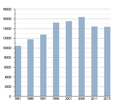
| 1981 | 1986 | 1991 | 1996 | 2001 | 2006 | 2011 | 2015 |
|---|---|---|---|---|---|---|---|
| 10,412 | 11,734 | 12,772 | 15,182 | 15,519 | 16,391 | 14,395 | 14,367 |
Villages
Main Areas in the Parish
The main urban areas in the Escaldes-Engordany parish are:
- Escaldes-Engordany: This is the main town of the parish. It is made up of two parts:
- Les Escaldes (or just Escaldes): This area is about 1,053 m (3,455 ft) (or 3,455 feet) high. The name Les Escaldes comes from the many hot springs found here. These springs have very warm water, between 22 and 66 °C (72 and 151 °F) (or 72 and 151 degrees Fahrenheit). The ancient Romans knew about these hot springs and used them for health reasons. Today, they are used in "Caldea," a popular spa.
- Engordany: This part is about 1,109 m (3,638 ft) (or 3,638 feet) high. It is located on the right side of the Valira d'Orient river, at the base of the Pic de Padern mountain.
- Els Vilars d'Engordany: This area is north of Engordany. Here you can find the Sant Romà dels Vilars chapel, which dates back to the 10th century. It is about 1,861 m (6,106 ft) (or 6,106 feet) high, also at the foot of the Pic de Padern mountain.
- Engolasters: This village is about 2 km (1.2 mi) (or 1.2 miles) east of Andorra la Vella. It is located at an altitude of about 1,504 m (4,934 ft) (or 4,934 feet).
Economy
What People Do for Work
The main way people make money in Escaldes-Engordany is through tourism. The parish is a very popular place for tourists to visit.
Sites of interest
Places to See and Visit
Here are some interesting places you can visit in Escaldes-Engordany:
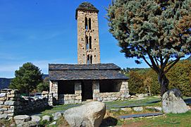
- Sant Romà dels Vilars church: Located in Els Vilars d'Engordany.
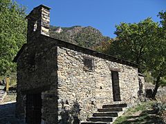
- Sant Miquel d'Engolasters church: Found in Engolasters.
- Pont d'Engordany: A historic bridge that was built in 1785.
- Pont dels Escalls: Another interesting bridge.
- Caldea: A large spa in Les Escaldes, famous for its hot springs.
Gallery
-
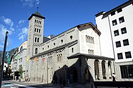
Sant Pere Màrtir church
-
Sant Miquel d'Engolasters church
-
Sant Romà dels Vilars church
-
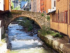
Pont d'Engordany bridge over the Valira river


Images for kids
-

Antoni Martí, 2011
.jpg)
See also
 In Spanish: Las Escaldas-Engordany para niños
