Esto, Florida facts for kids
Quick facts for kids
Esto, Florida
|
|
|---|---|
| Town of Esto | |
| Motto(s):
"The Home of Two-Toed Tom"
|
|

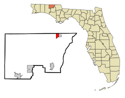
Location in Holmes County and the state of Florida
|
|
| Country | |
| State | |
| County | Holmes |
| Settled | c. 1882-1901 |
| Incorporated | 1963 |
| Named for | Spanish word for "this (is it/the place)" |
| Government | |
| • Type | President-Council |
| Area | |
| • Total | 2.36 sq mi (6.13 km2) |
| • Land | 2.18 sq mi (5.64 km2) |
| • Water | 0.19 sq mi (0.48 km2) |
| Elevation | 233 ft (71 m) |
| Population
(2020)
|
|
| • Total | 341 |
| • Density | 156.49/sq mi (60.41/km2) |
| Time zone | UTC-6 (Central (CST)) |
| • Summer (DST) | UTC-5 (CDT) |
| ZIP code |
32425
|
| Area code(s) | 850 |
| FIPS code | 12-21250 |
| GNIS feature ID | 0282263 |
Esto is a small town in Holmes County, Florida, United States. It's located in the part of Florida known as the Florida Panhandle, which is in the northern area of the state. In 2020, about 341 people lived there. The town's motto is "The Home of Two-Toed Tom," which refers to a famous alligator from local stories!
Contents
Where is Esto, Florida?
Esto is found in the northeastern part of Holmes County. Its exact location is about 30.98 degrees North and 85.65 degrees West.
The town is close to the state of Alabama to its north. To the east, you'll find the town of Noma, Florida. A main road, Florida State Road 79, goes through Esto. This road leads south about 13 miles (21 km) to Bonifay, which is the main city for Holmes County. If you go north on the same road (which becomes Alabama State Route 167 in Alabama), you'll reach Hartford, Alabama, about 9 miles (14 km) away.
Another road, Florida State Road 2, runs along Esto's southern edge. It goes east about 8 miles (13 km) to Graceville. Going west on this road for about 20 miles (32 km) takes you to State Road 81. The closest big city, Dothan, Alabama, is about 25 miles (40 km) northeast of Esto.
The United States Census Bureau says that Esto covers a total area of about 2.36 square miles (6.1 square kilometers). Most of this area, about 2.18 square miles (5.6 square kilometers), is land. The rest, about 0.19 square miles (0.5 square kilometers), is water.
What is Esto's Climate Like?
Esto has a climate known as a humid subtropical climate. This means the area has hot and humid summers. The winters are usually mild, not too cold.
Who Lives in Esto?
| Historical population | |||
|---|---|---|---|
| Census | Pop. | %± | |
| 1910 | 340 | — | |
| 1920 | 269 | −20.9% | |
| 1930 | 190 | −29.4% | |
| 1940 | 213 | 12.1% | |
| 1950 | 217 | 1.9% | |
| 1960 | 148 | −31.8% | |
| 1970 | 210 | 41.9% | |
| 1980 | 304 | 44.8% | |
| 1990 | 253 | −16.8% | |
| 2000 | 356 | 40.7% | |
| 2010 | 364 | 2.2% | |
| 2020 | 341 | −6.3% | |
| U.S. Decennial Census | |||
The numbers above show how Esto's population has changed over many years, from 1910 to 2020.
Esto's Population in 2010 and 2020
The United States Census helps us understand the people living in Esto. Here's a look at the population in 2010 and 2020:
| Race | People in 2010 | People in 2020 | Percentage in 2010 | Percentage in 2020 |
|---|---|---|---|---|
| White (NH) | 342 | 299 | 93.96% | 87.68% |
| Black or African American (NH) | 4 | 14 | 1.10% | 4.11% |
| Native American or Alaska Native (NH) | 2 | 4 | 0.55% | 1.17% |
| Asian (NH) | 2 | 0 | 0.55% | 0.00% |
| Pacific Islander or Native Hawaiian (NH) | 0 | 0 | 0.00% | 0.00% |
| Some other race (NH) | 0 | 3 | 0.00% | 0.88% |
| Two or more races/Multiracial (NH) | 4 | 6 | 1.10% | 1.76% |
| Hispanic or Latino (any race) | 10 | 15 | 2.75% | 4.40% |
| Total | 364 | 341 |
In 2020, there were 341 people living in Esto. These people made up 122 households, and 94 of those were families. In 2010, there were 364 people, 124 households, and 97 families.
Fun Facts and Culture in Esto
Since 1987, Esto has hosted the Two-Toed Tom Festival every year. This festival celebrates a famous, very large alligator from the early 1900s. This alligator was known for being 18 feet long! It was said to have attacked farm animals like cows, and even people.
People could tell it was this specific alligator because it had a unique footprint. It only had two toes on one of its legs. This happened because of a steel animal trap that didn't quite catch it. That's how it got its name, "Two-Toed Tom". For many years, even up until the 1970s, people claimed to see Tom or his special footprints in and around Esto and Holmes County.
See also
 In Spanish: Esto (Florida) para niños
 | Lonnie Johnson |
 | Granville Woods |
 | Lewis Howard Latimer |
 | James West |


