Euharlee, Georgia facts for kids
Quick facts for kids
Euharlee, Georgia
|
|||
|---|---|---|---|

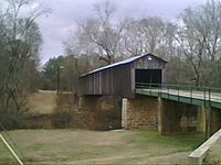
Euharlee Creek Covered Bridge
|
|||
|
|||

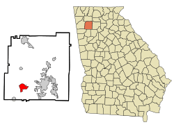
Location in Bartow County and the state of Georgia
|
|||
| Country | United States | ||
| State | Georgia | ||
| County | Bartow | ||
| Incorporated | January 1, 1976 | ||
| Named for | "she laughs as she runs" in Cherokee language. | ||
| Area | |||
| • Total | 5.56 sq mi (14.40 km2) | ||
| • Land | 5.40 sq mi (14.00 km2) | ||
| • Water | 0.16 sq mi (0.40 km2) | ||
| Elevation | 682 ft (208 m) | ||
| Population
(2020)
|
|||
| • Total | 4,268 | ||
| • Density | 789.79/sq mi (304.94/km2) | ||
| Time zone | UTC-5 (Eastern (EST)) | ||
| • Summer (DST) | UTC-4 (EDT) | ||
| ZIP codes |
30120, 30145
|
||
| Area code(s) | 770/678/470/943 | ||
| FIPS code | 13-27988 | ||
| GNIS feature ID | 0313985 | ||
Euharlee is a city in Bartow County, Georgia, United States. In 2020, about 4,268 people lived there. This means the city has been growing!
Euharlee is often called a "bedroom community." This means many people who live in Euharlee travel to nearby Cartersville for work or school. Cartersville is the main city in Bartow County, about 9 miles east. The two cities are connected by Euharlee Road and many neighborhoods. Euharlee is also close to Plant Bowen, a very large power plant.
Contents
The History of Euharlee
Euharlee was first known as Burge's Mill by early settlers in the 1840s. The town officially became a city called Euharlee on September 16, 1870. The name "Euharlee" comes from the Cherokee language. It means "she laughs as she runs," which describes the sound of the Euharlee Creek.
Exploring Euharlee's Geography
Euharlee is located in the southwestern part of Bartow County. You can find it at coordinates 34°8′50″N 84°56′11″W / 34.14722°N 84.93639°W. The Etowah River flows through the eastern side of the city. This river is part of the larger Alabama River system.
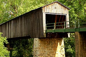
Euharlee Creek joins the Etowah River just south of the city center. The famous Euharlee Covered Bridge crosses this creek. It is one of the oldest covered bridges in all of Georgia!
The city of Euharlee covers about 5.5 square miles (14.1 square kilometers). Most of this area is land, with a small part being water.
People Living in Euharlee
| Historical population | |||
|---|---|---|---|
| Census | Pop. | %± | |
| 1880 | 24 | — | |
| 1890 | 144 | 500.0% | |
| 1980 | 477 | — | |
| 1990 | 850 | 78.2% | |
| 2000 | 3,208 | 277.4% | |
| 2010 | 4,136 | 28.9% | |
| 2020 | 4,268 | 3.2% | |
| U.S. Decennial Census | |||
Euharlee has grown a lot over the years. In 1880, only 24 people lived there. By 2020, the population had grown to 4,268 people. This shows how the city has developed over time.
Who Lives in Euharlee?
In 2020, there were 4,268 people living in Euharlee. These people made up 1,369 households and 1,100 families. Most residents were White (78.96%), followed by Black or African American (8.15%). Other groups included Native American, Asian, and people of mixed races. About 5.76% of the population was Hispanic or Latino.
Fun Places to Visit in Euharlee
Euharlee has several interesting spots to explore:
- Black Pioneer's Cemetery is a special area in downtown Euharlee. It helps remember the graves of some of the first African-American settlers in the region.
- The Euharlee Covered Bridge is a must-see! It crosses Euharlee Creek and is one of Georgia's oldest covered bridges. It was built in 1889 by Washington W. King.
- The Euharlee Welcome Center and History Museum is in historic downtown Euharlee. This museum shows off local items from early Native American times. It also has exhibits about the area's history during the Civil War.
- Kingston Saltpeter Cave is a large cave near Euharlee. It was used to make gunpowder for the Confederacy during the American Civil War. This cave is not open to the public.
Schools in Euharlee
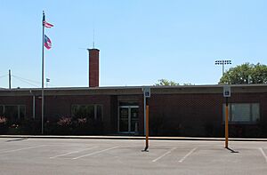
Euharlee is home to two schools that are part of the Bartow County school system:
- Woodland Middle School
- Euharlee Elementary School
These two schools are located right across the street from each other on Euharlee Road.
The Annual Fall Festival
Every October, Euharlee hosts an exciting Fall Festival. The Euharlee Covered Bridge is the main focus of this event. Local schools often perform with their choirs and bands. You can find crafts and food from local sellers. There are also fun rides for kids!
The festival used to be held at Osborne Park. But after Frankie Harris Park was finished in 2005, the festival grew and moved to its new location behind the Emmie Nelson Library.
See also
 In Spanish: Euharlee para niños
 | Sharif Bey |
 | Hale Woodruff |
 | Richmond Barthé |
 | Purvis Young |


