Explorers Monument (Grand Canyon) facts for kids
Quick facts for kids Explorers Monument |
|
|---|---|

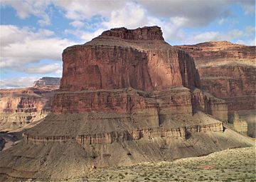
Southwest aspect
|
|
| Highest point | |
| Elevation | 4,572 ft (1,394 m) |
| Prominence | 272 ft (83 m) |
| Isolation | 2.06 mi (3.32 km) |
| Parent peak | Marcos Terrace (5,140 ft) |
| Geography | |
| Location | Grand Canyon National Park Coconino County, Arizona, US |
| Parent range | Colorado Plateau |
| Topo map | USGS Explorers Monument |
| Type of rock | sandstone, limestone, mudstone |
| Climbing | |
| Easiest route | class 4 climbing |
Explorers Monument is a tall rock formation, or summit, in the amazing Grand Canyon. It stands 4,572 feet (about 1,394 meters) high! You can find it in Coconino County, in northern Arizona, USA.
This monument is located about 3.5 miles west of another peak called Mount Huethawali. It sits right inside a bend of the Colorado River. Explorers Monument rises more than 2,400 feet (730 meters) straight up from the river. This makes it a fantastic sight for people who are rafting on the water below!
The top of Explorers Monument is made of rock layers from the Pennsylvanian and Permian periods. These layers are part of something called the Supai Group. Below them, you'll find Redwall Limestone from the Mississippian period. Even deeper, there are rocks from the Cambrian period, known as the Tonto Group. These different rock layers show us how old the Earth is and how it has changed over millions of years! The area around Explorers Monument has a cold semi-arid climate, which means it's usually dry and can get quite cold.
History of the Name
Explorers Monument has an interesting story behind its name. It was first called "Marcos Monument." This name was given by a person named George Wharton James. It was named after a nearby area called Marcos Terrace.
Marcos Terrace itself was named for Marcos de Niza. He was a Franciscan friar and an early explorer. He traveled through parts of what is now the southwestern United States.
Later, the United States Geological Survey decided to change the name. In 1908, they officially called it "Explorers Monument." This new name was chosen to honor several brave explorers of the Grand Canyon. These explorers included Joseph Christmas Ives, George Wheeler, Edward Beale, Almon Thompson, and John Newberry. They all played important roles in mapping and understanding this incredible natural wonder.
Gallery
 | Bessie Coleman |
 | Spann Watson |
 | Jill E. Brown |
 | Sherman W. White |


