Falls Creek, Pennsylvania facts for kids
Quick facts for kids
Falls Creek, Pennsylvania
|
|
|---|---|
|
Borough
|
|

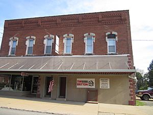
Downtown Falls Creek
|
|

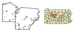
Location of Falls Creek in Jefferson County, Pennsylvania.
|
|
| Country | United States |
| State | Pennsylvania |
| County | Jefferson |
| Incorporated | 1848 |
| Government | |
| • Type | Borough Council |
| Area | |
| • Total | 0.94 sq mi (2.43 km2) |
| • Land | 0.93 sq mi (2.41 km2) |
| • Water | 0.00 sq mi (0.01 km2) |
| Elevation | 1,460 ft (450 m) |
| Population
(2020)
|
|
| • Total | 1,036 |
| • Density | 1,111.59/sq mi (429.22/km2) |
| Time zone | UTC-5 (Eastern (EST)) |
| • Summer (DST) | UTC-4 (EDT) |
| ZIP code |
15840
|
| Area code(s) | 814 |
| FIPS code | 42-25136 |
Falls Creek is a small town, also called a borough, located in Pennsylvania. It's special because it's in two different counties: Jefferson County and Clearfield County. In 2020, about 1,036 people lived there.
Contents
History of Falls Creek
Falls Creek was first planned out in 1891. It officially became a borough in 1900. This happened when it separated from a part of Washington Township in Jefferson County. The town got its name from a nearby stream called Falls Creek.
In 1924, the borough grew by adding land from Clearfield County. This meant Falls Creek was located in both counties for many years. In 2025, the part of Falls Creek that was in Clearfield County officially became part of Jefferson County.
Geography and Location
Falls Creek is located in the eastern part of Jefferson County. Its exact location is 41°8′37″N 78°48′12″W / 41.14361°N 78.80333°W. Most of the town is nestled between two creeks. Falls Creek is to the north, and Sandy Lick Creek is to the south. Falls Creek flows into Sandy Lick Creek. Both of these creeks are part of the Redbank Creek system. This system eventually drains into the Allegheny River to the west.
Major Roads and Travel
Important highways meet just northeast of Falls Creek. These include Interstate 80 and U.S. Route 219. Interstate 80 goes east about 24 miles to Clearfield. It also goes west about 18 miles to Brookville. U.S. Route 219 heads southeast about 3 miles into DuBois. To the north, it goes about 9 miles to Brockway.
Pennsylvania Route 830 runs through the center of Falls Creek. It is known as Main Street and Washington Avenue. Another road, Pennsylvania Route 950, starts from the town center as 3rd Street. It leads about 7 miles southwest to Reynoldsville.
Area and Water Features
According to the United States Census Bureau, Falls Creek covers a total area of about 0.94 square miles (2.43 square kilometers). A very small part of this area, about 0.004 square miles (0.01 square kilometers), is covered by water. This means that about 0.48% of the borough is water.
Population and People
| Historical population | |||
|---|---|---|---|
| Census | Pop. | %± | |
| 1910 | 1,204 | — | |
| 1920 | 1,364 | 13.3% | |
| 1930 | 1,231 | −9.8% | |
| 1940 | 1,344 | 9.2% | |
| 1950 | 1,191 | −11.4% | |
| 1960 | 1,258 | 5.6% | |
| 1970 | 1,255 | −0.2% | |
| 1980 | 1,208 | −3.7% | |
| 1990 | 1,087 | −10.0% | |
| 2000 | 983 | −9.6% | |
| 2010 | 1,037 | 5.5% | |
| 2020 | 1,036 | −0.1% | |
| Sources: | |||
In 2000, there were 983 people living in Falls Creek. These people made up 414 households, with 274 of them being families. The population density was about 1,030 people per square mile. There were 445 homes in the borough.
Most of the people in Falls Creek were White (99.08%). A small number were Native American (0.20%) or Asian (0.10%). About 0.61% of the population identified as being from two or more races. About 0.20% of the population was Hispanic or Latino.
Households and Families
Out of the 414 households, 26.1% had children under 18 living with them. More than half (55.6%) were married couples living together. About 7.2% were households led by a female without a husband present. About 33.8% were not families.
About 28.5% of all households had only one person living there. About 12.6% had someone living alone who was 65 years old or older. On average, there were 2.37 people in each household. The average family size was 2.93 people.
Age Distribution
The population of Falls Creek was spread out across different age groups. About 23.3% of the people were under 18 years old. About 7.4% were between 18 and 24 years old. The largest group, 28.0%, was between 25 and 44 years old. People aged 45 to 64 made up 22.3% of the population. Finally, 19.0% of the people were 65 years old or older. The average age in the borough was 38 years. For every 100 females, there were about 95 males. For every 100 females aged 18 and over, there were about 97.9 males.
Income Levels
In 2000, the average income for a household in Falls Creek was $30,455. For families, the average income was $39,219. Men earned an average of $33,417, while women earned an average of $19,732. The per capita income for everyone in the borough was $16,410. About 7.0% of families and 9.5% of the total population lived below the poverty line. This included 9.7% of those under 18 and 11.5% of those aged 65 or older.
Transportation Options
The DuBois Regional Airport is located in Washington Township, Jefferson County. It is about 6 miles northwest of Falls Creek. This airport provides air travel options for residents and visitors.
See also
 In Spanish: Falls Creek para niños
- Appalachia
- Western Pennsylvania English
 | Shirley Ann Jackson |
 | Garett Morgan |
 | J. Ernest Wilkins Jr. |
 | Elijah McCoy |


