
Falls Village, Connecticut facts for kids
Quick facts for kids
Falls Village, Connecticut
|
|
|---|---|
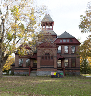
D.M. Hunt Library
|
|

Location in Litchfield County, Connecticut
|
|
| Country | United States |
| State | Connecticut |
| Town | Canaan |
| Area | |
| • Total | 1.59 sq mi (4.13 km2) |
| • Land | 1.59 sq mi (4.13 km2) |
| • Water | 0 sq mi (0.0 km2) |
| Elevation | 640 ft (200 m) |
| Population
(2010)
|
|
| • Total | 538 |
| • Density | 337/sq mi (130.2/km2) |
| Time zone | UTC-5 (EST) |
| • Summer (DST) | UTC-4 (EDT) |
| ZIP Code |
06031
|
| Area code(s) | 860 |
| FIPS code | 09-27390 |
| GNIS feature ID | 2631562 |
Falls Village is a small community in Connecticut, United States. It is a village and a census-designated place. This means it's a specific area recognized by the government for counting people. Falls Village is part of the larger town of Canaan in Litchfield County.
In 2010, about 538 people lived in Falls Village. The entire town of Canaan had 1,234 residents. Falls Village is the main center of the town of Canaan. Because of this, people often call the whole town "Falls Village." This helps avoid confusion with another place called Canaan Village nearby. The name "Falls Village" comes from a beautiful waterfall called Great Falls on the Housatonic River, which runs through the village.
The local post office in Falls Village uses the ZIP code 06031. This ZIP code actually covers the entire town of Canaan.
Contents
Exploring Falls Village's Location
Falls Village is located in the northwestern part of Connecticut. It sits on the western side of the town of Canaan. The Housatonic River forms the western border of the village, separating it from the town of Salisbury.
The village stretches north to Page Road and south to a power line area near Beebe Hill. To the east, Falls Village extends along Connecticut Route 126 up to Johnson Road.
Roads and Travel in Falls Village
U.S. Route 7 is a major road that goes right through Falls Village. If you head north on Route 7, you'll reach Canaan Village in about 6 miles. Traveling south for the same distance will take you to West Cornwall.
Another important road, Connecticut Route 126, starts in Falls Village. It goes east for about 2 miles to connect with Connecticut Route 63. If you go north on Route 126 for about 4 miles, you'll reach U.S. Route 44 in North Canaan.
How Big is Falls Village?
According to the U.S. Census Bureau, the area known as Falls Village is about 4.1 square kilometers (or 1.6 square miles). All of this area is land, with no water.
Discovering the Falls Village Historic District
|
Falls Village District
|
|

St. Patrick's Church
|
|

Location in Connecticut

Location in the United States
|
|
| Location | Canaan, Connecticut |
|---|---|
| Area | 70 acres (0.28 km2) |
| Architect | Lambert & Bunnell; Multiple |
| Architectural style | Greek Revival, Italianate, Queen Anne |
| NRHP reference No. | 79002622 |
| Added to NRHP | June 14, 1979 |
In 1979, a special area in Falls Village was recognized as an historic district. It was added to the National Register of Historic Places. This district covers about 70 acres (or 0.28 square kilometers).
Why is it a Historic District?
The buildings in this historic district were mostly built in the mid-1800s. This happened because the Housatonic Railroad chose Falls Village as a train station stop in the early 1830s. The railroad brought growth and new construction to the area. Newer buildings near the intersection of U.S. Route 7 and Connecticut Route 126 are not part of this historic area.
The historic district shows off different styles of architecture. You can see buildings designed in the Greek Revival, Italianate, and Queen Anne styles. There are 71 buildings in the district, plus a canal. This canal was built to use the power of the water from the Great Falls.
Key Places in the Historic District
Some important buildings in the historic district include the D. M. Hunt Library, which was built in 1891, and St. Patrick's Church.
Images for kids
-
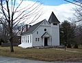
St. Patrick's Church, a contributing property in the historic district.
See also
 In Spanish: Falls Village (Connecticut) para niños
