
Far North (South Australia) facts for kids
The Far North is a huge area that covers about 70 percent of South Australia. Imagine a place so big it stretches across the entire state, from one side to the other! It's about 1,200 kilometers (746 miles) wide and goes about 750 kilometers (466 miles) north from the middle of the state. Many people in South Australia think of anywhere north of Port Augusta as the Far North.
This region is the least populated part of South Australia, meaning not many people live there. It's a place of wide-open spaces and amazing natural beauty.
Quick facts for kids Far NorthSouth Australia |
|||||||||||||||
|---|---|---|---|---|---|---|---|---|---|---|---|---|---|---|---|
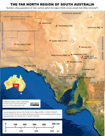
South Australia's Far North region (north of the blue east–west border lines), with main settlements and their populations in 2016
|
|||||||||||||||

Far North
Location in South Australia
|
|||||||||||||||
| Population | 27,727 (2016 census) | ||||||||||||||
| • Density | 0.0397813/km2 (0.103033/sq mi) | ||||||||||||||
| Area | 696,986 | ||||||||||||||
| LGA(s) |
|
||||||||||||||
| State electorate(s) |
|
||||||||||||||
| Federal Division(s) | Grey | ||||||||||||||
|
|||||||||||||||
| Footnotes | Map of adjoining regions | ||||||||||||||
Contents
Exploring the Deserts and Outback

The Far North is mostly rugged outback wilderness and desert. It includes some of the driest places on the entire continent! The climate here is known as a "hot desert" climate.
You'll find several famous deserts in this region:
- In the northeast, there's the Simpson Desert, Tirari Desert, Painted Desert, and Pedirka Desert.
- To the north and northwest, you'll find the huge Great Victoria Desert.
Because it's so dry, the Far North is also often called the "Arid Lands." This name describes the landscape better than just "desert."
How the Far North is Governed
The Far North includes several local government areas. These are like local councils that help manage towns and communities. Some of these include Anangu Pitjantjatjara Yankunytjatjara (APY) lands, the City of Port Augusta, District Council of Coober Pedy, Flinders Ranges Council, and Municipal Council of Roxby Downs.
A large part of the Far North is an "unincorporated area." This means it doesn't have its own local council. Instead, the South Australian Government directly provides services to communities in these areas through the Outback Communities Authority.
Fun Things to Do in the Far North
The Far North is a fantastic place for visitors! It has many national parks and reserves, along with unique attractions spread across the vast landscape.
Here are some cool things you can experience:
- Farmstays: Stay on a real sheep station and see what life is like in the outback.
- Unique Nature: Discover special native plants and animals that you won't find anywhere else.
- Underground Living: Visit Coober Pedy, a town where many people live underground to escape the heat. You can explore museums and even stay in underground hotels!
- Natural Springs: Find amazing natural springs that bring water to this dry land.
- Stunning Landscapes: See huge salt lakes, flat-topped sandstone hills (called tablelands), and brightly colored hills that look like they've been painted.
Important Permits for Travel
Some parts of the Far North require special permission to visit.
- You need a permit to enter Aboriginal-owned land.
- As of 2023, you also need a National Parks and Wildlife Service South Australia Desert Parks Pass to visit the Simpson Desert Conservation Park and Regional Reserve and areas east of Dalhousie Springs in Witjira National Park.
- A tourist pass is also needed to enter the Woomera Prohibited Area.
Major Outback Roads
Several important roads cross this huge region, connecting distant towns:
- The Stuart Highway runs from Port Augusta all the way to Alice Springs.
- The Oodnadatta Track is a famous unsealed road that follows an old railway line.
- The Birdsville Track and the Strzelecki Track are other well-known outback roads that lead towards Queensland.
Travelling in outback South Australia can be very exciting.
The scenery is breathtaking, the wildlife unique and the flora exquisite.
It can also be deadly if you don't plan adequately.
– Information provided by the Outback Communities Authority
