Ferguson, Missouri facts for kids
Quick facts for kids
Ferguson, Missouri
|
|||
|---|---|---|---|
| City of Ferguson | |||

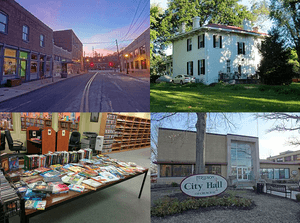
Ferguson's Church Street in 2012, the Wildwood House in 2012, the Ferguson Municipal Library in 2014, and the Ferguson City Hall in 2012
|
|||
|
|||
| Etymology: William B. Ferguson | |||
| Nickname(s):
"Community of Choice"
|
|||
| Motto(s):
"Proud Past. Promising Future!"
|
|||

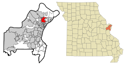
Location within St. Louis County (left) and Missouri (right)
|
|||
| Country | United States | ||
| State | Missouri | ||
| County | St. Louis | ||
| Incorporated | 1894 | ||
| Area | |||
| • Total | 6.18 sq mi (16.00 km2) | ||
| • Land | 6.17 sq mi (15.98 km2) | ||
| • Water | 0.01 sq mi (0.02 km2) | ||
| Elevation | 554 ft (169 m) | ||
| Population
(2020)
|
|||
| • Total | 18,527 | ||
| • Density | 3,003.24/sq mi (1,159.55/km2) | ||
| Demonym(s) | Fergusonian | ||
| Time zone | UTC-6 (Central (CST)) | ||
| • Summer (DST) | UTC-5 (CDT) | ||
| ZIP Code |
63135
|
||
| Area code | 314 | ||
| FIPS code | 29-23986 | ||
| GNIS feature ID | 2394760 | ||
| Website | City of Ferguson | ||
Ferguson is a city in St. Louis County, Missouri, United States. It is part of the larger Greater St. Louis area. According to the 2020 census, about 18,527 people live there. Most of the people living in Ferguson are black.
Contents
History of Ferguson
The city of Ferguson started in 1855. A man named William B. Ferguson gave 10 acres of his land to the Wabash Railroad. In return, the railroad built a new train station there. They also named the area "Ferguson Station" after him.
Ferguson was special because it was the first train station directly connected to St. Louis. The train station is a very important part of the city's past. You can even see it on the city flag, which was designed in 1994.
The first school in Ferguson was built in 1878. Ferguson officially became a city in 1894. Later, a big company called Emerson Electric moved its main office to Ferguson.
In 2014, Ferguson became known around the world due to a sad event. A young man was killed by a police officer, which led to many protests and civil unrest. The United States Department of Justice looked into what happened. This investigation cost the city a lot of money in legal fees.
On June 2, 2020, Ferguson made history again. The city elected its first black mayor, Ella Jones. She was also the first woman to be mayor of Ferguson.
People and Population in Ferguson
| Historical population | |||
|---|---|---|---|
| Census | Pop. | %± | |
| 1880 | 185 | — | |
| 1890 | 750 | 305.4% | |
| 1900 | 1,015 | 35.3% | |
| 1910 | 1,658 | 63.3% | |
| 1920 | 1,874 | 13.0% | |
| 1930 | 3,798 | 102.7% | |
| 1940 | 5,724 | 50.7% | |
| 1950 | 11,573 | 102.2% | |
| 1960 | 22,149 | 91.4% | |
| 1970 | 28,759 | 29.8% | |
| 1980 | 24,740 | −14.0% | |
| 1990 | 22,286 | −9.9% | |
| 2000 | 22,406 | 0.5% | |
| 2010 | 21,203 | −5.4% | |
| 2020 | 18,527 | −12.6% | |
| U.S. Decennial Census 2010 2020 |
|||
The number of people living in Ferguson grew very quickly in the late 1800s. In 1880, only 185 people lived in Ferguson Station. By 1890, the population had grown to 750 people. Just four years later, it reached 1,200.
The population kept growing fast for the first 60 years of the 1900s. It went from 1,015 people in 1900 to 22,149 people in 1960. This was an average growth of 5% each year.
The mix of different ethnic groups in Ferguson has changed over time. In 1970, almost everyone (99%) in Ferguson was white. Only 1% were black. By 1980, the number of white residents went down to 85%. The number of black residents went up to 14%.
In 1990, about 73.8% of Ferguson residents were white. About 25.1% were black. The rest (1.1%) were from other racial groups. By the 2000 U.S. Census, more than half of the population (52.4%) was African American.
2020 Census Information
| Race / Ethnicity (NH = Non-Hispanic) | Pop 2000 | Pop 2010 | Pop 2020 | % 2000 | % 2010 | % 2020 |
|---|---|---|---|---|---|---|
| White alone (NH) | 9,903 | 6,093 | 3,926 | 44.20% | 28.74% | 21.19% |
| Black or African American alone (NH) | 11,718 | 14,252 | 13,302 | 52.30% | 67.22% | 71.80% |
| Native American or Alaska Native alone (NH) | 23 | 78 | 29 | 0.10% | 0.37% | 0.16% |
| Asian alone (NH) | 150 | 102 | 96 | 0.67% | 0.48% | 0.52% |
| Pacific Islander alone (NH) | 4 | 4 | 8 | 0.02% | 0.02% | 0.04% |
| Other race alone (NH) | 29 | 25 | 114 | 0.13% | 0.12% | 0.62% |
| Mixed race or Multiracial (NH) | 351 | 389 | 685 | 1.57% | 1.83% | 3.70% |
| Hispanic or Latino (any race) | 228 | 260 | 367 | 1.02% | 1.23% | 1.98% |
| Total | 22,406 | 21,203 | 18,527 | 100.00% | 100.00% | 100.00% |
The 2020 United States census counted 18,527 people in Ferguson. There were 8,844 households and 5,272 families. The population density was about 3,003 people per square mile.
The racial makeup of the city in 2020 was mostly black (72.15%) and white (21.4%). Other groups made up smaller percentages. About 1.5% of the population was Hispanic or Latino.
About 25.7% of households had children under 18. About 23.9% were married couples. Many households (50.2%) had a female head with no husband present. The average household had 2.3 people.
The median age in Ferguson was 34.3 years. About 29.4% of the people were under 18. About 14.0% were 65 or older.
2010 Census Information
As of the 2010 U.S. Census, there were 21,203 people living in Ferguson. There were 8,192 households and 5,500 families. The city's population density was about 3,425 people per square mile.
The racial makeup in 2010 was about 67.4% black and 29.3% white. Other groups made up smaller parts of the population. About 1.2% of the population was Hispanic or Latino.
About 39.1% of households had children under 18. About 29.6% were married couples. Many households (31.5%) had a female head with no husband present. The average household had 2.56 people.
The median age in the city was 33.1 years. About 28.7% of residents were under 18. About 10.3% were 65 or older.
Geography of Ferguson
Ferguson covers a total area of about 6.20 square miles. Most of this area (6.19 square miles) is land. A very small part (0.01 square miles) is water.
Climate in Ferguson
Ferguson has a climate that is a mix of humid subtropical and humid continental. This means winters are cold, and summers are hot and humid. The highest temperature ever recorded was 115°F. The lowest temperature ever recorded was -19°F.
| Climate data for Ferguson, MO | |||||||||||||
|---|---|---|---|---|---|---|---|---|---|---|---|---|---|
| Month | Jan | Feb | Mar | Apr | May | Jun | Jul | Aug | Sep | Oct | Nov | Dec | Year |
| Record high °F (°C) | 77 (25) |
85 (29) |
92 (33) |
93 (34) |
98 (37) |
105 (41) |
115 (46) |
110 (43) |
104 (40) |
94 (34) |
86 (30) |
79 (26) |
115 (46) |
| Mean daily maximum °F (°C) | 38 (3) |
44 (7) |
55 (13) |
67 (19) |
76 (24) |
85 (29) |
90 (32) |
88 (31) |
80 (27) |
68 (20) |
54 (12) |
42 (6) |
66 (19) |
| Mean daily minimum °F (°C) | 21 (−6) |
27 (−3) |
36 (2) |
47 (8) |
57 (14) |
66 (19) |
71 (22) |
69 (21) |
60 (16) |
48 (9) |
37 (3) |
26 (−3) |
47 (8) |
| Record low °F (°C) | −19 (−28) |
−18 (−28) |
−5 (−21) |
20 (−7) |
31 (−1) |
43 (6) |
51 (11) |
47 (8) |
32 (0) |
21 (−6) |
1 (−17) |
−16 (−27) |
−19 (−28) |
| Average precipitation inches (mm) | 2.14 (54) |
2.28 (58) |
3.60 (91) |
3.69 (94) |
4.11 (104) |
3.76 (96) |
3.00 (76) |
2.98 (76) |
2.96 (75) |
2.76 (70) |
3.71 (94) |
2.86 (73) |
37.85 (961) |
| Average snowfall inches (cm) | 7.4 (19) |
4.8 (12) |
3.3 (8.4) |
0.6 (1.5) |
0 (0) |
0 (0) |
0 (0) |
0 (0) |
0 (0) |
0 (0) |
1.5 (3.8) |
4.9 (12) |
22.9 (58) |
Economy in Ferguson
The main office of Emerson Electric, a large company, is located in Ferguson.
Education in Ferguson
St. Louis Community College-Florissant Valley is in Ferguson. About 8,000 students attend this college.
Most of Ferguson is part of the Ferguson-Florissant School District (FFSD). Here are some of the schools in Ferguson:
- Primary Schools (Grades K-2): Central, Bermuda, Holman, and Walnut Grove.
- Intermediate Schools (Grades 3-5): Lee-Hamilton, Griffith, and Berkeley.
- Secondary Schools: Johnson-Wabash 6th Grade Center, Ferguson Middle School, and McCluer High School.
Some parts of Ferguson are in the Riverview Gardens School District or the Hazelwood School District.
The following FFSD public schools are located within Ferguson:
- STEAM Academy at McCluer South-Berkeley (a special magnet school for grades 9-12)
- Ferguson Middle School (grades 7-8)
- Johnson-Wabash 6th Grade Center
- Griffith Elementary School (grades 3-5)
- Lee-Hamilton Elementary School (grades 3-5)
- Central Elementary School (grades K-2)
Vogt Elementary School closed in 2019.
There are also private schools in Ferguson:
- Blessed Teresa of Calcutta School
- Our Lady of Guadalupe School
- Zion Lutheran School
Ferguson is also home to the Challenger Learning Center – St. Louis. This center offers fun space education programs.
The Ferguson Municipal Public Library is one of many independent libraries in St. Louis County. It is part of the Municipal Library Consortium of St. Louis County.
Notable People from Ferguson
Many interesting people have lived in Ferguson. This list includes people born there, past residents, and current residents.
- General Ralph Eberhart: A high-ranking officer in the U.S. Air Force. He was in charge of the North American Aerospace Defense Command during the September 11 attacks.
- Michael McDonald: A singer who has won Grammy Awards.
- Henry Miller: Also known as Sentoryu, he is a mixed martial artist and used to be a sumo wrestler.
- Delrish Moss: A police veteran from Miami. He became Ferguson's first permanent African-American Police Chief in 2016.
- Susan Notorangelo: A cyclist known for long-distance rides.
- Enos Slaughter: A famous baseball player for the St. Louis Cardinals. He is in the Hall of Fame.
- Harry Tuthill: A cartoonist who created the comic strip The Bungle Family.
- Tyron Woodley: An American mixed martial artist. He used to be the UFC welterweight champion.
See also
 In Spanish: Ferguson (Misuri) para niños
 | William Lucy |
 | Charles Hayes |
 | Cleveland Robinson |


