Ferndale, Western Australia facts for kids
Quick facts for kids FerndalePerth, Western Australia |
|||||||||||||||
|---|---|---|---|---|---|---|---|---|---|---|---|---|---|---|---|

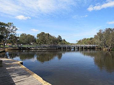
Kent Street Weir, Canning River Regional Park, viewed from the Wilson side of Canning River and with Ferndale on the right of the image.
|
|||||||||||||||
| Established | 1970s | ||||||||||||||
| Postcode(s) | 6148 | ||||||||||||||
| Area | 3.6 km2 (1.4 sq mi) | ||||||||||||||
| Location | 15 km (9 mi) from Perth | ||||||||||||||
| LGA(s) | City of Canning | ||||||||||||||
| State electorate(s) | Cannington | ||||||||||||||
| Federal Division(s) | Swan | ||||||||||||||
|
|||||||||||||||
Ferndale is a cool suburb located in the southeast part of Perth, Western Australia. It's part of the City of Canning area. This suburb is about 15 kilometers (9 miles) away from Perth's city center.
Contents
History of Ferndale
The name Ferndale was chosen by developers. They didn't go with the City of Canning's first idea, which was Shearnstead. In 1965, the name Ferndale was officially approved.
Most of the suburb used to be covered in low scrub forest. It started to be developed and built up in the late 1960s and 1970s.
Geography of Ferndale
Ferndale has some natural borders. To the southeast, it's bordered by Metcalfe Road. The Canning River forms its border to the north and northwest. Bannister Creek is to the southwest.
The main street in Ferndale is Ferndale Crescent. It looks like an upside-down U-shape. The eastern part of this street helps divide Ferndale into southwest and northeast sections.
Things to Do in Ferndale
Ferndale has some great places for fun and activities!
Parks and Recreation
- Ferndale Reserve is a big sports ground. It's a popular spot for playing games and being active.
- The Canning River Regional Park is in the northern part of Ferndale. It's a fantastic place for riding bikes and going for walks along the Canning River.
Schools in Ferndale
For many years, Ferndale had two primary schools: Ferndale Primary and Kinlock Primary.
- Kinlock Primary closed in 2007. Students from Kinlock and Lynwood Primary (a nearby school) moved to Ferndale Primary in 2008.
- In 2009, Ferndale Primary also closed. A new school, Bannister Creek Primary, opened on the old Lynwood Primary site. This new school is named after Bannister Creek, which flows through Ferndale into the Canning River.
- All these primary schools send their students to Lynwood Senior High School, which is the main high school for the area.
Sports Clubs
Along Metcalfe Road, you'll find grounds for cricket and football.
- The cricket grounds are shared with a club nicknamed Faries.
- The football grounds are shared with a club nicknamed Panthers.
Getting Around Ferndale
Ferndale is connected to other areas by its main roads and public transport.
Main Roads
Metcalfe Road is a key road in Ferndale. It links to two other important routes:
- Nicholson Road: This road connects Ferndale to Cannington and a big shopping center called Westfield Carousel.
- High Road: This road links Ferndale to Riverton and the Bull Creek railway station.
Bus Services
Ferndale is served by the Transperth bus service. Bus 508 connects the area to Bull Creek and Cannington. These buses are operated by Swan Transit.
Here are some of the bus routes that serve Ferndale:
- Bus 206: Travels from Cannington Station to Murdoch University. It uses Nicholson Road.
- Bus 208: Goes from Cannington Station to Murdoch Station. It also uses Nicholson Road.
- Bus 507: Connects Cannington Station to Bull Creek Station. It uses Nicholson Road and Metcalfe Road.
- Bus 508: Runs from Cannington Station to Bull Creek Station. This route uses Nicholson Road, Metcalfe Road, Grace Street, Willcock Street, Ferndale Crescent, and High Road.
 | Selma Burke |
 | Pauline Powell Burns |
 | Frederick J. Brown |
 | Robert Blackburn |

