
Fifes Peaks facts for kids
Quick facts for kids Fifes Peaks |
|
|---|---|

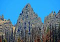
Fifes Peaks - Central Peak seen from Mather Memorial Highway
|
|
| Highest point | |
| Elevation | 6,880 ft (2,100 m) |
| Prominence | 440 ft (130 m) |
| Geography | |

Fifes Peaks
Location in Washington (state)

Fifes Peaks
Location in the United States
|
|
| Location | Yakima County, Washington, U.S. |
| Parent range | Cascades |
| Topo map | USGS Goose Prairie |
| Type of rock | Andesite lava |
| Climbing | |
| Easiest route | Scrambling class 2 |
Fifes Peaks is a cool group of mountains and pointy rocks in Yakima County, Washington state. These peaks are what's left of an ancient volcano that blew up about 25 million years ago! It's been extinct for a very long time.
Fifes Peaks is part of the Cascade Mountains. It sits on the eastern side of the mountain range, inside a special protected area called the Norse Peak Wilderness.
Contents
What are the main peaks at Fifes Peaks?
Fifes Peaks is made up of several important summits. The tallest one is the West Peak.
Here are some of the main peaks:
- Fifes Peaks West Peak - 6,880 feet tall
- Fifes Peaks Central Peak - 6,793 feet tall
- Fifes Peaks East Peak - 6,375 feet tall
- Mainmast - over 6,400 feet tall
- Cannonhole Pinnacle - over 6,600 feet tall
- Teddy Bear Pinnacle - 6,260 feet tall
Who are the Fifes Peaks named after?
The Fifes Peaks got their name from a person named Thomas X. Fife. He lived from 1853 to 1922. Thomas Fife was a miner who looked for gold, especially in riverbeds.
Thomas, along with his brothers and father, John, mined in the area. This was close to a place called Chinook Pass. Thomas Fife also owned land near Goose Prairie, which is close to Bumping Lake.
Camp Fife, a Boy Scout camp located at Goose Prairie, is also named after Thomas Fife. He actually gave the land for the camp to the Boy Scouts in his will.
What's the weather like at Fifes Peaks?
Most of the weather that affects Fifes Peaks comes from the Pacific Ocean. These weather systems, called weather fronts, travel east towards the Cascade Mountains.
When these fronts hit the tall Cascade Mountains, the air is forced to rise. This process is called Orographic lift. As the air goes higher, it cools down and drops its moisture. This moisture falls as rain or snow on the mountains.
Because of this, the western side of the Cascades gets a lot of rain and snow. This is especially true during the winter months. During winter, the weather is usually cloudy. However, in the summer, high-pressure systems over the Pacific Ocean often bring clear skies.
The water from rain and melting snow at Fifes Peaks flows into smaller streams. These streams then join the American River and the Naches River.
Gallery
-
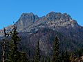
Central and East
-
Mainmast
-
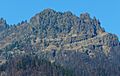
East Peak
-
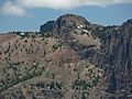
West Peak
-
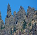
pinnacle


- Fifes Peaks weather forecast
