
Fogo Island (Newfoundland and Labrador) facts for kids
Fogo Island is the largest island off the coast of Newfoundland and Labrador, Canada. It's located northeast of Newfoundland, near the Change Islands. The island is about 25 kilometers (15.5 miles) long and 14 kilometers (8.7 miles) wide. Its total area is about 237.71 square kilometers (91.78 square miles).
In 2016, about 2,244 people lived on Fogo Island.
Even though French fishermen visited Fogo Island from the early 1500s until 1718, people didn't start living there permanently until the 1700s. Fogo Harbour and Tilting Harbour were the first places settled. Today, you can still hear traces of old English and Irish accents from the first settlers. The island also has many old customs from England and Ireland that are now slowly disappearing.
Contents
Island History
Fogo Island is one of the oldest places named on Newfoundland's coast. An old map from 1606 shows Fogo Island as one of the most important spots. French maps from the 1500s to 1700s called it Ile des Fougues. The name Fogo likely came from Portuguese explorers and fishermen in the 1500s, as Fogo means Fire in Portuguese.
Until 1783, Fogo Island was part of the "French Shore," where English and Irish people weren't supposed to settle. But they did, and by 1750, Fogo was a busy fishing area for the British.
Tilting Harbour on Fogo Island is a special place. It's a National Cultural Landscape District of Canada and Newfoundland and Labrador's first Provincial Heritage District. Tilting is known for its strong Irish culture and unique Irish accent. The Irish Cemetery in Tilting might be the oldest in North America.
Local stories say Tilting was first a French fishing spot before Irish settlers arrived. The first Irish people settled in Tilting in the 1750s. By the 1780s, Tilting became a town mainly of Irish and Catholic people.
The Beothuk people lived on Fogo Island for hundreds of years before European settlers arrived. They hunted seals and caught salmon. They also traveled to the Funk Islands to gather feathers and eggs from birds. When Europeans first settled in Fogo, there were some conflicts between the Beothuk and the newcomers. This contact stopped around 1800. The Beothuk people sadly died out by the late 1820s.
Europeans first came to Fogo Island because of all the natural resources. They found seal skins and oil, wood, animals with fur, salmon, and lots of cod fish. Over time, settlers focused on drying cod, as this was what merchants wanted to buy. From about 1850 until the fish stocks became very low in the 1990s, cod fishing was the most important activity. In recent years, the island's economy has changed. It now focuses more on tourism and cultural activities, not just fishing.
Fishing was always a difficult life. Before Newfoundland joined Canada, merchants in St. John's became rich. They controlled almost everything, from selling goods to the fishing villages (called Newfoundland outports) to buying their fish.
In the early 1900s, the Fisherman's Protective Union was created to help fishermen. It was a type of cooperative where fishermen owned general stores for other fishermen. One of these old stores is still standing in Seldom-Come-By on Fogo Island. It's now a museum, showing what a general store, fishing docks, and equipment for making cod-liver oil looked like.
Today, the Fogo Island Cooperative still finds success in new fish markets. Communities have also realized that their land and history can attract tourists.
Now, crab and lobster fishing have mostly taken the place of cod fishing. A fish-packing plant still operates in the town of Fogo.
A Marconi radio station used to be on a hill near Fogo town. It used a special kind of transmitter to talk to ships. But it had to close when home radios became popular because it caused too much radio interference. People started trying to rebuild this station as a historic site in 2002.
In 1967, the island played a big part in something called the "Fogo Process." This was a way to use community media, like films, to help solve local problems. A worker from Memorial University, Fred Earle, and filmmaker Colin Low made 27 films with Fogo Islanders. This was part of the National Film Board of Canada's "Challenge for Change" program.
In the 1950s, residents stopped the government's plan to move people off Fogo Island. But by 1967, fishing was bad, and many people needed welfare help. The northern cod fishery completely closed in 1992. Even though the island recovered, partly thanks to the Fogo Process, the lack of fish affected islanders for many years.
Island Communities
In 2006, there were eleven communities on Fogo Island. Here are some of them:
- Stag Harbour
- Seldom (with Little Seldom)
- Island Harbour
- Deep Bay
- Fogo Island Central
- Fogo
- Joe Batt's Arm (with Barr'd Islands and Shoal Bay)
- Tilting
On March 1, 2011, many of these towns joined together to form one larger town called the Town of Fogo Island.
Island Climate
Fogo Island has a cool, wet climate. Summers are cooler than inland areas of Newfoundland, and winters are milder than other places at the same latitude in Canada. It rains or snows a lot throughout the year. On average, there's more than 3.5 meters (11.5 feet) of snowfall in winter. Autumn is usually warmer than spring. The coldest month is February, and the warmest is August.
Island Name Origin
Fogo Island was once called Y del Fogo, which means "Isle of Fire." There are a few ideas about how it got this name:
- Many natural forest fires may have destroyed the thick forests on the northern part of the island.
- European sailors often saw the fires of the Beothuk native people when they visited from across the Atlantic.
- The island might have been named Fogo after a volcano on the Cape Verde Islands. Many places in Newfoundland were named by Spanish, Portuguese, and French explorers before English, Irish, and Scottish people arrived.
Transportation on Fogo Island
Fogo Island is connected to mainland Newfoundland by a ferry called the MV Veteran. The island also has a small airport, Fogo Aerodrome. The main roads on the island are Route 333 (Fogo Island Road) and Route 334 (Joe Batt’s Arm Road).
Tourism and Fun Things to Do
Fogo Island attracts many visitors who are interested in its history, local animals, and other attractions. It has seven hiking trails, like Lion's Den and Brimstone Head. There are also ten local museums and heritage buildings owned by the town. These include the Marine Interpretation Centre and the Lane House Museum. You can also find smaller museums run by local people, like Mona's Quilts & Jams and the Museum of the Flat Earth.
Fogo Island Arts, started in 2008, offers a place for modern art on the island. Artists can stay and work in different studios around Fogo.
Brimstone Head Folk Festival
The community of Fogo hosts the Brimstone Head Folk Festival every year in early August. This event brings people from all over to enjoy music. Many bands and local performers play at the festival.
Brimstone Head was once jokingly called one of the "four corners of the world" by the Flat Earth Society of Canada.
Besides the Brimstone Head Folk Festival, other communities also have festivals. Joe Batt's Arm hosts the Ethridge's Point Seaside Fest, usually the weekend before the Brimstone Head festival.
Fogo Island in Books
Fogo Island appears in the novel Blaze Island by Catherine Bush.
Images for kids
-
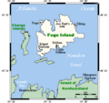
Map of Fogo Island
-
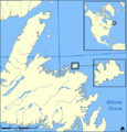
Location of Fogo Island
-
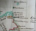
French Map (1713) of northeast Newfoundland showing Fogo Island ("Isles de Fougues")
-
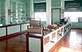
Fishermen's Union general store, Seldom-Come-By, Newfoundland
-
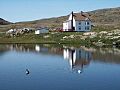
Scene from Fogo Island
-
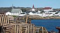
Fogo, Newfoundland
-
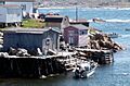
Fishing stages in Fogo, Newfoundland
-
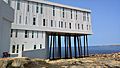
Fogo Island Inn


See also
 In Spanish: Isla Fogo (Canadá) para niños
