
Fort Chiswell, Virginia facts for kids
Quick facts for kids
Fort Chiswell, Virginia
|
|
|---|---|

Location of Fort Chiswell, Virginia
|
|
| Country | United States |
| State | Virginia |
| County | Wythe |
| Area | |
| • Total | 12.1 sq mi (31.4 km2) |
| • Land | 12.1 sq mi (31.4 km2) |
| • Water | 0.0 sq mi (0.0 km2) |
| Elevation | 2,054 ft (626 m) |
| Population
(2010)
|
|
| • Total | 939 |
| • Density | 77.6/sq mi (29.90/km2) |
| Time zone | UTC−5 (Eastern (EST)) |
| • Summer (DST) | UTC−4 (EDT) |
| ZIP code |
24360
|
| Area code(s) | 276 |
| FIPS code | 51-29040 |
| GNIS feature ID | 1495556 |
Fort Chiswell is a small community in Wythe County, Virginia, in the United States. It is known as a census-designated place (CDP). In 2010, about 939 people lived there.
Fort Chiswell is located where two major highways meet: Interstate 77 and Interstate 81. If you drive west from Fort Chiswell, you'll find a rare road setup. For a short distance, Interstate 77 North shares the road with Interstate 81 South. This is called a "double wrong-way concurrency." Drivers get back on track when they exit I-81 to continue on I-77 North towards Charleston or South towards Charlotte.

Contents
History of Fort Chiswell
The name Fort Chiswell comes from an old fort built in 1758. This fort was an important outpost during the French and Indian War. It was also very important during the American Revolutionary War. The fort guarded a small amount of lead that was used to make bullets for soldiers.
The fort was built where two important paths met: the Great Indian Warpath and the Richmond Road. It was also close to the New River. Over time, the fort fell apart. The main county offices moved to Wytheville, about 12 miles west.
During the 1970s, when Interstate 77 was built, the remaining parts of the fort were covered up. Today, there is a pyramid-shaped historical marker made of sandstone. It is about 200 yards from where the original fort stood.
Some important historical places in Fort Chiswell are listed on the National Register of Historic Places. These include the Fort Chiswell Site, The Mansion at Fort Chiswell, and the McGavock Family Cemetery.
Schools in Fort Chiswell
Fort Chiswell has both private and public schools for students. There is one private school called 'Kiddy Centre'. This school offers education for pre-school children and daycare services.
For public education, there are two schools:
- Fort Chiswell Middle School (FCMS)
- Fort Chiswell High School (FCHS)
These two schools are now located in the same building. The principals for the middle school are Tammy J. Watson and Chelsea R. Buchanan. The principals for the high school are James C. Suma and Holly L. Luper.
Geography of Fort Chiswell
Fort Chiswell is located at 36°56′37″N 80°56′25″W / 36.94361°N 80.94028°W. This means it's in a specific spot on the map.
According to the United States Census Bureau, the total area of Fort Chiswell is about 12.1 square miles (31.3 square kilometers). All of this area is land, with no large bodies of water.
Population and People
In 2000, about 911 people lived in Fort Chiswell. The area had about 75 people per square mile. Most of the people living there were White.
The community had 357 households. Many families lived together, and some households had children under 18. The average age of people in Fort Chiswell was 36 years old.
Images for kids
-
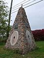
The Fort Chiswell Historic Marker near the site of the original fort in Wythe County, Virginia.
-
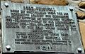
Ft. Chiswell plaque on the above Historic Marker.
-

Wilderness Road plaque on the above Historic Marker.
-
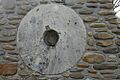
One of three millstones from the mill at old Ft. Chiswell which are mounted on the above Historic Marker.


.JPG)
See also
 In Spanish: Fort Chiswell para niños
