
Fort Providence facts for kids
Quick facts for kids
Fort Providence
Zhahti Koe, Zhahti Kue
|
|
|---|---|

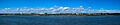
Fort Providence from the Mackenzie River
|
|

Fort Providence
Location in Northwest Territories

Fort Providence
Location in Canada
|
|
| Country | Canada |
| Territory | Northwest Territories |
| Region | South Slave Region |
| Constituency | Deh Cho |
| Census division | Region 4 |
| Hamlet | 1 January 1987 |
| Area | |
| • Land | 255.05 km2 (98.48 sq mi) |
| Elevation | 160 m (520 ft) |
| Population
(2011)
|
|
| • Total | 695 |
| • Density | 2.7/km2 (7/sq mi) |
| Time zone | UTC−07:00 (MST) |
| • Summer (DST) | UTC−06:00 (MDT) |
| Canadian Postal code |
X0E 0L0
|
| Area code(s) | 867 |
| Telephone exchange | 699 |
| - Living cost | 137.5 |
| - Food price index | 134.7 |
| Sources: Department of Municipal and Community Affairs, Prince of Wales Northern Heritage Centre, Canada Flight Supplement 2013 figure based on Edmonton = 100 2015 figure based on Yellowknife = 100 |
|
Fort Providence (Slave: Zhahti Koe, Zhahti Kue, lit. 'mission house') is a small community called a hamlet. It is located in the Northwest Territories of Canada. This hamlet is found west of Great Slave Lake.
Fort Providence has roads that are open all year. These roads connect it to the Yellowknife Highway. A big bridge, the Deh Cho Bridge, opened in 2012. It crosses the Mackenzie River near Fort Providence. This bridge replaced an ice bridge and a ferry. Now, people can cross the river any time of year.
Every August, Fort Providence hosts fun events called Mackenzie Days.
Contents
History of Fort Providence
Fort Providence started in the 1860s. It was first a Catholic mission site. A mission is a place where religious groups set up to help people.
By 1868, the Hudson's Bay Company moved its trading post here. A trading post is a place where people trade goods. Before this, their post was at Big Island. Once the trading post moved, the community became known as Fort Providence.
In 1867, a group of nuns called the Grey Nuns opened a boarding school. They also opened an orphanage in the settlement. A boarding school is where students live and study. An orphanage is a home for children who have lost their parents. The nuns mostly came from Quebec. They taught in both English and French.
Population and People
|
|||||||||||||||||||||||||||||||||||||||
|
||||||||||||||||||||||||||||||||||||||||||||||||||||||||||||||||||||||||||||||
In 2021, the Canadian Census counted 618 people living in Fort Providence. This was a small decrease from 695 people in 2016. The hamlet covers about 255 square kilometers (98 square miles) of land.
Most people living in Fort Providence are Indigenous. In 2016, about 620 residents were Indigenous. This group included 590 First Nations people, mainly Dene, and 30 Métis people.
First Nations Groups
The Dene people in Fort Providence are part of the Deh Gáh Got'ı̨ę First Nation. The Métis people are represented by the Fort Providence Métis Nation. Both of these groups belong to the larger Dehcho First Nations.
Climate and Weather
Fort Providence has a subarctic climate. This means it has very long, cold winters. Its summers are short but can be quite warm. The weather changes quickly between seasons.
| Climate data for Fort Providence, 1981–2010 normals, extremes 1943–present | |||||||||||||
|---|---|---|---|---|---|---|---|---|---|---|---|---|---|
| Month | Jan | Feb | Mar | Apr | May | Jun | Jul | Aug | Sep | Oct | Nov | Dec | Year |
| Record high °C (°F) | 7.0 (44.6) |
9.9 (49.8) |
16.5 (61.7) |
24.0 (75.2) |
31.3 (88.3) |
34.4 (93.9) |
35.2 (95.4) |
36.1 (97.0) |
30.3 (86.5) |
24.4 (75.9) |
12.8 (55.0) |
11.8 (53.2) |
36.1 (97.0) |
| Mean daily maximum °C (°F) | −18.9 (−2.0) |
−12.9 (8.8) |
−6.2 (20.8) |
5.8 (42.4) |
12.8 (55.0) |
20.9 (69.6) |
23.5 (74.3) |
20.4 (68.7) |
13.4 (56.1) |
3.2 (37.8) |
−7.7 (18.1) |
−15.1 (4.8) |
3.3 (37.9) |
| Daily mean °C (°F) | −23.4 (−10.1) |
−18.7 (−1.7) |
−13.6 (7.5) |
−1.0 (30.2) |
6.3 (43.3) |
13.5 (56.3) |
16.9 (62.4) |
14.0 (57.2) |
7.9 (46.2) |
−0.8 (30.6) |
−11.5 (11.3) |
−19.2 (−2.6) |
−2.5 (27.5) |
| Mean daily minimum °C (°F) | −27.8 (−18.0) |
−24.3 (−11.7) |
−20.9 (−5.6) |
−7.7 (18.1) |
−0.3 (31.5) |
6.0 (42.8) |
10.1 (50.2) |
7.6 (45.7) |
2.4 (36.3) |
−4.8 (23.4) |
−15.2 (4.6) |
−23.1 (−9.6) |
−8.2 (17.2) |
| Record low °C (°F) | −49.4 (−56.9) |
−50.0 (−58.0) |
−45.0 (−49.0) |
−41.1 (−42.0) |
−22.2 (−8.0) |
−5.6 (21.9) |
−2.0 (28.4) |
−2.8 (27.0) |
−14.4 (6.1) |
−27.3 (−17.1) |
−44.4 (−47.9) |
−49.4 (−56.9) |
−50.0 (−58.0) |
| Average relative humidity (%) | 74.9 | 67.6 | 53.1 | 44.4 | 41.8 | 41.7 | 47.1 | 51.4 | 57.6 | 71.3 | 84.0 | 80.2 | 59.6 |
| Source: Environment Canada | |||||||||||||
Images for kids
-
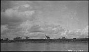
Fort Providence from the river
-
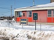
Fort Providence Health Centre
-
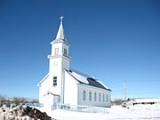
Our Lady of Providence RC Mission in Fort Providence
-
Providence Mission Indian Residential School showing new Roman Catholic Mission on the left, circa 1930
-
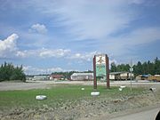
Fort Providence Deh Cho Land Use Planning Committee & Dene Fur Clouds sign
-
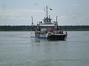
The Merv Hardie ferry in use before the bridge was opened.
-
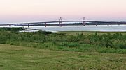
The Deh Cho Bridge


.jpg)


See also
 In Spanish: Fort Providence para niños
