Fort Rock-Christmas Lake Valley Basin facts for kids
Quick facts for kids Fort Rock-Christmas Lake Valley Basin |
|
|---|---|

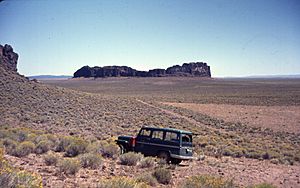
Fort Rock and its basin
|
|
| Location | Lake County, Oregon, United States |
| Coordinates | 43°18′N 121°00′W / 43.3°N 121°W |
| Elevation | 4,331–5,630 ft (1,320–1,716 m) |
| Geology | maar field |
| Age | About 50,000 to 100,000 years old |
| Last eruption | About 50,000 years ago |
The Fort Rock-Christmas Lake Valley Basin is a special area in Oregon, USA. It used to be a huge inland sea that existed for millions of years. This ancient sea was around from the Pliocene to the late Pleistocene periods.
This basin is also home to over 30 unique landforms called maars. These are wide, flat-bottomed volcanic craters. They were formed by powerful explosions when hot magma met groundwater. During the Ice Age, a giant lake called Paleolake Fort Rock covered this entire basin.
Contents
Discovering Paleolake Fort Rock
| Paleolake Fort Rock | |
|---|---|
| Lua error in Module:Location_map at line 420: attempt to index field 'wikibase' (a nil value). | |
| Location | Oregon |
| Type | Endorheic pluvial lake |
| Surface area | 2,300 kilometres (1,400 mi)2 |
| Max. depth | 75 metres (246 ft) |
| Surface elevation | 1,384 metres (4,541 ft) |
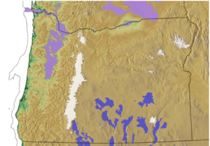
The Fort Rock Basin is a "closed basin." This means water flows into it but doesn't flow out to the ocean. During the Pleistocene Ice Age, Oregon was cooler and wetter. This extra moisture caused the ancient Paleolake Fort Rock to grow very large.
At its biggest, the lake was about 75 meters (245 feet) deep. It covered an area of over 2,300 square kilometers (900 square miles). This was much larger than any lakes in Oregon today.
Ancient Lake Levels and Shorelines
Scientists have found four main shorelines from Paleolake Fort Rock. These are like old "bathtub rings" left behind as the lake level changed. They can be seen as wave-cut terraces and old beach lines. The bottom of the Fort Rock Basin is quite flat. This means the lake's depth was pretty much the same across the basin at each level.
The highest shoreline is about 1,384 meters (4,540 feet) above sea level. At this level, the lake was about 70 meters (230 feet) deep. Two hills, Connley Hills and Buchgrass Butte, were major islands in the lake.
The next shoreline is a bit lower, at 1,364–67 meters (4,475–85 feet). The lake was about 52 meters (170 feet) deep here. Only the Connley Hills, Buchgrass Butte, and the Fort Rock tuff ring were islands.
The 1,353–1356 meter (4,440–4450 feet) shoreline is the most noticeable. This is the level that carved the famous notches in Fort Rock. It also created caves in the Connley Hills and Cougar Mountain. The lake was about 38 meters (125 feet) deep at this stage.
The lowest shoreline is at 1,332 meters (4,370 feet). At this point, the lake was much shallower, about 17 meters (55 feet) deep. It was also almost 1,000 square kilometers smaller than when it was at its highest level.
Evidence of Early People
The Fort Rock Basin is an important place for learning about early humans in Oregon. Many ancient sites have been found here.
Fort Rock Cave: Ancient Shoes
Before other discoveries, Fort Rock Cave showed the earliest signs of people living in Oregon. In 1938, a team led by Luther Cressman found many well-preserved sandals made from sagebrush bark. These sandals are the oldest footwear ever found, with the oldest ones being about 10,000 years old!
The cave is located about 2.4 kilometers (1.5 miles) west of Fort Rock. Fort Rock Cave is so important that it was named a National Historic Landmark in 1961.
Connley Caves: A Wetland Home
The Connley Caves are six rock shelters in the Connley Hills. People lived in these caves on and off from at least 11,200 years ago to 3,140 years ago. A layer of volcanic ash from the Mazama eruption, dating to 6,850 years ago, was found in all the caves.
Below this ash layer, scientists found many bones of wetland animals. These included birds like ducks and sage-grouse, small animals like rabbits and ground squirrels, and large animals like pronghorn antelope and bison. This shows that the Connley Caves area used to be a wetland. Pieces of pine wood also suggest it was cooler and wetter back then.
Tools and other items from 11,000 to 7,000 years ago show that the caves were a popular camping spot. People left behind obsidian and basalt projectile points (arrowheads or spear points), knives, scrapers, drills, and milling stones for grinding food. Research is still happening at the Connley Caves today.
Carlon and Boulder Village: Stone Houses
Carlon and Boulder Village are two sites in the Fort Rock Basin where people built houses using stones. Carlon Village has several stone house rings that you can still see on the ground. Scientists dug in three spots and found three different floor levels. These floors contained bones from fish, rodents, rabbits, and larger animals. They date back to about 2,040 to 1,780 years ago.
Boulder Village is the biggest of these stone house sites. It has 122 stone rings visible on the surface. Digs in 17 of these houses found items dating from 1,510 to 100 years ago. The tools found included projectile points, knives, and grinding tools. Seeds from plants like salt sage and juniper were also found.
Volcanic Features of the Basin
The Fort Rock-Christmas Lake Valley Basin has many interesting volcanic features.
Moffitt Butte: A Tuff Ring
Moffitt Butte is a type of volcano called a tuff ring. It's about 1,400 meters (4,600 feet) wide and 120 meters (400 feet) tall. Unlike some other features in the area, Moffitt Butte wasn't formed directly in a lake. However, rising magma likely hit underground water sources, causing explosive eruptions. The bottom of Moffitt Butte's crater is about 80 meters (260 feet) higher than the land around it.
Table Rock: A Cone with a Lava Lake
Table Rock is what's left of an ancient tuff cone. It's a cone-shaped hill about 1,500 meters (5,020 feet) wide at its base. It tapers to about 360 meters (1,180 feet) wide at its top, which is also about 360 meters (1,180 feet) above the surrounding plain.
The top of Table Rock is flat because it's capped with hard basalt rock. This basalt used to fill the volcano's crater like a lava lake. Over time, erosion has worn away the softer parts of the cone, leaving behind this flat-topped feature.
Notable Volcanic Vents
The Fort Rock-Christmas Lake Valley Basin is home to many volcanic vents. Here are some of the notable ones:
| Name | Elevation | Location | Last eruption |
| Big Hole | possibly 20,000 years ago | ||
| Black Hills | |||
| Boat-Wright Ranch | |||
| Flat Top | |||
| Flatiron | |||
| Fort Rock | 43°22′N 121°04′W / 43.37°N 121.06°W | 50,000 to 100,000 years ago | |
| Hole-in-the-Ground | 43°25′N 121°12′W / 43.41°N 121.20°W | 50,000 to 100,000 years ago | |
| Horning Bend | |||
| Moffitt Butte | 43°31′N 121°26′W / 43.51°N 121.44°W | 50,000 to 100,000 years ago | |
| Reed Rock | |||
| Ridge 28 | |||
| St. Patrick Mountain | |||
| Sand Rock | 43°22′N 120°19′W / 43.37°N 120.32°W | 50,000 to 100,000 years ago | |
| Seven-Mile Ridge | |||
| South Green Mountain | |||
| Table Mountain | |||
| Table Rock | 43°10′N 120°53′W / 43.17°N 120.88°W | 50,000 to 100,000 years ago | |
| Wastina Butte | |||
| Wildcat Butte |
 | Charles R. Drew |
 | Benjamin Banneker |
 | Jane C. Wright |
 | Roger Arliner Young |


