Fortification Hill facts for kids
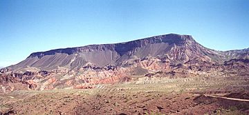
Quick facts for kids Fortification Hill( viewed from ~due west ) |
|
|---|---|
 |
|
| Highest point | |
| Elevation | 3,720 ft (1,134 m) NAVD 88 |
| Prominence | 863 ft (263 m) |
| Geography | |
| Location | Mohave County, Arizona, U.S. |
| Parent range | Black Mountains (Arizona) |
| Topo map | USGS Hoover Dam |
Fortification Hill is a cool natural landmark near Lake Mead in Arizona. It's a big hill that looks a bit like a flat-topped table, and it's part of the Black Mountains (Arizona). You can spot it easily if you're near Hoover Dam or looking across Las Vegas Bay.
Fortification Hill
Where is Fortification Hill?
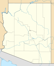
This interesting hill is located in Mohave County, Arizona, right next to the famous Lake Mead. It's part of the northern end of the Black Mountains (Arizona). If you're visiting Hoover Dam, Fortification Hill is just a short distance northeast of it. It's also easy to see from across Las Vegas Bay or from other nearby mountains like the Eldorado Mountains in Nevada.
What Does it Look Like?
Fortification Hill isn't a pointy mountain. Instead, it has a flat top, almost like a giant table or a "mesa." Its highest point is at the southeast side, and then it gently slopes down towards Lake Mead in the north and northwest. This hill stands about 3,719 feet (1,134 m) tall.
How Was it Formed?
The flat top of Fortification Hill is made of a type of rock called basaltic lava flows. This means that long, long ago, hot, melted rock (lava) flowed out of the ground and then cooled down to form these layers of rock. Over time, wind and water shaped the area, leaving Fortification Hill standing tall with its unique flat top.
 | Percy Lavon Julian |
 | Katherine Johnson |
 | George Washington Carver |
 | Annie Easley |


