Eldorado Mountains facts for kids
Quick facts for kids Eldorado Mountains |
|
|---|---|
| El Dorado Mountains | |

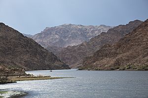
(view of east flank, north)
From the Colorado River, downstream from Willow Beach, Lake Mohave. Nevada is at right, and the prominence, forward. Arizona's (Black Mountains (Arizona) is on left bank. The view is downstream & slightly west-southwestwards. |
|
| Highest point | |
| Peak | Ireteba Peak (Eldorado Mountains) |
| Elevation | 5,060 ft (1,540 m) |
| Geography | |
| Country | United States |
| State | Nevada |
| District | Clark County |
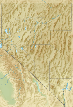
| Range coordinates | 35°48′26.944″N 114°46′57.927″W / 35.80748444°N 114.78275750°W |
| Topo map | USGS Boulder City SE |
The Eldorado Mountains, also known as the El Dorado Mountains, are a mountain range in southeastern Nevada. They stretch from north to south. These mountains are located west of the Colorado River, which flows south.
To the west of the mountains is the Eldorado Valley. This valley is an endorheic basin, which means water flows into it but doesn't flow out to the ocean. The Eldorado Mountains also sit next to the Black Canyon of the Colorado and El Dorado Canyon along the river.
The range is about 50 miles (80 km) southeast of Las Vegas, Nevada. The Eldorado Mountains are connected to the Highland and Newberry ranges.
The name El Dorado comes from a famous legend. It is about a lost city or mine full of gold. The old mining town of Nelson is found in Nelson Canyon, right in the middle of these mountains. From the Nelson Overlook, you can get a great view of the Colorado River's El Dorado Canyon.
Contents
Exploring the El Dorado Wilderness
The Eldorado Mountains are home to a special protected area called the El Dorado Wilderness. This wilderness covers a huge area of 32,060 acres (about 13,000 hectares). It was created in 2004 to protect the natural environment.
Who Manages the Wilderness?
This wilderness area is managed by two groups. The NPS takes care of the eastern part. This section is inside the Lake Mead National Recreation Area. The BLM looks after the western part of the wilderness.
What's the Landscape Like?
This desert wilderness is a rugged place. It has many hills, tall peaks, and winding canyons. The Eldorado Range is made mostly of volcanic rock. You can see basalt flows, which are hardened lava. Underneath, there's older metamorphic rock.
A gently sloping area called a bajada stretches northwest from the mountains. It's made of rock and gravel washed down from the mountains.
Plants and Animals
The mountains and their foothills are covered with desert plants. You'll find creosote bush, scrub oak, clump grass, and different kinds of cacti. These plants provide food and shelter for animals.
The wilderness is home to a good number of bighorn sheep. These amazing animals live in the higher parts of the mountains.
Challenges in the Desert
You might find old, abandoned mine sites scattered around the region. Water is very hard to find here, except for the Colorado River itself. Summers can be extremely hot, with temperatures reaching up to 120°F (48°C).
Ireteba Peak and Ridge
To the south, there's another wilderness area called the Ireteba Peaks Wilderness. It covers 32,745 acres (about 13,250 hectares). This area includes the Ireteba Ridge, which is 5,013 feet (1,528 meters) tall. From the ridge, you can look east over the northern parts of Lake Mohave and the El Dorado Canyon.
The highest point in the entire Eldorado Mountains is Ireteba Peak. It stands at 5,060 feet (1,542 meters) high. This peak is named after Irataba, a famous guide and leader of the Mohave Native American tribe.
Nearby Towns
Several communities are located near the Eldorado Mountains.
- In the south, you'll find Searchlight along US 95.
- Also in the south is Cottonwood Cove, right on the Colorado River.
- Nelson is in the central part of the range.
- The closest town to the north is Boulder City.
 | Laphonza Butler |
 | Daisy Bates |
 | Elizabeth Piper Ensley |


