
Fortune Peak facts for kids
Quick facts for kids Fortune Peak |
|
|---|---|

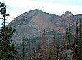
Fortune Peak, southwest aspect
|
|
| Highest point | |
| Elevation | 7,382 ft (2,250 m) |
| Prominence | 102 ft (31 m) |
| Isolation | 0.41 mi (0.66 km) |
| Parent peak | Ingalls Peak (7,662 ft) |
| Geography | |

Fortune Peak
Location in Washington (state)

Fortune Peak
Location in the United States
|
|
| Location | Chelan County/Kittitas County Washington, U.S. |
| Parent range | Wenatchee Mountains Cascade Range |
| Topo map | USGS Mount Stuart |
| Climbing | |
| Easiest route | scrambling |
Fortune Peak is a mountain in Washington state. It stands about 7,382 feet (2,250 meters) tall. This peak is located right on the border between Kittitas County and Chelan County.
Fortune Peak is the second-highest point in the Teanaway area. This area is part of the Wenatchee Mountains. The peak is found southwest of Ingalls Peak and Lake Ingalls. It sits on the edge of the Alpine Lakes Wilderness. The land around it is managed by the Wenatchee National Forest.
Water from the peak flows in different directions. It drains into Fortune Creek, which goes to the Cle Elum River. It also flows into streams that feed the Teanaway River. Some water goes into Ingalls Creek, which is part of the Wenatchee River system. The peak gets its name because it is at the start of Fortune Creek. This creek was once home to old mines like the Queen of the Hills and Ruby Mines. The Queen of the Hills mine dug for gold. The Ruby Mine found metals like antimony, copper, lead, and silver, with some gold too.
Weather Around Fortune Peak
The area near Fortune Peak is a bit drier than places to the west. This is because it's on the eastern side of the Cascade Range. Summers here can be warm, and sometimes there are thunderstorms.
Most weather systems come from the Pacific Ocean. They travel east towards the Cascade Mountains. When these systems reach the tall mountains, they are forced to rise. This causes them to drop their moisture as rain or snow on the western side of the Cascades. This process is called Orographic lift. Because of this, the eastern slopes, where Fortune Peak is, get less rain and snow. In winter, it's often cloudy. But in summer, high pressure systems over the Pacific Ocean usually bring clear skies.
How Fortune Peak Was Formed
The Alpine Lakes Wilderness has very rugged land. You can see sharp peaks, deep valleys carved by glaciers, and tall granite walls. There are also more than 700 mountain lakes.
Geological events that happened millions of years ago created this landscape. These events caused big changes in height across the Cascade Range. This also led to the different weather patterns we see today.
The Cascade Mountains started forming millions of years ago. This was during a time called the late Eocene Epoch. The North American Plate was slowly moving over the Pacific Plate. This movement caused many volcanic eruptions. Also, small pieces of the Earth's crust, called terranes, joined together. This helped form the North Cascades about 50 million years ago.
During the Pleistocene period, which was over two million years ago, glaciers moved across the land many times. They scraped and shaped the landscape. They left behind piles of rock and dirt. The last time glaciers melted away from the Alpine Lakes area was about 14,000 years ago. By 10,000 years ago, they had moved north of the Canada–US border. The river valleys in this area have a "U" shape. This shape was created by these recent glaciers.
The rising of the land (called uplift) and cracks in the Earth's crust (called faulting) worked with the glaciers. Together, these processes created the tall peaks and deep valleys you see in the Alpine Lakes Wilderness today.
Images for kids
-
Fortune Peak, southeast view

