
Forvie National Nature Reserve facts for kids
Quick facts for kids Forvie National Nature Reserve |
|
|---|---|
|
IUCN Category II (National Park)
|
|

Forvie 2013 - Cabro Aviation Ltd.
|
|

Forvie National Nature Reserve
Location in Aberdeen
|
|
| Location | Newburgh, Aberdeenshire, Scotland |
| Area | 973 ha (2,400 acres) |
| Established | 1959 |
| Governing body | NatureScot |
| Forvie National Nature Reserve | |

The Forvie National Nature Reserve is a special natural area in Scotland. It's located north of Newburgh in Aberdeenshire, which is in the northeast part of Scotland. This reserve is owned and looked after by an organization called NatureScot.
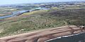
A big part of the reserve is the Sands of Forvie. This is the fifth largest sand dune system in Britain. It's also one of the most natural, meaning it hasn't been changed much by people. These sand dunes are connected to the Ythan Estuary, which is where the River Ythan meets the sea. The estuary is also part of the reserve.
Forvie used to have the biggest group of common eider ducks breeding in Britain. While their numbers have gone down since 2006, they are still an important part of the reserve. The reserve is also a key place for tern birds to nest. You can also see many seals resting on the beaches here.
This area is very important for nature. It's protected as a Special Protection Area and a Special Area of Conservation. These are special titles given under the Natura 2000 plan to protect important habitats. It's also a Site of Special Scientific Interest, meaning it's important for its plants, animals, or geology.
Long ago, there was a village called Forvie in this area. But it had to be left behind because of the moving sand dunes.
Contents
Sands of Forvie: Scotland's Shifting Dunes
The Sands of Forvie are one of Scotland's largest areas of moving sand. This sand was formed from tiny bits of rock and soil. These bits were carried by rivers to the coast at the end of the last Ice Age. Over time, waves and wind slowly pushed this sediment from the sea onto the land.
The sand dunes at Forvie have three main parts. In the south, there's a sand spit. This is a narrow piece of land that forms where the River Ythan flows into the sea. Further north, the sand sits on top of old beaches and rocky areas shaped by glaciers. Even further north, the sand covers a rocky plateau.
These dunes are always moving and can grow very tall, up to 20 meters (about 65 feet) high! Because there aren't many plants growing on these moving dunes, they can look a bit like the Sahara Desert.
Wildlife and Plants at Forvie Reserve

The Forvie reserve has many different types of natural areas. These include sandy beaches, moving and stable sand dunes, grassy dune areas, and open heathland. Many different plants grow here as the dunes change over time.
Plants of the Dunes and Heathland
The sand dunes are home to many plant species. You can find marram grass, which helps to hold the sand in place. Other plants include red fescue, crowberry, and cross-leaved heath. There are also common sedge and marsh pennywort. Some plants here are very rare or special.
Bird Life: Terns and Other Species
Four types of tern birds come to Forvie to breed. They build their nests in the dunes and on the beach. Little terns and arctic terns prefer the sandy foreshore. Sandwich terns and common terns nest among the marram grass in the dunes.
NatureScot works to help these terns. They sometimes use decoy terns to attract little terns to safe areas. They also provide small shelters for tern chicks to hide from bigger birds. In recent years, the sandwich tern and black-headed gull colonies have been very successful.
The muddy areas of the estuary are important for birds that spend the winter here. You might see wigeon, oystercatcher, golden plover, and lapwing. About 15,000 geese can be seen on the estuary each spring.
Forvie also has a protected group of eider ducks. They spend their breeding season here. While many go to the River Tay for winter, some stay all year. In 2005, there were over 5,000 eiders, but their numbers have dropped since then.
The cliffs in the northern part of the reserve are home to many nesting seabirds. These include northern fulmar, shag, cormorant, and kittiwake. You can also spot birds of prey like short-eared owls, kestrel, and buzzard. In total, 255 different types of birds have been seen at Forvie.
Seals and Other Mammals
Forvie is a great place to see grey and common seals. They often rest on the beaches and mudflats near the mouth of the Ythan estuary. To protect them, there's a special viewpoint on Newburgh beach. The seal population here is growing fast, with anywhere from 1,000 to 3,000 seals present.
Bottlenose dolphins sometimes visit the seas off Forvie. You can also find otters living along the River Ythan. Other mammals common in northeast Scotland also live here. These include roe deer, red foxes, badgers, and stoats.
History of Forvie: From Ancient Times to Today
The coast at Forvie has been used by people for a very long time. The oldest signs of human activity are from about 8,000 years ago. These include places where people worked with flint stone and piles of shell middens (old rubbish heaps).
Archaeologists have also found burial mounds from the Neolithic period (about 6,000 years ago). There are also kerb cairns from the Bronze Age, which were built to hold ashes from cremations. Other Bronze Age items found include parts of grinding stones and pottery. Remains of a small village with 31 huts, dating back to around 700 BC, have also been found.
The Lost Village of Forvie
The old village of Forvie is now covered by the sand dunes. Digs at the village church, dedicated to St Adamnan, show it was built in the 12th century. Burials in the church suggest it was already a ruin by the 15th century. Local stories say a big storm in August 1413 caused the village to be buried by sand. The area of Forvie became part of the nearby Slains parish in 1573.
In 1959, the Sands of Forvie became a national nature reserve (NNR). This was agreed between the landowners and the Nature Conservancy Council (now NatureScot). The NNR was made bigger in 1979 to include the Ythan Estuary. Later, NatureScot bought the land from the owners in 2003 and 2012.
Forvie During the World Wars
Forvie played a small part in World War I and II. Because the area looked a bit like the mouth of the River Don in Aberdeen, defenses were built here. These included small concrete shelters called pillboxes, gun batteries, and anti-tank blocks.
During World War II, the beaches at Forvie were protected with landmines. These mines were cleared after the war, but it was a difficult job because the sand was always shifting. Sadly, a soldier named Sapper Harry Dean was killed while clearing a mine in July 1944.
Forvie sands were also used to train soldiers in desert warfare. Forvie Moor was used for training with grenades and mortars. Even today, you can still see craters from these training exercises.
In November 1940, German planes dropped 30 bombs on Forvie Links. The craters from these bombs could still be seen in aerial photos years later.
One Sunday in November 1941, three local boys found an unexploded anti-tank grenade. One of the boys, Alex Ross, threw it away, and it exploded, causing him to lose sight in one eye.
In March 1941, a British ship called the Melrose Abbey ran aground nearby. It was later hit by a drifting sea mine. A machine gun was placed at Forvie Sands to protect the ship while plans were made to move it.
Visiting Forvie National Nature Reserve
About 35,000 people visit the Forvie National Nature Reserve each year. The Stevenson Forvie Centre, near Collieston, helps visitors learn about the reserve. It opened in the 1980s and was improved in 1998 with money from Shell and a gift from a local person, Margaret Stevenson, who the center is named after.
There are two marked paths for visitors to explore the reserve.
- The 5.5 km (about 3.4 miles) Dune Trail is a circular path. It takes you through the sand dunes and to the beach. You'll pass the site of the old abandoned village and the ruins of the church.
- The 3.4 km (about 2.1 miles) Heath Trail is also a circular path. It starts and ends at the visitor center and goes through the heathland in the northern part of the reserve.
You can connect these two paths with a path that runs along the seafront.
Images for kids
-
Minefield start / end from Royal Engineers file in TNA - Kew

