Foxfield, Colorado facts for kids
Quick facts for kids
Foxfield, Colorado
|
|
|---|---|
| Town of Foxfield | |

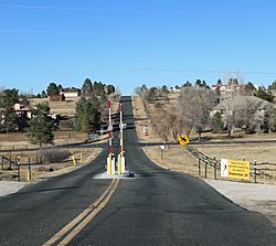
Looking north along South Richfield Street in Foxfield
|
|

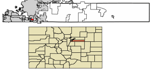
Location of the Town of Foxfield in Arapahoe County, Colorado.
|
|
| Country | |
| State | |
| County | Arapahoe County |
| Incorporated | December 15, 1994 |
| Government | |
| • Type | Statutory Town |
| Area | |
| • Total | 1.323 sq mi (3.427 km2) |
| • Land | 1.323 sq mi (3.427 km2) |
| • Water | 0 sq mi (0.000 km2) |
| Elevation | 5,755 ft (1,754 m) |
| Population
(2020)
|
|
| • Total | 754 |
| • Density | 570/sq mi (220/km2) |
| • Metro | 2,963,821 (19th) |
| • CSA | 3,623,560 (17th) |
| • Front Range | 5,055,344 |
| Time zone | UTC−07:00 (MST) |
| • Summer (DST) | UTC−06:00 (MDT) |
| ZIP code |
80016
|
| Area code(s) | Both 303 and 720 |
| FIPS code | 08-28105 |
| GNIS feature ID | 1669465 |
The Town of Foxfield is a small town in Arapahoe County, Colorado, United States. It is a special type of town called a "statutory town." In 2020, about 754 people lived there.
Foxfield is part of a larger area called the Denver–Aurora–Lakewood, CO Metropolitan Statistical Area. This means it's connected to the bigger cities of Denver, Aurora, and Lakewood. The town is also part of the Front Range Urban Corridor, a long area where many cities are located. Foxfield is next to the cities of Aurora and Centennial.
Where is Foxfield?
Foxfield is located in Colorado at specific coordinates: 39 degrees, 35 minutes, 12 seconds North and 104 degrees, 47 minutes, 15 seconds West. These numbers help pinpoint its exact spot on a map.
The town is quite small in size. According to the 2020 United States Census, Foxfield covers an area of about 3.427 square kilometers (which is about 1.32 square miles). All of this area is land, with no large bodies of water inside the town limits.
How Many People Live in Foxfield?
| Historical population | |||
|---|---|---|---|
| Census | Pop. | %± | |
| 2000 | 746 | — | |
| 2010 | 685 | −8.2% | |
| 2020 | 754 | 10.1% | |
| U.S. Decennial Census | |||
The number of people living in Foxfield has changed a bit over the years.
- In 2000, there were 746 people.
- By 2010, the population went down slightly to 685 people.
- In 2020, the population grew again to 754 people.
In 2000, there were 247 households in Foxfield. A household is like a home where people live. Most of these households (218 of them) were families. The town had about 578 people per square mile.
Most people living in Foxfield in 2000 were White (about 93.7%). A smaller number were African American (2.68%) or Asian (1.34%). About 2.28% of the people were from two or more racial backgrounds. Around 2.82% of the population identified as Hispanic or Latino.
Many households (38.9%) had children under 18 living with them. Most households (84.2%) were married couples living together. The average household had about 2.98 people.
The age of people in Foxfield in 2000 was spread out:
- 28.2% were under 18 years old.
- 5.4% were between 18 and 24.
- 17.7% were between 25 and 44.
- 39.0% were between 45 and 64.
- 9.8% were 65 years or older.
The average age in Foxfield was 44 years old.
In 2000, the average income for a household in Foxfield was $109,507 per year. For families, the average income was $117,255. The average income per person in the town was $40,970. A small number of families (2.7%) and people (4.4%) were living below the poverty line.
Education in Foxfield
Children in Foxfield attend schools that are part of the Cherry Creek School District 5.
The specific schools for students in Foxfield are:
- Creekside Elementary School
- Liberty Middle School
- Grandview High School
See also
 In Spanish: Foxfield para niños
 | Isaac Myers |
 | D. Hamilton Jackson |
 | A. Philip Randolph |


