Gaudineer Scenic Area facts for kids
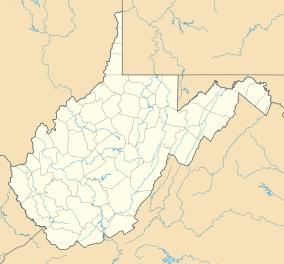
The Gaudineer Scenic Area (often called GSA) is a special natural place. It's a National Natural Landmark located within the Monongahela National Forest (MNF). You can find it in West Virginia, USA. It's near Gaudineer Knob on Shavers Mountain. The area sits on the border of Randolph and Pocahontas Counties. It's about 5 miles (8.0 km) (8 km) northwest of Durbin.
Contents
What Makes Gaudineer Scenic Area Special?
The Gaudineer Scenic Area is part of the Greenbrier Ranger District. This district is located within the larger Monongahela National Forest. The GSA is found near the top of Shavers Mountain. It is just north of Gaudineer Knob, which is the mountain's highest point. Gaudineer Knob reaches 4,432 feet (1,351 m) (1,351 m) high. The Scenic Area itself is at an elevation of about 4,000 feet (1,200 m) (1,219 m).
Forest Types and Trees
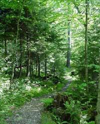
The total area of the GSA is 140 acres (570,000 m2) (0.57 km²). About 50 acres (200,000 m2) (0.20 km²) of this land is an old-growth red spruce forest. "Old-growth" means these trees have never been cut down. Some trees in this part of the forest are very old. They can be over 300 years old. Their trunks can be as wide as 40 inches (1,000 mm) (100 cm) across at chest height.
The other 90 acres (360,000 m2) (0.36 km²) of the area has been carefully managed. Only broken branches or damaged trees have been removed. This is called "selective timber harvesting." Besides red spruce, the GSA also has other native hardwood trees. These include red maple, sugar maple, yellow birch, and beech trees. Experts from the Forest Service believe the entire 140 acres (570,000 m2) area holds a lot of wood. They estimate it's about 1,500,000 board feet (3,500 m3) (3,500 m³).
How the Gaudineer Scenic Area Was Saved
The land around the Gaudineer Scenic Area was once heavily logged. Between 1900 and 1920, a company called the West Virginia Pulp and Paper Company cut down most of the trees. Their main base was in Cass. However, a small part of the original forest was saved. This happened because of an old mistake!
A Lucky Mistake
Many years before the Civil War, a land company bought a huge piece of land. It was about 69,000 acres [280 km2] (279 km²) on Shavers Mountain. They hired a team to survey the land. This means they measured and marked its boundaries. The wilderness made their job very difficult. The team did a good job, but they forgot one important thing. A compass needle points to magnetic north, not true north. In this area, the compass was off by about four degrees. This small error caused a big problem over a seven-mile (11 km) distance.
An experienced surveyor from Virginia later found this mistake. He kept it a secret at first. But when the land sale was almost finished, he revealed the error. Because of this mistake, a wedge-shaped strip of land was left over. This strip was about seven miles long and almost 900 acres [3.6 km2] (3.6 km²) in size. The surveyor was able to claim this land for himself. While trees all around this strip were cut down, this narrow piece of forest remained untouched. The thickest part of this untouched forest is just east of Gaudineer Tower. The trees here helped new forests grow. This happy result came from a hundred-year-old mistake!
Protecting the Forest
Later, the U.S. Forest Service bought this special piece of land. This happened because Arthur A. Wood, who used to be in charge of the Monongahela National Forest, insisted on it. He believed that future generations should see what an Appalachian spruce forest looked like naturally.
In October 1964, the Forest Service officially named this area a Scenic Area. They began to manage it to protect its beauty. In December 1974, the Gaudineer Scenic Area was given another important title. It was named a National Natural Landmark. This means it has exceptional natural value. In May 1983, the Society of American Foresters also recognized it. They registered it as an excellent example of a natural plant community. It is now used for scientific study and education.
 | Lonnie Johnson |
 | Granville Woods |
 | Lewis Howard Latimer |
 | James West |


