Geography of North Dakota facts for kids
The geography of North Dakota describes the land and features of this U.S. state. North Dakota has three main land regions. In the east, you'll find the flat Red River Valley. To its west is the Missouri Plateau. The southwestern part of the state is covered by the Great Plains, which includes the unique Badlands.
North Dakota is about 340 miles (545 km) from east to west. It is also about 211 miles (340 km) from north to south. The state covers a total area of 70,704 square miles (183,123 km²). This makes it the 19th largest state in the United States. About 2.4% of North Dakota's land is covered by water.
Contents
North Dakota's Main Land Regions
The Red River Valley
The Red River Valley is in the eastern part of North Dakota. The Red River of the North forms the border with Minnesota here.
This valley is actually the old lakebed of a huge ancient lake called Lake Agassiz. Because of this, the land is very flat and super fertile. This area is mostly farmland. Farmers here grow crops like wheat, sugarbeets, and maize (corn). They also raise livestock. The lowest point in North Dakota is found in this valley. It's the Red River at Pembina, which is 750 feet (230 m) above sea level.
The Missouri Plateau and Drift Prairie
West of the Red River Valley, you'll find the Drift Prairie and the Missouri Plateau. The Drift Prairie is next to the Turtle Mountains in the north. The Pembina Hills separate it from the Red River Valley. This area rises from 200 to 2,000 feet higher than the Red River Valley.
The Drift Prairie has many lakes, stream valleys, and rolling hills. This region often experiences flooding from the Red River. This happens almost every year due to heavy snowfall in winter.
The Great Plains
About half of North Dakota is part of the Great Plains. This region is in the southwestern section of the state. It has rolling hills and is rich in different minerals.
This area rises about 300 to 400 feet above the Drift Prairie. The land is lower along the Missouri River. This lower area is known as the Missouri Break. South and west of the river, the land becomes rugged. It has many valleys and buttes. This part is called the Slope.
The Badlands
The Badlands are located in southwestern North Dakota. They are areas where stone and clay surfaces are exposed. Erosion has shaped these surfaces into amazing formations. You can see many shades of browns, reds, grays, and yellows. These colors appear in buttes, pyramids, domes, and cones.
The Badlands stretch for about 190 miles (305 km). They are typically 6 to 20 miles (10 to 30 km) wide. In some parts of the Badlands, the rocks contain lignite coal. This coal has been burning underground for many years. The clay above these burning coal beds has turned bright pink and red. White Butte, the highest point in North Dakota, is in the Badlands. It stands 3506 feet (1069 m) above sea level.
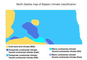
Climate
Important Geographic Points
Extreme points
These are the very edges of North Dakota:
- Northernmost point: The border with Saskatchewan and Manitoba at 49° N latitude.
- Southernmost point: The border with South Dakota at the Bois de Sioux River, 45°56'07" N.
- Easternmost point: The Bois de Sioux River near Fairmount.
- Westernmost point: The border with Montana and Saskatchewan, 104° 02' 46" W.
Physiographic points
These are important land features:
- Highest point: White Butte, which is 3507 feet (1069 m) tall.
- Lowest point: The Red River of the North at Pembina, at 750 feet (230 m) above sea level.
- Most prominent point: Boundary Butte, in the Turtle Mountains. It has an elevation of 2541 feet (774 m).
 | Aurelia Browder |
 | Nannie Helen Burroughs |
 | Michelle Alexander |


