
Giant Mountains facts for kids
Quick facts for kids Giant Mountains |
|
|---|---|
| Krkonoše / Karkonosze | |

Sněžka – the highest peak of the Giant Mountains
|
|
| Highest point | |
| Peak | Sněžka / Śnieżka |
| Elevation | 1,603 m (5,259 ft) |
| Naming | |
| Etymology | "Giant"+"Mountains" (see Names) |
| Geography | |
| Countries | Czech Republic and Poland |
| Range coordinates | 50°46′N 15°37′E / 50.767°N 15.617°E |
| Geology | |
| Orogeny |
|
| Age of rock | Neoproterozoic and Paleozoic |
| Type of rock |
|
The Giant Mountains, also known as Krkonoše (in Czech) or Karkonosze (in Polish), are a mountain range. You can find them in the northern Czech Republic and southwestern Poland. They are part of the Sudetes mountain system. The border between the Czech Republic and Poland runs along the main ridge of these mountains. This border also divides the historic regions of Bohemia and Silesia.
The highest point in the Giant Mountains is Sněžka, which is also the highest peak in the Czech Republic. It stands tall at 1,603 metres (5,259 ft). Both countries have made large parts of these mountains into national parks. The Czech Republic has the Krkonoše National Park, and Poland has the Karkonosze National Park. Together, they form a special Krkonoše/Karkonosze Transboundary Biosphere Reserve recognized by UNESCO. The famous River Elbe even starts here! These mountains are a popular spot for tourists. People love to come here for skiing, hiking, and cycling.
Contents
- Mountain Names: What They Mean
- Exploring the Geography of the Giant Mountains
- Highest Peaks and Interesting Mountains
- Plant Life in the Giant Mountains
- National Parks and Protected Areas
- Mountain Climate: Weather in the Giant Mountains
- A Brief History of the Giant Mountains
- Mountain Huts and Rock Formations
- Tourism and Activities in the Giant Mountains
- Legends and Stories
- Important Towns to Visit
- Images for kids
- See also
Mountain Names: What They Mean

People have called these mountains the Giant Mountains in English for a long time, since at least 1719. The Czech name "Krkonoše" was first written down in 1492. It appeared on a map in 1518 as "Krkonoss".
One idea for the name's meaning comes from old Slavonic words. "Krk" or "krak" meant a type of twisted tree found there. "Noš" came from a word meaning "to carry." So, it could mean "carrying twisted trees." Another idea connects it to an ancient word, "Corconti," which might have been the name of a group of people living there long ago.
Over time, many different names were used for these mountains. In 1380, someone called them the "Snowy Mountains." A writer in 1679 noted that people used names like Krkonoše, Obrovski Mountains (Giant Mountains), and Snow Mountains. The names we use today, Krkonoše (Czech), Riesengebirge (German), and Karkonosze (Polish), became common in the 1800s.
Exploring the Geography of the Giant Mountains

The Giant Mountains cover about 631 square kilometres (244 square miles). Most of this area, 454 square kilometres (175 square miles), is in the Czech Republic. The rest, 177 square kilometres (68 square miles), is in Poland. While many mountains in the Sudetes are medium-sized, the Giant Mountains have features like very high mountains. These include glacial cirques (bowl-shaped valleys carved by glaciers) and peaks that rise above the tree line (where trees can no longer grow).
The main ridge of the mountains runs from east to west. This ridge forms the border between the Czech Republic and Poland. Sněžka-Śnieżka, the highest peak, is on this ridge. The northern part, in Poland, drops steeply down to the Jelenia Góra valley. The southern part, in the Czech Republic, slopes gently. To the west, the mountains connect to the Jizera Mountains.
The Czech side also has a second ridge, called the Bohemian ridge. The Elbe River flows through and divides this ridge at Špindlerův Mlýn.
Rivers and Waterfalls in the Mountains

Rivers like the Elbe, Mumlava, and Jizera flow through the valleys, separating the mountain ridges. On the Czech side, many rivers create beautiful waterfalls. The Labský vodopád is 50 metres (160 feet) tall. The Pančavský waterfall is the tallest in the Czech Republic at 140 metres (460 feet). The Mumlavský waterfall is 10 metres or 33 feet high.
On the Polish side, important rivers include Kamienna, Łomnica, and Bóbr. They also have impressive waterfalls. The Wodospad Kamieńczyka is 27 metres or 89 feet tall. The Wodospad Szklarki is 13.5 metres or 44 feet high.
The main ridge of the Giant Mountains acts as a watershed. This means that rivers on the south side flow towards the North Sea. Rivers on the north side flow towards the Baltic Sea.
Highest Peaks and Interesting Mountains
Many peaks in the Giant Mountains are popular for hiking and offer amazing views.
| Czech Name | Polish Name | German Name | Height | Notes |
|---|---|---|---|---|
| Sněžka | Śnieżka | Schneekoppe | 1,603 m (5,259 ft) | Highest peak; you can take a lift from Pec pod Sněžkou |
| Luční hora | Łączna Góra | Hochwiesenberg | 1,555 m (5,102 ft) | Highest peak of the Bohemian Ridge |
| Studniční hora | Studzienna Góra | Brunnberg | 1,554 m (5,098 ft) | |
| Vysoké kolo | Wielki Szyszak | Hohes Rad | 1,509 m (4,951 ft) | Highest peak in the Western Krkonoše |
| Stříbrný hřbet | Smogornia | Mittagsberg | 1,489 m (4,885 ft) | |
| Violík (Labský štít) | Łabski Szczyt | Veilchenstein | 1,472 m (4,829 ft) | |
| Malý Šišák | Mały Szyszak | Kleine Sturmhaube | 1,440 m (4,720 ft) | |
| Kotel | Kocioł | Kesselkoppe | 1,435 m (4,708 ft) | |
| Velký Šišák (Smělec) | Śmielec | Große Sturmhaube | 1,424 m (4,672 ft) | |
| Harrachovy kameny | Harrachowskie Kamienie | Harrachsteine | 1,421 m (4,662 ft) | |
| Mužské kameny | Czeskie Kamienie | Mannsteine | 1,416 m (4,646 ft) | |
| Dívčí kameny | Śląskie Kamienie | Mädelsteine | 1,414 m (4,639 ft) | |
| Svorová hora | Czarna Kopa | Schwarze Koppe | 1,411 m (4,629 ft) | |
| Růžová hora | Rózowa Góra | Rosenberg | 1,390 m (4,560 ft) | |
| Kopa | Kopa | Kleine Koppe | 1,377 m (4,518 ft) | |
| Liščí hora | Lisia Góra | Fuchsberg | 1,363 m (4,472 ft) | |
| Jínonoš | Szrenica | Reifträger | 1,362 m (4,469 ft) | Chairlift from Szklarska Poręba |
| Lysá hora | Łysa Góra | Kahler Berg | 1,344 m (4,409 ft) | Chairlift from Rokytnice nad Jizerou, ski resort |
| Stoh | Stóg | Heuschober | 1,315 m (4,314 ft) | |
| Černá hora | Czarna Góra | Schwarzenberg | 1,299 m (4,262 ft) | Cable car from Janské Lázně, TV tower, ski resort |
| Medvědín | Medwiedin | Schüsselberg | 1,235 m (4,052 ft) | Chairlift from Špindlerův Mlýn, ski resort |
| Dvorský les | Dworski Las | Hoflbusch | 1,036 m (3,399 ft) | Highest peak of Rýchory |
| Čertova hora | Czarcia Góra | Teufelsberg | 1,021 m (3,350 ft) | Chairlifts from Harrachov and Rýžoviště, ski resort |
Plant Life in the Giant Mountains

The lower parts of the mountains have river valleys and forests. Many of the original hardwood forests have been replaced by spruce trees. You can still find some original hardwood forests in the river valleys.
Higher up, you'll find the montane vegetation zone. Here, too, many natural evergreen forests were replaced by spruce trees. Sadly, these trees have been damaged by air pollution and acid rain. This area is near the "Black Triangle," a region with many coal power plants. While pollution has decreased since the 1990s, the damage to the forests, which started in the 1970s, is still visible.
Long ago, people cleared forests around mountain huts to create meadows for grazing animals. These meadows were full of different plant species. After 1945, this farming stopped, and many meadows were left to grow wild.

Above the tree line, at about 1,250 to 1,350 m (4,100 to 4,430 ft), is the subalpine zone. Here, you'll see krummholz (small, twisted trees), grassy meadows, and high bogs. This area is special because it's like a small piece of Arctic tundra, left over from the Ice Age. You can find plants here that normally grow thousands of kilometers apart, like cloudberries. Some unique plant species have even developed here, found nowhere else in the world.
The highest peaks, like Sněžka and Luční hora, are in the alpine vegetation zone. This area is mostly rocky. Only tough plants like grass, moss, and lichen can survive here.
Glacial cirques, like Obří důl and Śnieżne Kotły, are especially rich in plant life. These areas are sometimes called "zahrádka" (garden) because of their many species. There are about 15 such "gardens" in the Krkonoše.
National Parks and Protected Areas

Both the Czech and Polish sides of the Giant Mountains have large areas protected as national parks and nature reserves.
The Czech Krkonoše National Park (KRNAP) was created in 1963. It was the second national park in what was then Czechoslovakia. It covers about 370 square kilometres (140 sq mi). This includes not only the high mountain areas but also parts down to the foot of the mountains.
Poland's Karkonosze National Park (KPN) was created in 1959. It covers 55.8 square kilometres (21.5 square miles). This park protects the sensitive higher parts of the mountains, starting from about 900 to 1,000 metres (3,000 to 3,300 feet) in altitude.
The Polish park has strict rules against replanting damaged forests. However, on the Czech side, large projects are underway to replant trees in areas where forests have died.
Mountain Climate: Weather in the Giant Mountains

The weather in the Giant Mountains changes often. Winters are very cold, and snow can be more than 3 metres (9.8 feet) deep. Many parts of the mountains are covered in snow for five or six months each year. High up, you'll often find thick fog.
Mount Sněžka/Śnieżka is often hidden by fog or clouds, about 296 days a year. Its average temperature is around 0.2 °C, which is similar to places much further north, like Iceland. The main ridge is one of the windiest places in Europe. On the northern side, a warm, dry wind called Foehn is common.
The amount of rain and snow (precipitation) varies. It's about 700 millimetres (28 inches) at the foot of the mountains and up to 1,230 millimetres (48 inches) on Sněžka/Śnieżka. The snow pits in the valleys get the most precipitation, around 1,512 mm (59.5 in).
A Brief History of the Giant Mountains

For a long time, the Giant Mountains were wild and empty, covered in thick forests. The first people likely settled in the foothills around the 12th century.
In the 13th century, Slavonic settlers arrived in the lowlands. Later, in the late 13th century, German settlers came. They first settled the northern Polish side, where farming was easier. Then they moved to the southern Czech side. Many towns and farming communities were started during this time.
The first people to explore the inner mountains were treasure hunters and miners. They searched for gold, silver, and valuable stones, mostly on the Polish side. In the 14th and 15th centuries, foreigners called "Wallen" came looking for treasures. Their journeys were written down in "Wallenbüchern" (Wallen books).
In the early 1500s, German miners began working near Sněžka. Many other mines opened in the central parts of the mountains.

In the 1530s, Christopher von Gendorf, a nobleman, took charge of the Vrchlabí area. He helped develop the region by founding small towns for miners. Ironworks were built in the valleys, using water wheels for power. This economic activity led to the first areas of forest being cleared on the hillsides.
In 1566, Gendorf invited lumberjacks from the Alps to settle here. These people from Tyrol and other regions changed the mountains a lot. They built new settlements, started cattle farming, and built wooden dams. By the 1600s, the mountains were well-populated with meadows and small cottages called "Baude" (or "bouda" in Czech). These were used by shepherds in summer and sometimes even in winter.

After World War II, many German residents were asked to leave. Poles, some of whom had been displaced from other areas, resettled the northern side. Czechs resettled the southern side. Today, the population in the national park area is much lower than before the war. Many houses are now used only for weekend holidays. This change also affected the cultural landscape. Many meadows were abandoned, and traditional houses and memorials were lost or changed. New Polish names were given to many mountain peaks.
Mountain Huts and Rock Formations

The Giant Mountains are known for their many mountain huts. They are called bouda in Czech, Baude in German, and schronisko in Polish. These huts were often named after their location or the people who built them. Many were originally used by shepherds as shelters.
After 1800, some huts became popular with hikers and were turned into hostels. They were often made bigger to host more guests. Famous historical huts include Luční bouda and Martinova bouda in the Czech Republic. In Poland, there are Schronisko Strzecha Akademicka and Schronisko Samotnia. Some old huts have been replaced by newer buildings built for tourists.
You can also find amazing rock formations in the mountains. Examples include Dívčí kameny-Śląskie Kamienie and Mužské kameny-Czeskie Kamienie. These are weathered granite blocks that look like tall towers, sometimes resembling people or animals. They can be up to 30 metres (98 feet) tall.
Tourism and Activities in the Giant Mountains
.jpg)
The Giant Mountains have been a popular tourist spot for a long time. Even in the 18th and 19th centuries, people like Johann Wolfgang Goethe climbed Sněžka. Artists like Caspar David Friedrich came here for inspiration.
In the late 1800s, two mountain clubs were formed. Their goal was to develop tourism, mainly by building hiking trails. They created a network of 3,000 kilometres (1,900 miles) of trails. This made the mountains a very popular vacation spot in the German Empire. Many wealthy people from Berlin built holiday homes here. Direct train links and even air links made it easy for people to visit.
After 1945, new ski resorts were built. However, many traditional mountain huts were neglected. Some were destroyed by fires. Many hiking trails also fell into disrepair. The "Polish–Czech Friendship Trail" along the main ridge was closed for a while in the 1980s. Today, the Giant Mountains are a popular place for holidays in both summer and winter.
Winter Sports: Skiing and Sledding
The Giant Mountains are a traditional center for winter sports in Central Europe. The biggest ski resorts are in places like Pec pod Sněžkou, Špindlerův Mlýn, and Harrachov in the Czech Republic. In Poland, popular resorts include Szklarska Poręba and Karpacz.
Sledding has a long history here. Heavy sleds were used to transport timber and hay. Smaller, faster sleds called "Hitsch'n" were used to get down the mountains quickly. Sled races became a popular pastime for locals and tourists.
Nordic skiing became popular around 1891, after a book about skiing across Greenland was translated. The first ski factory in Austria-Hungary was even set up here. Skiing grew thanks to forest rangers, teachers, and business people who helped fund the necessary equipment and infrastructure.

Around 1900, many sports clubs were formed. The Giant Mountains became a key place for national and international competitions. Athletes from this region were among the best of their time. For example, the first German Nordic combined champion was from here. The first "Rendezvous race," a type of Nordic Ski Championship, was held in Johannisbad.
Hiking Adventures
The "Polish–Czech Friendship Trail" is a popular cross-border hiking path. It runs along the main ridge of the mountains. The trail is about 30 kilometres (19 mi) long and offers a moderate challenge. It sometimes shares paths with ski trails. The mountains are also part of the longer Główny Szlak Sudecki hiking trail.
Mountain Biking and Cycling
The Karkonosze National Park has hundreds of kilometers of trails for cycling and mountain biking. You can find natural single tracks and challenging downhill courses. These trails cross the borders between Poland and the Czech Republic. They offer beautiful views of forests, green pastures, lakes, and rivers.
Legends and Stories
The Giant Mountains are famous as the home of Rübezahl. He is a legendary goblin from German folklore. Rübezahl is sometimes mischievous but also friendly.
The mountains are also the setting for a story by Friedrich de la Motte Fouqué called "The Shepherd of the Giant Mountains."
Important Towns to Visit
- Harrachov in the Czech Republic
- Karpacz, a ski resort in Poland
- Kowary in Poland
- Janské Lázně in the Czech Republic
- Pec pod Sněžkou, a mountain resort in the Czech Republic
- Szklarska Poręba, a ski resort in Poland
- Špindlerův Mlýn, a mountain resort in the Czech Republic
Images for kids
-
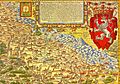
Riſenberg on Martin Helwig's map of Silesia, 1561
-
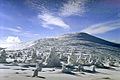
Mały Szyszak, view from Tępy Szczyt
-
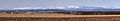
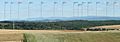
Panorama of the Giant Mountains from the south (from the Czech Republic)
-
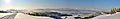
Panorama of Giant Mountains from the north (from Poland) in winter
-
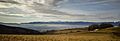
Panorama of Giant Mountains from the north (from Poland) in summer
-
Panorama of Giant Mountains from the north (from Poland) in winter
-
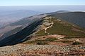
Alpine vegetation zone at the main ridge 1,400 m (4,600 ft)


See also
 In Spanish: Montañas de los Gigantes para niños
- Grzbiet Lasocki
