Girls Mountain facts for kids
Quick facts for kids Girls Mountain |
|
|---|---|

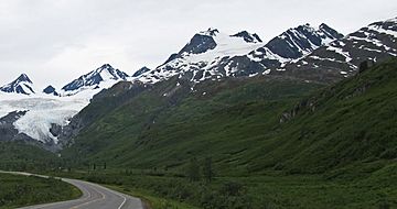
Girls Mountain centered, from the east.
(Worthington Glacier to left) |
|
| Highest point | |
| Elevation | 6,134 ft (1,870 m) |
| Prominence | 934 ft (285 m) |
| Isolation | 1.85 mi (2.98 km) |
| Geography | |
| Location | Valdez-Cordova Borough Alaska, United States |
| Parent range | Chugach Mountains |
| Topo map | USGS Valdez A-5 |
| Climbing | |
| First ascent | 1957 |
Girls Mountain is a tall, icy mountain peak in Alaska, United States. It stands about 6,134 feet (1,870 meters) high. This mountain is part of the amazing Chugach Mountains.
You can find Girls Mountain about 18 miles (29 km) east of Valdez. It is also near Thompson Pass and the Richardson Highway. Water from the mountain's melting glaciers flows into rivers. This water eventually joins the large Copper River system.
History of Girls Mountain
The name "Girls Mountain" became official in 1964. It was named by the United States Board on Geographic Names. The idea for the name came from a special marker. This marker was placed on the mountain's top in 1957. It was called "Station Girls, 1957."
The very first time someone climbed Girls Mountain was in 1957. This climb was made by Austin Post and his team. They were from the United States Geological Survey (USGS). They were the ones who put the "Station Girls" marker on the peak.
Climate and Glaciers
Girls Mountain has a very cold climate. This type of weather is called a polar climate. It means the winters are long, very cold, and full of snow. The summers are cool, but not warm.
Temperatures on the mountain can drop below -20 °C (-4 °F). With the wind, it can feel even colder, sometimes below -30 °C (-22 °F). This cold weather helps keep the big Worthington Glacier and Tsina Glacier icy. If you want to see the mountain or climb it, May and June usually have the best weather.
 | Ernest Everett Just |
 | Mary Jackson |
 | Emmett Chappelle |
 | Marie Maynard Daly |


