
Kitwanga facts for kids
Quick facts for kids
Kitwanga
Gitwangak
|
|
|---|---|

Gitwangak Battle Hill, Kitwanga, 2017.
|
|

Kitwanga
Location in British Columbia
|
|
| Country | Canada |
| Province | British Columbia |
| Region | Skeena |
| Regional district | Kitimat–Stikine |
| Area | |
| • Total | 17.6 km2 (6.8 sq mi) |
| Population
(2021)(indigenous only)
|
|
| • Total | 450 |
| • Density | 25.6/km2 (66.2/sq mi) |
| Time zone | UTC-8 (PST) |
| • Summer (DST) | UTC-7 (PDT) |
| Area codes | 250, 778, 236, & 672 |
| Highways | |
| Waterways | Skeena River Kitwanga River |
Kitwanga (also known as Gitwangak) is a community located in the Skeena region of west-central British Columbia, Canada. It sits on the north bank of the Skeena River, near where the Kitwanga River joins it. The area is surrounded by the Hazelton and Buckley Mountain Ranges.
You can reach Kitwanga by road on BC Highway 37, just northeast of its meeting point with BC Highway 16. It's about 115 kilometers (71 miles) northwest of Smithers and 99 kilometers (62 miles) northeast of Terrace.
The First Nations part of Kitwanga is managed by the Gitwangak Band Council. Next to it, the freehold part is a community that isn't officially part of a city or town.
Contents
What's in a Name?
The name Gitwangak means "place of rabbits." It was once known as Kitwanga, and you might see it spelled in other ways like Gitwangar or Kitwangagh.
Exploring Gitwangak Battle Hill
Gitwangak Battle Hill is a very important historical site. It's a hilltop fort that was used by the Gitwangak people.
The Legend of Nekt
An old legend tells the story of Lutraisuh, a noble woman who was taken by a Haida war party. She had three sons with a blind chief. Lutraisuh later escaped with her youngest son, Nekt.
Nekt grew up to be a strong warrior. He even killed a grizzly bear and used its hide, lined with slate, to make simple armor. His people built a fort on a hilltop, which they used for battles. Nekt was so fierce that his enemies thought he was a mythical bear that couldn't be killed. His special war club was called "Strike-Only-Once." Sadly, he was eventually killed by one of the first firearms in the area.
The Hilltop Fort (Ta’awdzep)
The Gitwangak hilltop fort, called Ta’awdzep, became a national historic site in 1971. It was burned and left empty around 1835. People lived at this fort from at least the mid-1700s.
The fort was surrounded by strong fences called Palisades. Inside, there were five longhouses, which were large homes for many families. Today, no structures from the fort remain above ground.
From this fort, the Gitwangak people would launch raids on other settlements along the Skeena River and the coast. They fought to control good fishing spots, protect their trade routes, and gain respect for their tribe. They even had a clever defense system: logs designed to roll down the hill onto attackers! The fort's location gave them a great view over the nearby Kitwankul Trail and the Kitwanga River Valley.
Life in the Gitwangak Reserve

After leaving the fort, the Gitwangak people moved to another village briefly before settling at their current location by the river.
The Story of Totem Poles
The beautiful totem poles you see in Kitwanga were put up between 1840 and 1942. They tell the stories of the fort and the history of the Gitwangak people. Many photos from 1899 to the early 1980s show these poles.
There have been several projects to restore and care for the totem poles. From 1924 to 1926, a lot of work was done on both standing and fallen poles. Between 1926 and 1942, some poles were moved from the river's edge to the center of the village. Another restoration project happened in the summer of 1969. Unfortunately, many poles have been lost to fire, both on purpose and by accident.
Famous painters like Emily Carr (in 1912 and 1926) and George Pepper (in 1929) painted these poles. One pole even appeared on a postage stamp in 1930!
Community and Services
Gitwangak is one of six communities that are part of the Gitxsan group of First Nations.
An Anglican mission was started here by Rev. Alfred Edward Price, who was in charge from 1889 to 1911. The church also ran a day school on the reserve from 1898 to 1975. In the winter of 1887, a measles sickness spread quickly because people were traveling for cultural events.

The bell tower of St. Paul's Anglican Church was replaced in 1974 because it was old and rotting. The church itself, built in 1893, was destroyed by fire in 2021. The nearby bell tower was saved, even though it had some fire damage.
In 2009, the community hall received major updates thanks to funding and volunteers. Gitwangak has its own health services and a volunteer fire department. In 2023, a new childcare center opened, offering over 50 spaces for kids. Also, a two-story apartment building with 52 units was completed, providing affordable homes.
At the meeting point of highways 37 and 16, there's a Petro-Canada station on reserve land. It offers fuel, a small repair shop, a restaurant, and a convenience store.
Kitwanga's Roads and Travel
Kitwanga has seen many changes in its roads and transportation over the years.
Early Roads and Bus Service
By the early 1930s, the road connecting Kitwanga to Hazelton (about 30 kilometers or 19 miles long) was considered quite good. There was also a road extending east towards Prince George. To the west, a separate 25-kilometer (16-mile) section of road existed near Terrace.
In 1944, the highway connecting Prince Rupert to Prince George was fully opened for military use. In 1956–57, the Kitwanga–Hazelton road was rebuilt to be an all-weather highway, meaning it could be used in any weather.
Bus services started in 1958 between Prince Rupert and Prince George, with a stop in Kitwanga. These services changed hands over the years, with companies like Western Coach Lines, Prince Coach Lines, and Canadian Coachways operating the route. Even in 1966, a large part of the road was still gravel.
Ferries and Bridges
.jpg)
In 1913, a special cable ferry was set up across the Skeena River. This ferry helped people and vehicles cross the river. Over the years, new and stronger ferries were installed.
Sometimes, during winter, people would use an ice bridge to cross the river. When the seasons changed, they used a rowboat.

In 1964, floods badly damaged the ferry and its towers, stopping service for several years. Finally, a new two-lane highway bridge was built and officially opened in November 1975. After the bridge was built, the ferry service was no longer needed.
Modern Travel
Today, passenger bus services are provided by BC Bus North and BC Transit.
Community Life and Services
Kitwanga has grown and changed a lot over time, with many services becoming available.
Early Businesses and Public Services
By 1910, settlers found the valley was great for growing potatoes. The first post office opened in 1910. In 1912, an experimental apple orchard was planted nearby.
The first general store opened in 1915. At one point, there were three other general stores and a grocer, showing how busy the retail scene was. This changed when the Hudson's Bay Company (HBC) store opened in 1925.
A public cemetery existed by this time and was made larger in 1939. An RCMP police officer lived in Kitwanga starting in 1927, but the police office closed in 1929.
From the 1950s to the 1980s, Doll's service station was the only one in the area, selling gas and offering services. A new, bigger post office building opened in 1966.
In the early 1970s, local stores had trouble cashing paychecks from the sawmills. So, the RBC from Hazelton opened a small branch in a general store, operating one day a week. St. Saviour's Anglican church was active until the mid-1970s.
In 1978, the Gitwangak band bought the empty HBC store for a very low price. The building was later taken down.
Recent Developments
In 1993, a machine shop and the post office were destroyed by fires. In 1994, a reunion was held for people who used to live in Kitwanga. In 1996, houses in Kitwanga were given numbers.
Around 2014, an ambulance station was set up in an old Forest Services building. There are plans to build a new station with space for an ambulance, a firetruck, and rooms for the crew. In 2023, a local restaurant called The 37 Grille burned down.
Today, Kitwanga has a general store, a post office, and two campgrounds.
Education in Kitwanga
Public School History
The public school in Kitwanga first opened in 1921–22. In 1949–50, the school was made bigger and more modern.
To welcome students from the reserve day school, which closed, the provincial public school was rebuilt. The new school opened in November 1975. It had four classrooms, an activity room, changing rooms, a library, and an office. In 1979, the school was expanded further to include grades 8 to 10.
In 1989, the school celebrated 10 years of having junior secondary grades. However, in 2004, the school went back to teaching only elementary grades.
Kitwanga Elementary is part of School District 82 Coast Mountains. It has about 70 students, most of whom are Indigenous.
Notable People from Kitwanga
- Jason Haldane, (born 1971), a volleyball player who lived in Kitwanga.
- Judith P. Morgan, (1930–2016), a painter who was born and lived in Kitwanga.
Images for kids
-
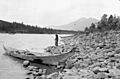
Indigenous girl fishing, Kitwanga, 1915.
-
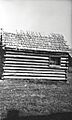
Jail, Kitwanga, 1925.
_(41994622490).jpg)
.jpg)
