Glenmorgan, Queensland facts for kids
Quick facts for kids GlenmorganQueensland |
|||||||||||||||
|---|---|---|---|---|---|---|---|---|---|---|---|---|---|---|---|

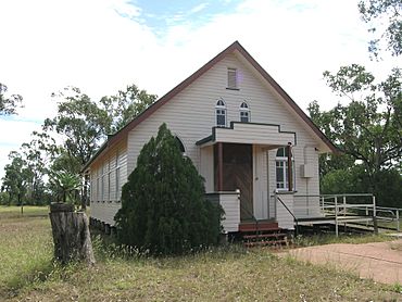
Glenmorgan Community Church
|
|||||||||||||||
| Population | 121 (2021 census) | ||||||||||||||
| • Density | 0.0879/km2 (0.228/sq mi) | ||||||||||||||
| Postcode(s) | 4423 | ||||||||||||||
| Elevation | 288 m (945 ft) | ||||||||||||||
| Area | 1,376.5 km2 (531.5 sq mi) | ||||||||||||||
| Time zone | AEST (UTC+10:00) | ||||||||||||||
| Location | |||||||||||||||
| LGA(s) |
|
||||||||||||||
| State electorate(s) | Warrego | ||||||||||||||
| Federal Division(s) | Maranoa | ||||||||||||||
|
|||||||||||||||
Glenmorgan is a small rural town in Queensland, Australia. It is also a wider area, or "locality," that is split between the Western Downs Region and the Maranoa Region. In 2021, about 121 people lived in the Glenmorgan area.
Contents
Where is Glenmorgan?
Glenmorgan is located in Queensland, Australia. It's about 385 kilometers (239 miles) west of Brisbane, which is the state capital. The main road through the town is called Surat Developmental Road. Inside the town, this road is known as Sybil Street.
Nature Around Town
In the eastern part of Glenmorgan, you'll find Erringibba National Park. This protected area covers about 877 hectares (2,167 acres). Most of the land around Glenmorgan is used for grazing animals on natural plants. Some areas are also used for growing crops.
Glenmorgan's Climate
The weather in Glenmorgan is usually hot in the summer. Winters are generally warm.
A Look Back in Time
The town of Glenmorgan got its name from the Glenmorgan railway station. The station was named after Godfrey Morgan. He was a politician who served in the Queensland Parliament from 1909 to 1938. He was also a grazier (someone who raises livestock) and a journalist. From 1929 to 1932, he was the Secretary for Railways. Many of the local street names in Glenmorgan are named after members of Godfrey Morgan's family. Before it was called Glenmorgan, the area was known as either Cobblegum Creek or Cobblegun Creek.
Important Dates
- 1931: The Glenmorgan railway station opened on December 12.
- 1933: Glenmorgan State School welcomed its first students on July 11.
- 1933: The Glenmorgan Post Office opened on November 1. It closed sometime before 1994.
- 1955: St Andrew's Presbyterian Church opened on October 15. Today, it is known as Glenmorgan Community Church. Different church groups use it for their services.
- 2008: The town won the Queensland Bush Spirit Award. This award recognizes communities that show great spirit and resilience.
What's the Population?
The number of people living in Glenmorgan has changed over the years:
- In 2006, about 86 people lived in the Glenmorgan area.
- In 2016, the population of Glenmorgan was 148 people.
- In 2021, the population was 121 people.
Special Places to Visit
One important local attraction is the heritage-listed Myall Park Botanic Garden. This garden has one of Queensland's oldest collections of plants that grow well in dry areas. A famous plant called Grevillea 'Robyn Gordon' was first grown here.
Learning in Glenmorgan
Glenmorgan State School is a primary school for students from Prep (the first year of school) to Year 6. It's located on Clive Street. In 2017, the school had 11 students and 2 teachers.
There are no high schools in Glenmorgan itself. The closest high schools are in Surat (for students up to Year 10) and Tara (for students up to Year 12). However, these towns are quite far away. Because of the distance, students often use distance education (learning from home with online or mailed materials) or go to a boarding school.
Town Services
Glenmorgan has a Post Office located at 16 Clive Street. There is also a health center called Glenmorgan Outpatients Clinic on Godfrey Street. You can also find a general store in the town.
Community Spots
- The Glenmorgan branch of the Queensland Country Women's Association has rest rooms in town.
- Glenmorgan Community Church is on the corner of Clive Street and Sybil Street. It has a beautiful stained glass window that remembers Mabel Killen. She was the first president of the Glenmorgan Presbyterian Women's Guild.
- The Glenmorgan Returned Soldiers Memorial Hall is on Godfrey Street. The Glenmorgan War Memorial is also located in its grounds.
Fun Things to Do
Glenmorgan hosts an annual rodeo, which is a competition with horses and cattle. They also have a fun and sports day.
Local Attractions
- Monty's Garage and Vintage Car Museum: This museum on Sybil Street looks like a garage from the 1940s. It has a large collection of old cars and trucks that have been restored.
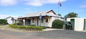
- The "End of The Line" Museum: This museum is located in the old Glenmorgan railway station on Sybil Street. It has many items related to railways. There's also a memorial to Colin and Joyce McKillop, who helped start the museum. You can even camp for free behind the museum!
- Glenmorgan Showground: Located on Methuen Street, this is where events like campdrafts (a sport where riders separate cattle from a herd) and other sports events take place.
See also
 In Spanish: Glenmorgan para niños
 | Claudette Colvin |
 | Myrlie Evers-Williams |
 | Alberta Odell Jones |


