
Granby (CDP), Massachusetts facts for kids
Quick facts for kids
Granby, Massachusetts
|
|
|---|---|

The Church of Christ Congregational
|
|
_highlighted.svg)
Location in Hampshire County in Massachusetts
|
|
| Country | United States |
| State | Massachusetts |
| County | Hampshire |
| Town | Granby |
| Area | |
| • Total | 3.48 sq mi (9.01 km2) |
| • Land | 3.48 sq mi (9.00 km2) |
| • Water | 0.00 sq mi (0.01 km2) |
| Elevation | 312 ft (95 m) |
| Population
(2020)
|
|
| • Total | 1,306 |
| • Density | 375.83/sq mi (145.10/km2) |
| Time zone | UTC-5 (Eastern (EST)) |
| • Summer (DST) | UTC-4 (EDT) |
| ZIP code |
01033
|
| Area code(s) | 413 |
| FIPS code | 25-26500 |
| GNIS feature ID | 0609013 |
Granby is a small community in Hampshire County, Massachusetts, United States. It is known as a census-designated place (CDP). This means it's a specific area that the government counts for population statistics.
In 2010, about 1,368 people lived in the Granby CDP. The larger town of Granby had a total population of 6,240 people. Granby is also part of the Springfield area, which is a larger group of towns and cities.
Contents
Exploring Granby's Location
Granby is located in the west-central part of the town of Granby. Its exact coordinates are 42°15′29″N 72°31′18″W / 42.25806°N 72.52167°W. The CDP includes the main village and some countryside around it.
Granby's Borders and Roads
U.S. Route 202, also called State Street, forms most of Granby's southern edge. However, near the village center, the border goes south along Center Street and Taylor Street. Other borders extend to Greenmeadow Lane and Ingraham Brook in the east. To the north, it reaches Batchelor Brook, Batchelor Street, and Easton Street. On the west side, it goes to Amherst Street and Cold Hill Road.
Nearby Towns and Cities
US Route 202 can take you to other towns. It goes about 6 miles (10 km) east to Belchertown. If you go southwest, it's about 7 miles (11 km) to Holyoke. South Hadley is about 3 miles (5 km) to the west. Downtown Springfield is about 13 miles (21 km) to the south.
Granby's Waterways
The Granby CDP covers about 3.48 square miles (9.0 square kilometers) of land. Only a tiny part, about 0.01 square miles (0.03 square kilometers), is water. Water flows from Granby in two main directions. Batchelor Brook flows north and then west into the Connecticut River. To the south, smaller streams flow into Stony Brook, which also heads west to the Connecticut River.
People Living in Granby
| Historical population | |||
|---|---|---|---|
| Census | Pop. | %± | |
| 2020 | 1,306 | — | |
| U.S. Decennial Census | |||
In 2000, there were 1,344 people living in the Granby CDP. These people lived in 530 households, and 357 of these were families. The population density was about 387 people per square mile (149.5 people per square kilometer). There were 541 homes in the area.
Diversity in Granby
Most people in Granby in 2000 were White (96.43%). A smaller number of people were African American (0.67%), Native American (0.15%), or Asian (0.45%). Some people were from other backgrounds (1.04%) or had mixed backgrounds (1.19%). About 2.31% of the population identified as Hispanic or Latino.
Households and Families
Out of 530 households, about 27.7% had children under 18 living there. More than half (56.8%) were married couples. About 7.7% had a female head of household without a husband present. About 32.6% were not families. Also, 27.9% of all households were single people, and 15.7% had someone living alone who was 65 or older. The average household had 2.54 people, and the average family had 3.12 people.
Age Groups in Granby
The population in Granby was spread across different age groups. About 21.7% were under 18 years old. About 7.7% were between 18 and 24. The largest group, 27.8%, was between 25 and 44. People aged 45 to 64 made up 26.3%, and 16.5% were 65 years or older. The average age in Granby was 41 years. For every 100 females, there were about 89.8 males.
Income Levels
In 2000, the average income for a household in Granby was $51,250. For families, the average income was $59,960. Males earned about $40,611 on average, while females earned about $31,964. The income per person in Granby was $21,631. Very few families (none) and only 1.5% of the total population lived below the poverty line. This included no one under 18 and 3.0% of those over 64.
Images for kids
-
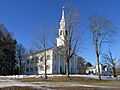
The Church of Christ Congregational
-
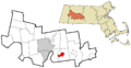
Location in Hampshire County in Massachusetts
See also
 In Spanish: Granby (condado de Hampshire) para niños
